Property Record
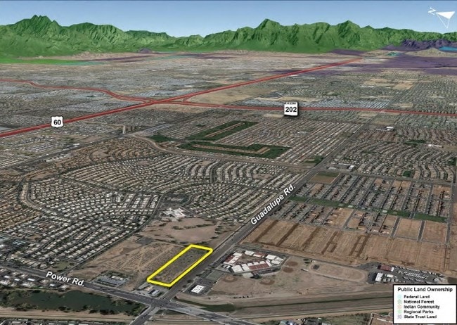
6912 E Guadalupe Rd, Mesa, AZ 85209


Property Detail
6912 E Guadalupe Rd
Phoenix-Mesa-Chandler, AZ
PT OF S 10 AC OF LOT 7 AKA SW4 SW4 SEC 6 DAF COM SE COR LOT 7 WH BEARS 1216.50F E FROM SW COR SEC 6 TH N 1D 36M W 110.04F TO TPOB TH CONT N 1D 36M W 248.34 TH W 885.19F S 01D 24M E 248.32F THE 886.04F TO TPOB
304-05-982A
MARICOPA
Commercialacreage
Arizona
C-G
7
C and X Area of minimal flood hazard, usually depicted on FIRMs as above the 500-year flood level.
5.05 AC
2025
Gateway Airport/Loop 202
2025
Phoenix
422640
NEARBY LISTINGS FOR SALE OR LEASE
-
-
-
-
-
-
No Photo
-
-
-
-
-
-
View all Mesa listings for sale on LoopNet.com
DEMOGRAPHICS near 6912 E Guadalupe Rd
1 mile
3 mile
5 mile
2025 Total Population
15,063
94,993
290,838
2030 Population
15,405
98,801
303,966
Pop Growth 2025-2030
+ 2.27%
+ 4.01%
+ 4.51%
Average Age
36
40
41
2025 Total Households
4,761
34,693
110,048
HH Growth 2025-2030
+ 2.23%
+ 4.08%
+ 4.70%
Median Household Inc
$121,165
$95,353
$88,357
Avg Household Size
3.00
2.70
2.60
2025 Avg HH Vehicles
2.00
2.00
2.00
Median Home Value
$495,525
$453,423
$434,920
Median Year Built
1997
1997
1996
Nearby Places
Map Layers
Map Styles
 Street
 Aerial
Transit
 Traffic
 Biking
Places
Listings with unknown addresses are not visible on the map
- Restaurants
- Banks
- Shops
- Fitness
- Groceries
PUBLIC TRANSPORTATION
AIRPORT
Phoenix-Mesa Gateway
Drive
Walk
Distance
Phoenix-Mesa Gateway
9 min
5.1 mi
Phoenix Sky Harbor International
Drive
Walk
Distance
Phoenix Sky Harbor International
33 min
23.9 mi
Freight Ports
Port of San Diego
Drive
Walk
Distance
Port of San Diego
415 min
377.6 mi
SALE & LEASE HISTORY
LISTING DATE
SALE/LEASE

Jun 01, 2017
For Sale
Nearby Properties
Address
Land Use
TOTAL SIZE
Lot Size
Zoning
Address
Land Use
TOTAL SIZE
Lot Size
Zoning
184.86 AC
Address
Land Use
TOTAL SIZE
Lot Size
Zoning
981,158 SF
43.42 AC
C-G
Address
Land Use
TOTAL SIZE
Lot Size
Zoning
93.03 AC
Address
Land Use
TOTAL SIZE
Lot Size
Zoning
1,195,173 SF
71.41 AC
Address
Land Use
TOTAL SIZE
Lot Size
Zoning
12.66 AC
Address
Land Use
TOTAL SIZE
Lot Size
Zoning
403,171 SF
34.53 AC
PF
Address
Land Use
TOTAL SIZE
Lot Size
Zoning
580,492 SF
41.81 AC
R3
Address
Land Use
TOTAL SIZE
Lot Size
Zoning
4.60 AC
C-C
Address
Land Use
TOTAL SIZE
Lot Size
Zoning
414,288 SF
28.67 AC
LI
Address
Land Use
TOTAL SIZE
Lot Size
Zoning
390,917 SF
15.82 AC
RM4
Address
Land Use
TOTAL SIZE
Lot Size
Zoning
461,845 SF
21.62 AC
LI
Address
Land Use
TOTAL SIZE
Lot Size
Zoning
94,701 SF
7.89 AC
LC
Address
Land Use
TOTAL SIZE
Lot Size
Zoning
274,993 SF
16.44 AC
Address
Land Use
TOTAL SIZE
Lot Size
Zoning
18.75 AC
PF
Address
Land Use
TOTAL SIZE
Lot Size
Zoning
711,933 SF
45.84 AC
Address
Land Use
TOTAL SIZE
Lot Size
Zoning
3.03 AC
C-C
Address
Land Use
TOTAL SIZE
Lot Size
Zoning
330,496 SF
18.63 AC
LI
Address
Land Use
TOTAL SIZE
Lot Size
Zoning
142,871 SF
40.83 AC
PF
Address
Land Use
TOTAL SIZE
Lot Size
Zoning
312,726 SF
17.01 AC
MFL
Address
Land Use
TOTAL SIZE
Lot Size
Zoning
10.63 AC
Address
Land Use
TOTAL SIZE
Lot Size
Zoning
129,201 SF
24.65 AC
LI
Address
Land Use
TOTAL SIZE
Lot Size
Zoning
229,934 SF
15.55 AC
I-1
Address
Land Use
TOTAL SIZE
Lot Size
Zoning
160,296 SF
33.63 AC
PF
Address
Land Use
TOTAL SIZE
Lot Size
Zoning
456,889 SF
25.99 AC
Address
Land Use
TOTAL SIZE
Lot Size
Zoning
269,763 SF
17.49 AC
M-H
Address
Land Use
TOTAL SIZE
Lot Size
Zoning
344,619 SF
13.85 AC
M-H
Address
Land Use
TOTAL SIZE
Lot Size
Zoning
425,158 SF
23.71 AC
M-H
Address
Land Use
TOTAL SIZE
Lot Size
Zoning
98,852 SF
1.23 AC
C-G
Address
Land Use
TOTAL SIZE
Lot Size
Zoning
224,633 SF
13.55 AC
M-M
The World's #1 Commercial Real Estate Marketplace
Connect with us
© 2026 CoStar Group
The information above has been obtained from sources believed reliable. While we do not doubt its accuracy we have not verified it and make no guarantee, warranty or representation about it. It is your responsibility to independently confirm its accuracy and completeness. Any projections, opinions, assumptions, or estimates used are for example only and do not represent the current or future performance of the property. The value of this transaction to you depends on tax and other factors which should be evaluated by your tax, financial, and legal advisors. You and your advisors should conduct a careful, independent investigation of the property to determine to your satisfaction the suitability of the property for your needs.