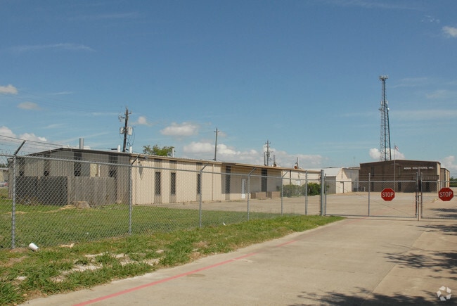
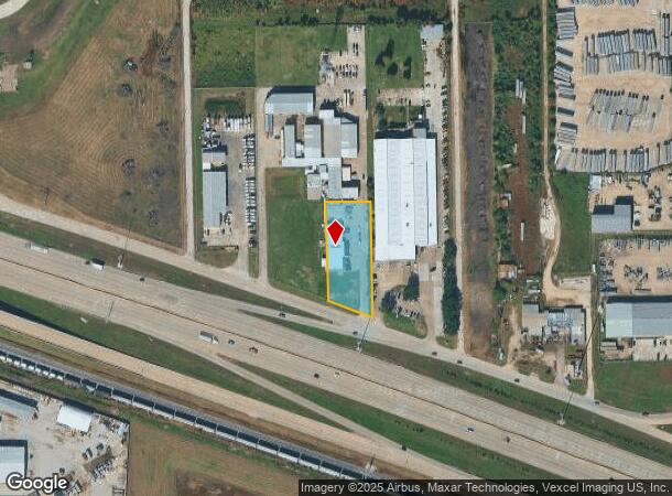
Property Record
6913 Highway 225, Deer Park, TX 77536
NEARBY LISTINGS FOR SALE OR LEASE
Property Detail
6913 Highway 225
0440990000037
Abst 646 G Ross
Officebuilding
TR 10C-2 ABST 646 G ROSS
X
Harris
48201C0930M
Texas
2024
1.07 AC
2025
Channelview
343601
Houston
8,000 SF
Houston-The Woodlands-Sugar Land, TX
DEMOGRAPHICS near 6913 Highway 225
1 Mile
3 Mile
5 Mile
2024 Total Population
1,667
33,301
102,262
2029 Population
1,679
33,702
104,064
Pop Growth 2024-2029
+ 0.72%
+ 1.20%
+ 1.76%
Average Age
39
39
37
2024 Total Households
554
11,700
34,752
HH Growth 2024-2029
+ 0.72%
+ 1.18%
+ 1.75%
Median Household Inc
$95,172
$89,650
$73,640
Avg Household Size
2.90
2.80
2.90
2024 Avg HH Vehicles
3.00
2.00
2.00
Median Home Value
$225,108
$230,792
$189,891
Median Year Built
1985
1980
1980
Nearby Places
Map Layers
Map Styles
 Street
 Aerial
- Restaurants
- Banks
- Shops
- Fitness
- Groceries
PUBLIC TRANSPORTATION
AIRPORT
William P Hobby
DRIVE
WALK
Distance
William P Hobby
29 min
17.6 mi
George Bush Intcntl/Houston
DRIVE
WALK
Distance
George Bush Intcntl/Houston
39 min
30.4 mi
Freight Ports
Port of Houston
DRIVE
WALK
Distance
Port of Houston
21 min
13.4 mi
Nearby Properties
Address
Land Use
TOTAL SIZE
Lot Size
Zoning
Address
Land Use
TOTAL SIZE
Lot Size
Zoning
55.98 AC
Address
Land Use
TOTAL SIZE
Lot Size
Zoning
Address
Land Use
TOTAL SIZE
Lot Size
Zoning
Address
Land Use
TOTAL SIZE
Lot Size
Zoning
12,525,600 SF
260.20 AC
Address
Land Use
TOTAL SIZE
Lot Size
Zoning
263.71 AC
Address
Land Use
TOTAL SIZE
Lot Size
Zoning
4,960,504 SF
141.62 AC
Address
Land Use
TOTAL SIZE
Lot Size
Zoning
8,735,136 SF
185.66 AC
Address
Land Use
TOTAL SIZE
Lot Size
Zoning
36.31 AC
Address
Land Use
TOTAL SIZE
Lot Size
Zoning
167.71 AC
Address
Land Use
TOTAL SIZE
Lot Size
Zoning
67.91 AC
Address
Land Use
TOTAL SIZE
Lot Size
Zoning
64.83 AC
Address
Land Use
TOTAL SIZE
Lot Size
Zoning
19.38 AC
Address
Land Use
TOTAL SIZE
Lot Size
Zoning
13.76 AC
Address
Land Use
TOTAL SIZE
Lot Size
Zoning
102.48 AC
Address
Land Use
TOTAL SIZE
Lot Size
Zoning
Address
Land Use
TOTAL SIZE
Lot Size
Zoning
900,000 SF
42.88 AC
Address
Land Use
TOTAL SIZE
Lot Size
Zoning
120.26 AC
Address
Land Use
TOTAL SIZE
Lot Size
Zoning
Address
Land Use
TOTAL SIZE
Lot Size
Zoning
46.10 AC
Address
Land Use
TOTAL SIZE
Lot Size
Zoning
155.61 AC
Address
Land Use
TOTAL SIZE
Lot Size
Zoning
1,042,908 SF
28.92 AC
Address
Land Use
TOTAL SIZE
Lot Size
Zoning
66.05 AC
Address
Land Use
TOTAL SIZE
Lot Size
Zoning
1,120,800 SF
35.24 AC
Address
Land Use
TOTAL SIZE
Lot Size
Zoning
711,094 SF
35.47 AC
Address
Land Use
TOTAL SIZE
Lot Size
Zoning
22.02 AC
Address
Land Use
TOTAL SIZE
Lot Size
Zoning
197.11 AC
Address
Land Use
TOTAL SIZE
Lot Size
Zoning
66.50 AC
Address
Land Use
TOTAL SIZE
Lot Size
Zoning
371,097 SF
10.32 AC
Address
Land Use
TOTAL SIZE
Lot Size
Zoning
Address
Land Use
TOTAL SIZE
Lot Size
Zoning
The World's #1 Commercial Real Estate Marketplace
Connect with us
© 2025 CoStar Group
The information above has been obtained from sources believed reliable. While we do not doubt its accuracy we have not verified it and make no guarantee, warranty or representation about it. It is your responsibility to independently confirm its accuracy and completeness. Any projections, opinions, assumptions, or estimates used are for example only and do not represent the current or future performance of the property. The value of this transaction to you depends on tax and other factors which should be evaluated by your tax, financial, and legal advisors. You and your advisors should conduct a careful, independent investigation of the property to determine to your satisfaction the suitability of the property for your needs.