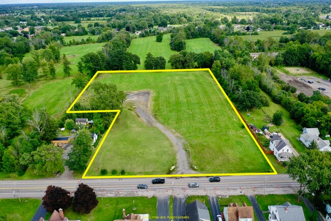
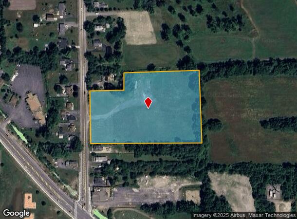
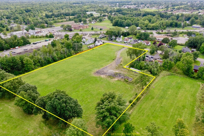
Property Record
6919 Ward Rd, Niagara Falls, NY 14304

NEARBY LISTINGS FOR SALE OR LEASE
-
-
View all Niagara Falls listings for sale on LoopNet.com
Property Detail
6919 Ward Rd
Buffalo-Cheektowaga-Niagara Falls, NY
35-4-2 36 13 8
294000-162-012-0002-054-000
Niagara
Residentialacreage
New York
AE
54.000
36063C0334F
6 AC
2025
Outlying Niagara County
2024
Buffalo/Niagara Falls
022717
DEMOGRAPHICS near 6919 Ward Rd
1 Mile
3 Mile
5 Mile
2024 Total Population
2,945
28,110
80,764
2029 Population
2,885
27,507
79,464
Pop Growth 2024-2029
(2.04%)
(2.15%)
(1.61%)
Average Age
46
45
44
2024 Total Households
1,246
11,921
35,274
HH Growth 2024-2029
(2.33%)
(2.21%)
(1.70%)
Median Household Inc
$95,972
$80,056
$69,582
Avg Household Size
2.30
2.30
2.20
2024 Avg HH Vehicles
2.00
2.00
2.00
Median Home Value
$262,149
$201,882
$181,733
Median Year Built
1982
1970
1960
Nearby Places
- Restaurants
- Banks
- Shops
- Fitness
- Groceries
PUBLIC TRANSPORTATION
COMMUTER RAIL
Niagara Falls Station (Toronto - New York - VIA Rail)
DRIVE
WALK
Distance
Niagara Falls Station (Toronto - New York - VIA Rail)
16 min
9.0 mi
Niagara Falls Amtrak Station (Empire Service - Amtrak, Maple Leaf - Amtrak)
DRIVE
WALK
Distance
Niagara Falls Amtrak Station (Empire Service - Amtrak, Maple Leaf - Amtrak)
16 min
9.3 mi
AIRPORT
Niagara Falls International
DRIVE
WALK
Distance
Niagara Falls International
5 min
3.2 mi
Buffalo Niagara International
DRIVE
WALK
Distance
Buffalo Niagara International
28 min
15.4 mi
Freight Ports
Port of Toledo
DRIVE
WALK
Distance
Port of Toledo
377 min
306.0 mi
SALE & LEASE HISTORY
LISTING DATE
SALE/LEASE

Aug 22, 2024
For Sale
Nearby Properties
Address
Land Use
TOTAL SIZE
Lot Size
Zoning
Address
Land Use
TOTAL SIZE
Lot Size
Zoning
3,600 SF
72.50 AC
Address
Land Use
TOTAL SIZE
Lot Size
Zoning
173,303 SF
24.40 AC
R1-2
Address
Land Use
TOTAL SIZE
Lot Size
Zoning
58,226 SF
16.40 AC
Address
Land Use
TOTAL SIZE
Lot Size
Zoning
137,878 SF
23.60 AC
R1-2
Address
Land Use
TOTAL SIZE
Lot Size
Zoning
325.10 AC
06 - INDUS
Address
Land Use
TOTAL SIZE
Lot Size
Zoning
Address
Land Use
TOTAL SIZE
Lot Size
Zoning
Address
Land Use
TOTAL SIZE
Lot Size
Zoning
34,100 SF
15.75 AC
C-1
Address
Land Use
TOTAL SIZE
Lot Size
Zoning
8.20 AC
R2
Address
Land Use
TOTAL SIZE
Lot Size
Zoning
60,985 SF
4.38 AC
C-1
Address
Land Use
TOTAL SIZE
Lot Size
Zoning
64,815 SF
5.90 AC
Address
Land Use
TOTAL SIZE
Lot Size
Zoning
8.40 AC
Address
Land Use
TOTAL SIZE
Lot Size
Zoning
119,392 SF
6.40 AC
R-2
Address
Land Use
TOTAL SIZE
Lot Size
Zoning
Address
Land Use
TOTAL SIZE
Lot Size
Zoning
62,528 SF
10.30 AC
R1-2
Address
Land Use
TOTAL SIZE
Lot Size
Zoning
30,315 SF
14 AC
Address
Land Use
TOTAL SIZE
Lot Size
Zoning
Address
Land Use
TOTAL SIZE
Lot Size
Zoning
14,409 SF
1.50 AC
C-1
Address
Land Use
TOTAL SIZE
Lot Size
Zoning
41,975 SF
22.40 AC
R1-2
Address
Land Use
TOTAL SIZE
Lot Size
Zoning
Address
Land Use
TOTAL SIZE
Lot Size
Zoning
37,520 SF
8.30 AC
R1-2
Address
Land Use
TOTAL SIZE
Lot Size
Zoning
99,637 SF
5.50 AC
Address
Land Use
TOTAL SIZE
Lot Size
Zoning
47,835 SF
8.30 AC
Address
Land Use
TOTAL SIZE
Lot Size
Zoning
18,170 SF
6.40 AC
Address
Land Use
TOTAL SIZE
Lot Size
Zoning
Address
Land Use
TOTAL SIZE
Lot Size
Zoning
55,268 SF
2.60 AC
C3
Address
Land Use
TOTAL SIZE
Lot Size
Zoning
6,525 SF
2.70 AC
R-C
Address
Land Use
TOTAL SIZE
Lot Size
Zoning
65,000 SF
11 AC
Address
Land Use
TOTAL SIZE
Lot Size
Zoning
98,633 SF
7 AC
M2
Address
Land Use
TOTAL SIZE
Lot Size
Zoning
113,991 SF
10.50 AC
The World's #1 Commercial Real Estate Marketplace
Connect with us
© 2025 CoStar Group
The information above has been obtained from sources believed reliable. While we do not doubt its accuracy we have not verified it and make no guarantee, warranty or representation about it. It is your responsibility to independently confirm its accuracy and completeness. Any projections, opinions, assumptions, or estimates used are for example only and do not represent the current or future performance of the property. The value of this transaction to you depends on tax and other factors which should be evaluated by your tax, financial, and legal advisors. You and your advisors should conduct a careful, independent investigation of the property to determine to your satisfaction the suitability of the property for your needs.