Property Record
692 E 6Th St, Beaumont, CA 92223
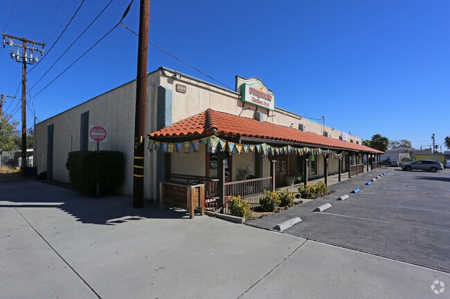

Property Detail
692 E 6Th St
Riverside-San Bernardino-Ontario, CA
Amended Map Of The Town Of Beaumont
418-062-005
LOTS 11, 13 & 15 BLK 87 MB 006/016 SB AMENDED MAP OF THE TOWN OF BEAUMONT
Storebuilding
Riverside
AO
California
06065C0811G
15
2024
0.65 AC
2025
Beaumont/Hemet
043807
Inland Empire (California)
9,292 SF
NEARBY LISTINGS FOR SALE OR LEASE
DEMOGRAPHICS near 692 E 6Th St
1 mile
3 mile
5 mile
2024 Total Population
10,582
57,666
81,037
2029 Population
11,125
60,959
85,917
Pop Growth 2024-2029
+ 5.13%
+ 5.71%
+ 6.02%
Average Age
35
42
41
2024 Total Households
3,209
20,406
28,251
HH Growth 2024-2029
+ 4.71%
+ 5.27%
+ 5.58%
Median Household Inc
$76,095
$79,984
$80,274
Avg Household Size
3.20
2.80
2.80
2024 Avg HH Vehicles
2.00
2.00
2.00
Median Home Value
$341,346
$379,101
$382,660
Median Year Built
1972
2001
2000
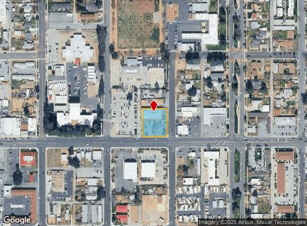
Nearby Places
Map Layers
Map Styles
 Street
 Aerial
Transit
 Traffic
 Biking
Places
Listings with unknown addresses are not visible on the map
- Restaurants
- Banks
- Shops
- Fitness
- Groceries
PUBLIC TRANSPORTATION
AIRPORT
Palm Springs International
Drive
Walk
Distance
Palm Springs International
38 min
31.9 mi
SALE & LEASE HISTORY
LISTING DATE
SALE/LEASE

Nov 04, 2019
For Lease
Mar 06, 2020
For Lease
Mar 06, 2020
For Lease
Jul 21, 2021
For Lease
Jan 10, 2017
For Sale
Aug 22, 2020
For Lease
Nearby Properties
Address
Land Use
TOTAL SIZE
Lot Size
Zoning
Address
Land Use
TOTAL SIZE
Lot Size
Zoning
1,777,707 SF
79.87 AC
SFR
Address
Land Use
TOTAL SIZE
Lot Size
Zoning
2,643,646 SF
59.98 AC
Address
Land Use
TOTAL SIZE
Lot Size
Zoning
600,000 SF
30.81 AC
RA
Address
Land Use
TOTAL SIZE
Lot Size
Zoning
146,056 SF
15.95 AC
Address
Land Use
TOTAL SIZE
Lot Size
Zoning
444,455 SF
19.89 AC
IND
Address
Land Use
TOTAL SIZE
Lot Size
Zoning
95,590 SF
7.48 AC
Address
Land Use
TOTAL SIZE
Lot Size
Zoning
153,303 SF
11.08 AC
Address
Land Use
TOTAL SIZE
Lot Size
Zoning
30.91 AC
Address
Land Use
TOTAL SIZE
Lot Size
Zoning
211,062 SF
11.02 AC
Address
Land Use
TOTAL SIZE
Lot Size
Zoning
216,071 SF
21.90 AC
Address
Land Use
TOTAL SIZE
Lot Size
Zoning
174,418 SF
46.93 AC
Address
Land Use
TOTAL SIZE
Lot Size
Zoning
116,175 SF
4.86 AC
RA
Address
Land Use
TOTAL SIZE
Lot Size
Zoning
44,506 SF
2.35 AC
Address
Land Use
TOTAL SIZE
Lot Size
Zoning
97,103 SF
8 AC
Address
Land Use
TOTAL SIZE
Lot Size
Zoning
39,866 SF
3.55 AC
Address
Land Use
TOTAL SIZE
Lot Size
Zoning
43,105 SF
4.23 AC
Address
Land Use
TOTAL SIZE
Lot Size
Zoning
42,325 SF
2.31 AC
Address
Land Use
TOTAL SIZE
Lot Size
Zoning
44,506 SF
2.84 AC
Address
Land Use
TOTAL SIZE
Lot Size
Zoning
141,286 SF
10.72 AC
Address
Land Use
TOTAL SIZE
Lot Size
Zoning
103,087 SF
8.52 AC
Address
Land Use
TOTAL SIZE
Lot Size
Zoning
200 SF
20.76 AC
C2
Address
Land Use
TOTAL SIZE
Lot Size
Zoning
200 SF
20.76 AC
C2
Address
Land Use
TOTAL SIZE
Lot Size
Zoning
27,359 SF
1.97 AC
C2
Address
Land Use
TOTAL SIZE
Lot Size
Zoning
64,465 SF
3.56 AC
Address
Land Use
TOTAL SIZE
Lot Size
Zoning
127,688 SF
6.75 AC
IND
Address
Land Use
TOTAL SIZE
Lot Size
Zoning
90,184 SF
4.81 AC
C1
Address
Land Use
TOTAL SIZE
Lot Size
Zoning
17.80 AC
W220
The World's #1 Commercial Real Estate Marketplace
Connect with us
© 2026 CoStar Group
The information above has been obtained from sources believed reliable. While we do not doubt its accuracy we have not verified it and make no guarantee, warranty or representation about it. It is your responsibility to independently confirm its accuracy and completeness. Any projections, opinions, assumptions, or estimates used are for example only and do not represent the current or future performance of the property. The value of this transaction to you depends on tax and other factors which should be evaluated by your tax, financial, and legal advisors. You and your advisors should conduct a careful, independent investigation of the property to determine to your satisfaction the suitability of the property for your needs.