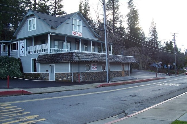
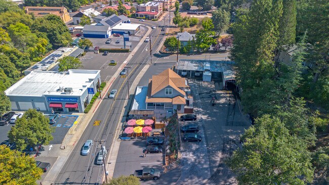
Property Record
692 Main St, Placerville, CA 95667

Property Detail
692 Main St
004-031-020-000
POR BL B PLACERVILLE
Commercialnec
EL DORADO
CG
California
B and X Area of moderate flood hazard, usually the area between the limits of the 100-year and 500-year floods.
1-3
2024
0.30 AC
2025
El Dorado
031200
Sacramento
4,074 SF
Sacramento-Roseville-Folsom, CA
NEARBY LISTINGS FOR SALE OR LEASE
DEMOGRAPHICS near 692 Main St
1 mile
3 mile
5 mile
2024 Total Population
6,936
18,598
31,500
2029 Population
6,942
18,455
31,033
Pop Growth 2024-2029
+ 0.09%
(0.77%)
(1.48%)
Average Age
45
46
46
2024 Total Households
2,964
7,894
13,125
HH Growth 2024-2029
+ 0.10%
(0.77%)
(1.47%)
Median Household Inc
$85,149
$85,208
$88,768
Avg Household Size
2.20
2.30
2.30
2024 Avg HH Vehicles
2.00
2.00
2.00
Median Home Value
$477,456
$522,706
$545,734
Median Year Built
1970
1976
1979
Nearby Places
Map Layers
Map Styles
 Street
 Aerial
Transit
 Traffic
 Biking
Places
Listings with unknown addresses are not visible on the map
- Restaurants
- Banks
- Shops
- Fitness
- Groceries
SALE & LEASE HISTORY
LISTING DATE
SALE/LEASE

Sep 24, 2016
For Sale
Sep 23, 2016
For Sale
Oct 02, 2023
For Sale
Nov 29, 2021
For Lease
Jan 22, 2021
For Sale
Feb 17, 2017
For Sale
Aug 30, 2018
For Lease
Nearby Properties
Address
Land Use
TOTAL SIZE
Lot Size
Zoning
Address
Land Use
TOTAL SIZE
Lot Size
Zoning
201,296 SF
13 AC
Address
Land Use
TOTAL SIZE
Lot Size
Zoning
45,900 SF
6.43 AC
R1A
Address
Land Use
TOTAL SIZE
Lot Size
Zoning
55,043 SF
2.57 AC
RE
Address
Land Use
TOTAL SIZE
Lot Size
Zoning
131,146 SF
18.51 AC
C
Address
Land Use
TOTAL SIZE
Lot Size
Zoning
97,000 SF
17.05 AC
R1A
Address
Land Use
TOTAL SIZE
Lot Size
Zoning
47,760 SF
3.60 AC
R1A
Address
Land Use
TOTAL SIZE
Lot Size
Zoning
55,216 SF
6.60 AC
R106
Address
Land Use
TOTAL SIZE
Lot Size
Zoning
56,609 SF
4.52 AC
CG
Address
Land Use
TOTAL SIZE
Lot Size
Zoning
8,100 SF
10.60 AC
Address
Land Use
TOTAL SIZE
Lot Size
Zoning
4,688 SF
12.28 AC
R106
Address
Land Use
TOTAL SIZE
Lot Size
Zoning
7.13 AC
Address
Land Use
TOTAL SIZE
Lot Size
Zoning
58,175 SF
6.62 AC
C
Address
Land Use
TOTAL SIZE
Lot Size
Zoning
3,072 SF
3.83 AC
Address
Land Use
TOTAL SIZE
Lot Size
Zoning
30,836 SF
2.78 AC
RM
Address
Land Use
TOTAL SIZE
Lot Size
Zoning
88,976 SF
6.34 AC
R2
Address
Land Use
TOTAL SIZE
Lot Size
Zoning
4.81 AC
R1A
Address
Land Use
TOTAL SIZE
Lot Size
Zoning
212,572 SF
4.99 AC
R1A
Address
Land Use
TOTAL SIZE
Lot Size
Zoning
26,903 SF
6.47 AC
Address
Land Use
TOTAL SIZE
Lot Size
Zoning
61,936 SF
8.60 AC
Address
Land Use
TOTAL SIZE
Lot Size
Zoning
68,277 SF
4.65 AC
R2
Address
Land Use
TOTAL SIZE
Lot Size
Zoning
14,820 SF
1.69 AC
CG
Address
Land Use
TOTAL SIZE
Lot Size
Zoning
59,265 SF
7.65 AC
R2
Address
Land Use
TOTAL SIZE
Lot Size
Zoning
32,450 SF
2.71 AC
I
Address
Land Use
TOTAL SIZE
Lot Size
Zoning
2.35 AC
Address
Land Use
TOTAL SIZE
Lot Size
Zoning
64,504 SF
3.67 AC
R1A
Address
Land Use
TOTAL SIZE
Lot Size
Zoning
10,070 SF
1.56 AC
C
Address
Land Use
TOTAL SIZE
Lot Size
Zoning
74,718 SF
2.08 AC
CG
Address
Land Use
TOTAL SIZE
Lot Size
Zoning
28,056 SF
2.21 AC
CG
Address
Land Use
TOTAL SIZE
Lot Size
Zoning
25,050 SF
2.08 AC
RE
Address
Land Use
TOTAL SIZE
Lot Size
Zoning
48,440 SF
5.11 AC
The World's #1 Commercial Real Estate Marketplace
Connect with us
© 2026 CoStar Group
The information above has been obtained from sources believed reliable. While we do not doubt its accuracy we have not verified it and make no guarantee, warranty or representation about it. It is your responsibility to independently confirm its accuracy and completeness. Any projections, opinions, assumptions, or estimates used are for example only and do not represent the current or future performance of the property. The value of this transaction to you depends on tax and other factors which should be evaluated by your tax, financial, and legal advisors. You and your advisors should conduct a careful, independent investigation of the property to determine to your satisfaction the suitability of the property for your needs.