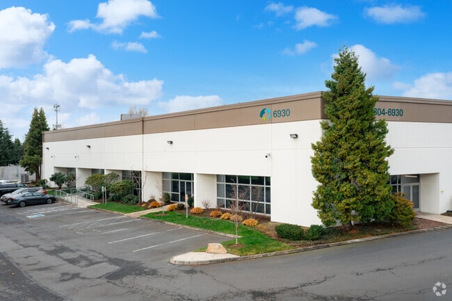
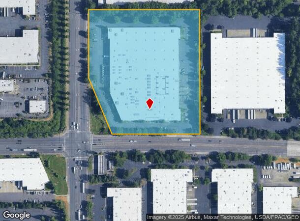
Property Record
6920 S 212Th St, Kent, WA 98032

NEARBY LISTINGS FOR SALE OR LEASE
Property Detail
6920 S 212Th St
122204-9012
S 696.96 FT OF W 625.00 FT OF PORTION NW QTR NW QTR STR 12-22-04 LYING NORTH OF N LINE OF COUNTY ROAD NO 22 (OBRIEN-DES MOINES RD) & EAST OF E LINE SECONDARY ST HWY NO 5-M (W VALLEY HWY) EXC PORTIONS THEREOF CONVEYED TO STATE OF WA FOR HIGHWAY PURPOS
Warehouse
King
AE
Washington
53033C0986G
122204
2025
8.29 AC
2024
Kent Valley N
029206
Seattle/Puget Sound
185,201 SF
Seattle-Tacoma-Bellevue, WA
DEMOGRAPHICS near 6920 S 212Th St
1 Mile
3 Mile
5 Mile
2024 Total Population
212
95,637
271,460
2029 Population
216
96,907
273,427
Pop Growth 2024-2029
+ 1.89%
+ 1.33%
+ 0.72%
Average Age
38
38
39
2024 Total Households
77
34,998
97,491
HH Growth 2024-2029
+ 1.30%
+ 1.25%
+ 0.57%
Median Household Inc
$75,893
$73,002
$81,383
Avg Household Size
2.60
2.60
2.70
2024 Avg HH Vehicles
1.00
2.00
2.00
Median Home Value
$333,333
$458,002
$489,223
Median Year Built
1999
1985
1982
Nearby Places
Map Layers
Map Styles
 Street
 Aerial
- Restaurants
- Banks
- Shops
- Fitness
- Groceries
PUBLIC TRANSPORTATION
COMMUTER RAIL
Kent Station (Sounder South Line - Central Puget Sound Regional Transit Authority Rail (Link Light Rail/Sounder))
DRIVE
WALK
Distance
Kent Station (Sounder South Line - Central Puget Sound Regional Transit Authority Rail (Link Light Rail/Sounder))
5 min
2.8 mi
Kent Station (Seattle - Tacoma/Lakewood - Sound Transit)
DRIVE
WALK
Distance
Kent Station (Seattle - Tacoma/Lakewood - Sound Transit)
5 min
2.8 mi
AIRPORT
Seattle-Tacoma International
DRIVE
WALK
Distance
Seattle-Tacoma International
16 min
6.3 mi
Freight Ports
Port of Seattle
DRIVE
WALK
Distance
Port of Seattle
25 min
15.5 mi
SALE & LEASE HISTORY
LISTING DATE
SALE/LEASE

Sep 25, 2016
For Lease
May 18, 2020
For Lease
Nearby Properties
Address
Land Use
TOTAL SIZE
Lot Size
Zoning
Address
Land Use
TOTAL SIZE
Lot Size
Zoning
410,595 SF
10.64 AC
CO
Address
Land Use
TOTAL SIZE
Lot Size
Zoning
830,533 SF
43.51 AC
I1
Address
Land Use
TOTAL SIZE
Lot Size
Zoning
233,000 SF
9.76 AC
DCE
Address
Land Use
TOTAL SIZE
Lot Size
Zoning
99,000 SF
35.92 AC
I2
Address
Land Use
TOTAL SIZE
Lot Size
Zoning
342,484 SF
58.76 AC
I2
Address
Land Use
TOTAL SIZE
Lot Size
Zoning
586,791 SF
47.46 AC
MR-M
Address
Land Use
TOTAL SIZE
Lot Size
Zoning
441,216 SF
29.58 AC
MR-H
Address
Land Use
TOTAL SIZE
Lot Size
Zoning
246,430 SF
24.65 AC
I1
Address
Land Use
TOTAL SIZE
Lot Size
Zoning
654,530 SF
29.71 AC
I2
Address
Land Use
TOTAL SIZE
Lot Size
Zoning
294,190 SF
10 AC
CC-MU
Address
Land Use
TOTAL SIZE
Lot Size
Zoning
213,468 SF
23.67 AC
CB-C
Address
Land Use
TOTAL SIZE
Lot Size
Zoning
144,600 SF
28.07 AC
I2
Address
Land Use
TOTAL SIZE
Lot Size
Zoning
298,150 SF
9.17 AC
CB-C
Address
Land Use
TOTAL SIZE
Lot Size
Zoning
278,208 SF
24.37 AC
I2
Address
Land Use
TOTAL SIZE
Lot Size
Zoning
99,000 SF
21.59 AC
I2
Address
Land Use
TOTAL SIZE
Lot Size
Zoning
435,187 SF
31.48 AC
I2
Address
Land Use
TOTAL SIZE
Lot Size
Zoning
297,018 SF
11.48 AC
MCR
Address
Land Use
TOTAL SIZE
Lot Size
Zoning
154,400 SF
17.09 AC
GC-MU
Address
Land Use
TOTAL SIZE
Lot Size
Zoning
458,197 SF
23.83 AC
I2
Address
Land Use
TOTAL SIZE
Lot Size
Zoning
156,104 SF
24.63 AC
I3
Address
Land Use
TOTAL SIZE
Lot Size
Zoning
436,880 SF
25.62 AC
AVC
Address
Land Use
TOTAL SIZE
Lot Size
Zoning
313,384 SF
16.85 AC
MR-G
Address
Land Use
TOTAL SIZE
Lot Size
Zoning
324,480 SF
17.24 AC
MR-M
Address
Land Use
TOTAL SIZE
Lot Size
Zoning
245,078 SF
6.32 AC
MCR
Address
Land Use
TOTAL SIZE
Lot Size
Zoning
277,840 SF
24.91 AC
MR-G
Address
Land Use
TOTAL SIZE
Lot Size
Zoning
134,100 SF
21.02 AC
I1
Address
Land Use
TOTAL SIZE
Lot Size
Zoning
434,002 SF
19.74 AC
I2
Address
Land Use
TOTAL SIZE
Lot Size
Zoning
15,856 SF
19.64 AC
I1
Address
Land Use
TOTAL SIZE
Lot Size
Zoning
232,885 SF
9.96 AC
I3
Address
Land Use
TOTAL SIZE
Lot Size
Zoning
226,460 SF
30.69 AC
I2
The World's #1 Commercial Real Estate Marketplace
Connect with us
© 2025 CoStar Group
The information above has been obtained from sources believed reliable. While we do not doubt its accuracy we have not verified it and make no guarantee, warranty or representation about it. It is your responsibility to independently confirm its accuracy and completeness. Any projections, opinions, assumptions, or estimates used are for example only and do not represent the current or future performance of the property. The value of this transaction to you depends on tax and other factors which should be evaluated by your tax, financial, and legal advisors. You and your advisors should conduct a careful, independent investigation of the property to determine to your satisfaction the suitability of the property for your needs.