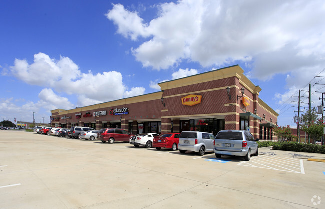
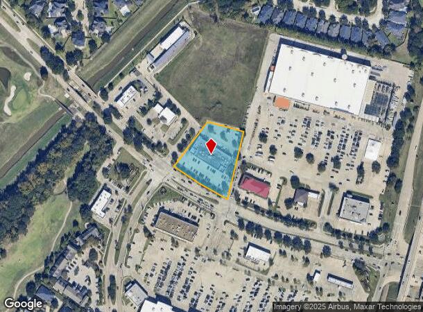
Property Record
6920 S Fry Rd, Katy, TX 77494
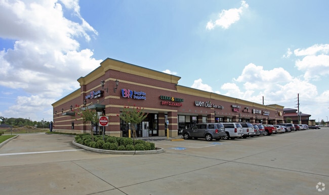
NEARBY LISTINGS FOR SALE OR LEASE
Property Detail
6920 S Fry Rd
Houston
T Hobermaker
Houston-The Woodlands-Sugar Land, TX
0190 T HOBERMAKER, ACRES 1.7196, GRAND PARKWAY PHASE 2 REPLAT NO 1, UNRESTRICTED RESERVE A (COMMERCIAL), (PART)
0190-03-000-1074-914
Fort Bend
Commercialnec
Texas
2024
1.72 AC
2025
Far Katy South
673106
DEMOGRAPHICS near 6920 S Fry Rd
1 Mile
3 Mile
5 Mile
2024 Total Population
11,057
116,660
285,391
2029 Population
13,173
139,223
332,561
Pop Growth 2024-2029
+ 19.14%
+ 19.34%
+ 16.53%
Average Age
39
36
36
2024 Total Households
3,560
36,885
91,226
HH Growth 2024-2029
+ 19.75%
+ 19.85%
+ 16.48%
Median Household Inc
$135,791
$119,767
$112,710
Avg Household Size
3.10
3.10
3.10
2024 Avg HH Vehicles
2.00
2.00
2.00
Median Home Value
$449,270
$362,642
$350,909
Median Year Built
2005
2007
2009
Nearby Places
Map Layers
Map Styles
 Street
 Aerial
- Restaurants
- Banks
- Shops
- Fitness
- Groceries
SALE & LEASE HISTORY
LISTING DATE
SALE/LEASE

Jul 14, 2021
For Lease
Nearby Properties
Address
Land Use
TOTAL SIZE
Lot Size
Zoning
Address
Land Use
TOTAL SIZE
Lot Size
Zoning
786,753 SF
116.13 AC
Address
Land Use
TOTAL SIZE
Lot Size
Zoning
57.20 AC
Address
Land Use
TOTAL SIZE
Lot Size
Zoning
610,000 SF
99.39 AC
Y
Address
Land Use
TOTAL SIZE
Lot Size
Zoning
433,000 SF
59.75 AC
Address
Land Use
TOTAL SIZE
Lot Size
Zoning
350,883 SF
29.41 AC
Address
Land Use
TOTAL SIZE
Lot Size
Zoning
523,641 SF
17.31 AC
X
Address
Land Use
TOTAL SIZE
Lot Size
Zoning
481,055 SF
4.56 AC
Address
Land Use
TOTAL SIZE
Lot Size
Zoning
1,022 SF
21.43 AC
RAD
Address
Land Use
TOTAL SIZE
Lot Size
Zoning
13.15 AC
Address
Land Use
TOTAL SIZE
Lot Size
Zoning
15.88 AC
X
Address
Land Use
TOTAL SIZE
Lot Size
Zoning
168,051 SF
12.68 AC
Address
Land Use
TOTAL SIZE
Lot Size
Zoning
13.36 AC
QY
Address
Land Use
TOTAL SIZE
Lot Size
Zoning
Address
Land Use
TOTAL SIZE
Lot Size
Zoning
95,597 SF
13.46 AC
Address
Land Use
TOTAL SIZE
Lot Size
Zoning
320,427 SF
15.15 AC
Address
Land Use
TOTAL SIZE
Lot Size
Zoning
240,930 SF
15 AC
Address
Land Use
TOTAL SIZE
Lot Size
Zoning
351,505 SF
13.38 AC
Address
Land Use
TOTAL SIZE
Lot Size
Zoning
105,718 SF
14.52 AC
Address
Land Use
TOTAL SIZE
Lot Size
Zoning
26,631 SF
10.61 AC
Address
Land Use
TOTAL SIZE
Lot Size
Zoning
183,216 SF
10.84 AC
Address
Land Use
TOTAL SIZE
Lot Size
Zoning
202,589 SF
9.24 AC
J
Address
Land Use
TOTAL SIZE
Lot Size
Zoning
169,191 SF
14.42 AC
Address
Land Use
TOTAL SIZE
Lot Size
Zoning
101,783 SF
14.43 AC
Address
Land Use
TOTAL SIZE
Lot Size
Zoning
184,398 SF
28.22 AC
I
Address
Land Use
TOTAL SIZE
Lot Size
Zoning
141,552 SF
38.03 AC
TS
Address
Land Use
TOTAL SIZE
Lot Size
Zoning
101,443 SF
11.60 AC
S
Address
Land Use
TOTAL SIZE
Lot Size
Zoning
377,890 SF
12.68 AC
Address
Land Use
TOTAL SIZE
Lot Size
Zoning
390,016 SF
14.44 AC
Address
Land Use
TOTAL SIZE
Lot Size
Zoning
285,735 SF
14.63 AC
Address
Land Use
TOTAL SIZE
Lot Size
Zoning
11.30 AC
The World's #1 Commercial Real Estate Marketplace
Connect with us
© 2025 CoStar Group
The information above has been obtained from sources believed reliable. While we do not doubt its accuracy we have not verified it and make no guarantee, warranty or representation about it. It is your responsibility to independently confirm its accuracy and completeness. Any projections, opinions, assumptions, or estimates used are for example only and do not represent the current or future performance of the property. The value of this transaction to you depends on tax and other factors which should be evaluated by your tax, financial, and legal advisors. You and your advisors should conduct a careful, independent investigation of the property to determine to your satisfaction the suitability of the property for your needs.