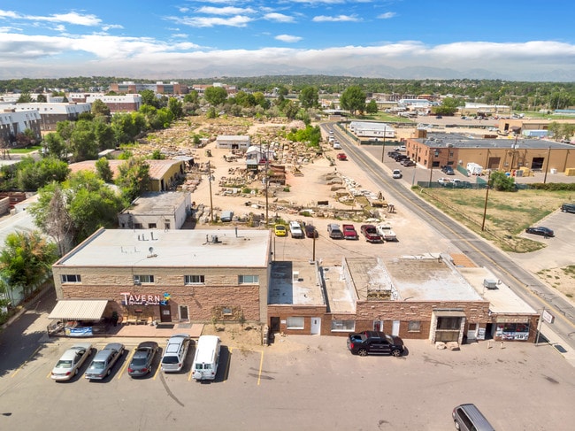
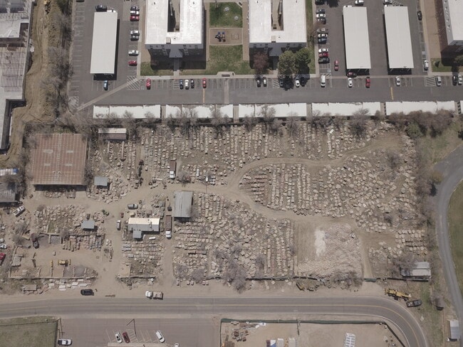
Property Record
6921 Lowell Blvd, Denver, CO 80221


Property Detail
6921 Lowell Blvd
Denver-Aurora-Centennial, CO
SECT,TWN,RNG:6-3-68 DESC: BEG 1660/5 FT S OF NE COR SEC 6 TH W 853/31 FT M/L TH S 270 FT TH E 853/31 FT M/L TH N 270 FT TO POB EXC PARC 90 FT N AND S BY 240 FT E AND W IN SE COR SD TRACT EXC RDS 4/32A
1825-06-1-00-036
Adams
Commercialnec
Colorado
PUD
8
2024
4.32 AC
2025
Northwest Denver
009607
Denver
18,628 SF
NEARBY LISTINGS FOR SALE OR LEASE
DEMOGRAPHICS near 6921 Lowell Blvd
1 mile
3 mile
5 mile
2025 Total Population
18,060
134,873
366,805
2030 Population
18,762
137,926
374,382
Pop Growth 2025-2030
+ 3.89%
+ 2.26%
+ 2.07%
Average Age
38
38
39
2025 Total Households
6,895
50,604
150,476
HH Growth 2025-2030
+ 4.18%
+ 2.31%
+ 2.09%
Median Household Inc
$71,417
$82,924
$94,959
Avg Household Size
2.50
2.60
2.40
2025 Avg HH Vehicles
2.00
2.00
2.00
Median Home Value
$536,371
$487,992
$563,891
Median Year Built
1974
1972
1976
Nearby Places
Map Layers
Map Styles
 Street
 Aerial
Transit
 Traffic
 Biking
Places
Listings with unknown addresses are not visible on the map
- Restaurants
- Banks
- Shops
- Fitness
- Groceries
PUBLIC TRANSPORTATION
COMMUTER RAIL
Drive
Walk
Distance
3 min
8 min
0.4 mi
Drive
Walk
Distance
3 min
8 min
0.4 mi
AIRPORT
Denver International
Drive
Walk
Distance
Denver International
36 min
26.8 mi
SALE & LEASE HISTORY
LISTING DATE
SALE/LEASE

Jul 22, 2024
For Lease
Aug 29, 2018
For Sale
Nearby Properties
Address
Land Use
TOTAL SIZE
Lot Size
Zoning
Address
Land Use
TOTAL SIZE
Lot Size
Zoning
21,306 SF
2.43 AC
Address
Land Use
TOTAL SIZE
Lot Size
Zoning
860,132 SF
68.50 AC
R-5
Address
Land Use
TOTAL SIZE
Lot Size
Zoning
208,500 SF
8.42 AC
Address
Land Use
TOTAL SIZE
Lot Size
Zoning
138,770 SF
4.64 AC
Address
Land Use
TOTAL SIZE
Lot Size
Zoning
138,912 SF
8.71 AC
Address
Land Use
TOTAL SIZE
Lot Size
Zoning
113,385 SF
6.77 AC
Address
Land Use
TOTAL SIZE
Lot Size
Zoning
398,180 SF
33.31 AC
R1C
Address
Land Use
TOTAL SIZE
Lot Size
Zoning
58,750 SF
1.52 AC
Address
Land Use
TOTAL SIZE
Lot Size
Zoning
86,816 SF
4.95 AC
Address
Land Use
TOTAL SIZE
Lot Size
Zoning
79,636 SF
4.91 AC
Address
Land Use
TOTAL SIZE
Lot Size
Zoning
305,110 SF
16.87 AC
Address
Land Use
TOTAL SIZE
Lot Size
Zoning
470,539 SF
23.59 AC
Address
Land Use
TOTAL SIZE
Lot Size
Zoning
110,878 SF
4.65 AC
Address
Land Use
TOTAL SIZE
Lot Size
Zoning
105,600 SF
1.31 AC
Address
Land Use
TOTAL SIZE
Lot Size
Zoning
419,745 SF
24.75 AC
Address
Land Use
TOTAL SIZE
Lot Size
Zoning
390,764 SF
20.19 AC
Address
Land Use
TOTAL SIZE
Lot Size
Zoning
65,336 SF
2.86 AC
Address
Land Use
TOTAL SIZE
Lot Size
Zoning
64,106 SF
4.10 AC
Address
Land Use
TOTAL SIZE
Lot Size
Zoning
74,432 SF
4.47 AC
Address
Land Use
TOTAL SIZE
Lot Size
Zoning
283,572 SF
17.76 AC
Address
Land Use
TOTAL SIZE
Lot Size
Zoning
147,009 SF
36.94 AC
I3
Address
Land Use
TOTAL SIZE
Lot Size
Zoning
69,537 SF
4.49 AC
Address
Land Use
TOTAL SIZE
Lot Size
Zoning
6,731 SF
80.77 AC
Address
Land Use
TOTAL SIZE
Lot Size
Zoning
51,312 SF
2.17 AC
PUD
Address
Land Use
TOTAL SIZE
Lot Size
Zoning
53,602 SF
2.37 AC
Address
Land Use
TOTAL SIZE
Lot Size
Zoning
62,025 SF
2.49 AC
R4
Address
Land Use
TOTAL SIZE
Lot Size
Zoning
157,724 SF
10.07 AC
Address
Land Use
TOTAL SIZE
Lot Size
Zoning
350,400 SF
19.31 AC
Address
Land Use
TOTAL SIZE
Lot Size
Zoning
436,238 SF
13.94 AC
Address
Land Use
TOTAL SIZE
Lot Size
Zoning
281,777 SF
24.89 AC
I2
The World's #1 Commercial Real Estate Marketplace
Connect with us
© 2026 CoStar Group
The information above has been obtained from sources believed reliable. While we do not doubt its accuracy we have not verified it and make no guarantee, warranty or representation about it. It is your responsibility to independently confirm its accuracy and completeness. Any projections, opinions, assumptions, or estimates used are for example only and do not represent the current or future performance of the property. The value of this transaction to you depends on tax and other factors which should be evaluated by your tax, financial, and legal advisors. You and your advisors should conduct a careful, independent investigation of the property to determine to your satisfaction the suitability of the property for your needs.