Property Record
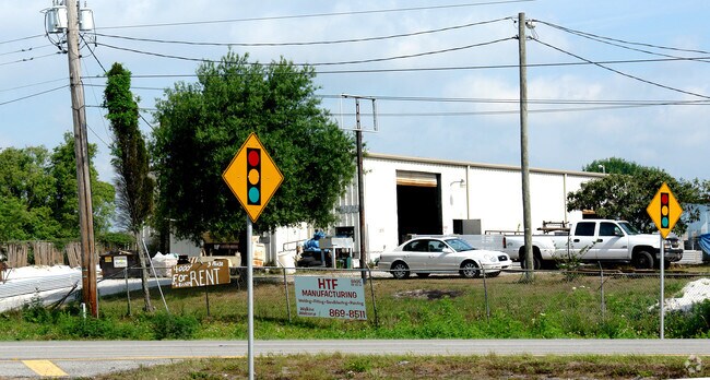
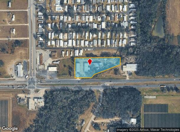
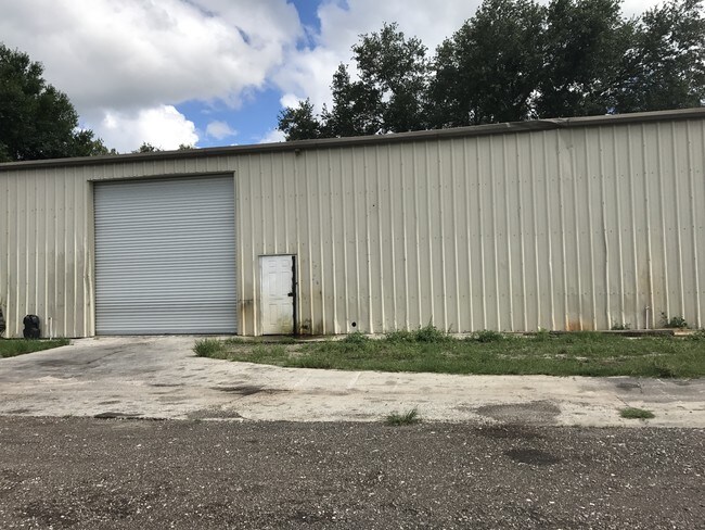
6925 Highway 60 W, Mulberry, FL 33860
NEARBY LISTINGS FOR SALE OR LEASE
-
-
View all Mulberry listings for lease on LoopNet.com
Property Detail
6925 Highway 60 W
23-29-30-000000-043050
Circle X
Warehouse
COMM AT SW COR OF NW1/4 OF SW1/4 N00-00-31E 50 FT N89-34-53E 550 FT TO POB N00-00-31E 234.38 FT N89-37-57E 773.71 FT S00-13-27W 228.14 FT S89-34-53W 772.60 FT TO POB LESS COMM SW COR OF NW1/4 OF SW1/4 N00-00-31E 50 FT N89-23-31E 744.53 FT TO POB CONT
A
Polk
12105C0470G
Florida
2024
2.20 AC
2025
Polk County
014905
Tampa/St Petersburg
12,000 SF
Lakeland-Winter Haven, FL
DEMOGRAPHICS near 6925 Highway 60 W
1 Mile
3 Mile
5 Mile
2024 Total Population
2,222
20,657
48,617
2029 Population
2,620
24,235
56,666
Pop Growth 2024-2029
+ 17.91%
+ 17.32%
+ 16.56%
Average Age
36
37
38
2024 Total Households
698
6,759
16,809
HH Growth 2024-2029
+ 17.77%
+ 17.33%
+ 16.78%
Median Household Inc
$79,327
$66,553
$68,267
Avg Household Size
3.00
2.90
2.80
2024 Avg HH Vehicles
2.00
2.00
2.00
Median Home Value
$288,194
$241,504
$244,068
Median Year Built
1992
1992
1993
Nearby Places
Map Layers
Map Styles
 Street
 Aerial
- Restaurants
- Banks
- Shops
- Fitness
- Groceries
PUBLIC TRANSPORTATION
AIRPORT
Tampa International
DRIVE
WALK
Distance
Tampa International
51 min
34.5 mi
Freight Ports
Port of Tampa Bay
DRIVE
WALK
Distance
Port of Tampa Bay
41 min
26.6 mi
SALE & LEASE HISTORY
LISTING DATE
SALE/LEASE

Sep 25, 2016
For Lease
Sep 24, 2016
For Sale
May 23, 2017
For Lease
Nearby Properties
Address
Land Use
TOTAL SIZE
Lot Size
Zoning
Address
Land Use
TOTAL SIZE
Lot Size
Zoning
882,663 SF
133.57 AC
PUD
Address
Land Use
TOTAL SIZE
Lot Size
Zoning
266,502 SF
51.06 AC
RC
Address
Land Use
TOTAL SIZE
Lot Size
Zoning
20,000 SF
337.40 AC
AM
Address
Land Use
TOTAL SIZE
Lot Size
Zoning
48,882 SF
21.62 AC
Address
Land Use
TOTAL SIZE
Lot Size
Zoning
1,248 SF
229.47 AC
AM
Address
Land Use
TOTAL SIZE
Lot Size
Zoning
516.37 AC
PD
Address
Land Use
TOTAL SIZE
Lot Size
Zoning
1,728 SF
243.05 AC
AS-0.4
Address
Land Use
TOTAL SIZE
Lot Size
Zoning
1,377 SF
554.80 AC
AM
Address
Land Use
TOTAL SIZE
Lot Size
Zoning
24,988 SF
8.28 AC
Address
Land Use
TOTAL SIZE
Lot Size
Zoning
120.27 AC
AM
Address
Land Use
TOTAL SIZE
Lot Size
Zoning
4,778 SF
118.98 AC
AR
Address
Land Use
TOTAL SIZE
Lot Size
Zoning
17,166 SF
2.72 AC
Address
Land Use
TOTAL SIZE
Lot Size
Zoning
86.26 AC
AR
Address
Land Use
TOTAL SIZE
Lot Size
Zoning
8,544 SF
13.90 AC
Address
Land Use
TOTAL SIZE
Lot Size
Zoning
12,472 SF
9.93 AC
ASC-1
Address
Land Use
TOTAL SIZE
Lot Size
Zoning
5,290 SF
3.73 AC
AS-1
Address
Land Use
TOTAL SIZE
Lot Size
Zoning
8,049 SF
20.12 AC
AS-1
Address
Land Use
TOTAL SIZE
Lot Size
Zoning
8,107 SF
7.66 AC
RC
Address
Land Use
TOTAL SIZE
Lot Size
Zoning
9,112 SF
1.17 AC
C3
Address
Land Use
TOTAL SIZE
Lot Size
Zoning
71.21 AC
AR
Address
Land Use
TOTAL SIZE
Lot Size
Zoning
13,732 SF
6.56 AC
AS-1
Address
Land Use
TOTAL SIZE
Lot Size
Zoning
8,800 SF
1.57 AC
Address
Land Use
TOTAL SIZE
Lot Size
Zoning
5,188 SF
41.65 AC
AM
Address
Land Use
TOTAL SIZE
Lot Size
Zoning
12,600 SF
1.99 AC
XX
Address
Land Use
TOTAL SIZE
Lot Size
Zoning
10,625 SF
4.64 AC
Address
Land Use
TOTAL SIZE
Lot Size
Zoning
35.02 AC
AM
Address
Land Use
TOTAL SIZE
Lot Size
Zoning
194.05 AC
Address
Land Use
TOTAL SIZE
Lot Size
Zoning
3,977 SF
7.15 AC
AS-0.4
Address
Land Use
TOTAL SIZE
Lot Size
Zoning
2,496 SF
7.06 AC
CG
The World's #1 Commercial Real Estate Marketplace
Connect with us
© 2025 CoStar Group
The information above has been obtained from sources believed reliable. While we do not doubt its accuracy we have not verified it and make no guarantee, warranty or representation about it. It is your responsibility to independently confirm its accuracy and completeness. Any projections, opinions, assumptions, or estimates used are for example only and do not represent the current or future performance of the property. The value of this transaction to you depends on tax and other factors which should be evaluated by your tax, financial, and legal advisors. You and your advisors should conduct a careful, independent investigation of the property to determine to your satisfaction the suitability of the property for your needs.