Property Record
6927 Madrone Ave, San Diego, CA 92114
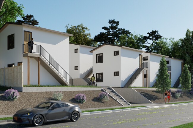


This Property Is For Sale
NEARBY LISTINGS FOR SALE OR LEASE
Property Detail
6927 Madrone Ave
San Diego-Carlsbad, CA
Rancho Mission Of San Diego
581-190-26
San Diego
Sfr
California
X
0.41 AC
06073C1908G
East County
1,395 SF
San Diego
DEMOGRAPHICS near 6927 Madrone Ave
1 Mile
3 Mile
5 Mile
2024 Total Population
22,911
213,248
552,232
2029 Population
22,770
212,843
552,196
Pop Growth 2024-2029
(0.62%)
(0.19%)
(0.01%)
Average Age
39
39
38
2024 Total Households
6,080
62,089
173,840
HH Growth 2024-2029
(0.79%)
(0.36%)
(0.12%)
Median Household Inc
$99,920
$87,483
$84,489
Avg Household Size
3.50
3.30
3.00
2024 Avg HH Vehicles
3.00
2.00
2.00
Median Home Value
$696,037
$694,895
$733,634
Median Year Built
1969
1971
1970
Nearby Places
Map Layers
Map Styles
 Street
 Aerial
- Restaurants
- Banks
- Shops
- Fitness
- Groceries
PUBLIC TRANSPORTATION
TRANSIT/SUBWAY
Encanto/62Nd Street (Orange Line - San Diego Metropolitan Transit System Trolley (San Diego Trolley))
DRIVE
WALK
Distance
Encanto/62Nd Street (Orange Line - San Diego Metropolitan Transit System Trolley (San Diego Trolley))
2 min
19 min
1.0 mi
COMMUTER RAIL
San Diego (Santa Fe Depot) (Coaster - San Diego North County Transit District (Coaster/Sprinter/Breeze))
DRIVE
WALK
Distance
San Diego (Santa Fe Depot) (Coaster - San Diego North County Transit District (Coaster/Sprinter/Breeze))
15 min
8.5 mi
AIRPORT
San Diego International
DRIVE
WALK
Distance
San Diego International
18 min
10.9 mi
Freight Ports
Port of San Diego
DRIVE
WALK
Distance
Port of San Diego
16 min
7.1 mi
Nearby Properties
Address
Land Use
TOTAL SIZE
Lot Size
Zoning
Address
Land Use
TOTAL SIZE
Lot Size
Zoning
15.72 AC
RM-2-5
Address
Land Use
TOTAL SIZE
Lot Size
Zoning
8.99 AC
IL-2-1
Address
Land Use
TOTAL SIZE
Lot Size
Zoning
10.92 AC
RM-2-5
Address
Land Use
TOTAL SIZE
Lot Size
Zoning
9.62 AC
MXD-2
Address
Land Use
TOTAL SIZE
Lot Size
Zoning
10.43 AC
RM-2
Address
Land Use
TOTAL SIZE
Lot Size
Zoning
89,332 SF
1.14 AC
C
Address
Land Use
TOTAL SIZE
Lot Size
Zoning
6.07 AC
MXD-1
Address
Land Use
TOTAL SIZE
Lot Size
Zoning
4.12 AC
RM-2-5
Address
Land Use
TOTAL SIZE
Lot Size
Zoning
Address
Land Use
TOTAL SIZE
Lot Size
Zoning
83,324 SF
5.17 AC
RU
Address
Land Use
TOTAL SIZE
Lot Size
Zoning
11.28 AC
RM-2-5
Address
Land Use
TOTAL SIZE
Lot Size
Zoning
3,274 SF
8.58 AC
RM-2-5
Address
Land Use
TOTAL SIZE
Lot Size
Zoning
7.09 AC
RV
Address
Land Use
TOTAL SIZE
Lot Size
Zoning
10.45 AC
RM-2-5
Address
Land Use
TOTAL SIZE
Lot Size
Zoning
95,506 SF
4.65 AC
RU
Address
Land Use
TOTAL SIZE
Lot Size
Zoning
1.25 AC
C
Address
Land Use
TOTAL SIZE
Lot Size
Zoning
76,798 SF
7.21 AC
I
Address
Land Use
TOTAL SIZE
Lot Size
Zoning
78,723 SF
3.09 AC
R3
Address
Land Use
TOTAL SIZE
Lot Size
Zoning
6.16 AC
CC-2-3
Address
Land Use
TOTAL SIZE
Lot Size
Zoning
10.05 AC
C
Address
Land Use
TOTAL SIZE
Lot Size
Zoning
62,394 SF
2 AC
C36
Address
Land Use
TOTAL SIZE
Lot Size
Zoning
Address
Land Use
TOTAL SIZE
Lot Size
Zoning
13.27 AC
CR-1-1
Address
Land Use
TOTAL SIZE
Lot Size
Zoning
12.33 AC
CR-1-1
Address
Land Use
TOTAL SIZE
Lot Size
Zoning
8.36 AC
CR-1-1
Address
Land Use
TOTAL SIZE
Lot Size
Zoning
58,814 SF
1.61 AC
CC-5-3
Address
Land Use
TOTAL SIZE
Lot Size
Zoning
1.81 AC
R1
Address
Land Use
TOTAL SIZE
Lot Size
Zoning
3,180 SF
10.82 AC
RMH9
Address
Land Use
TOTAL SIZE
Lot Size
Zoning
9.36 AC
RM-2-5
Address
Land Use
TOTAL SIZE
Lot Size
Zoning
6.17 AC
R2
The World's #1 Commercial Real Estate Marketplace
Connect with us
© 2026 CoStar Group
The information above has been obtained from sources believed reliable. While we do not doubt its accuracy we have not verified it and make no guarantee, warranty or representation about it. It is your responsibility to independently confirm its accuracy and completeness. Any projections, opinions, assumptions, or estimates used are for example only and do not represent the current or future performance of the property. The value of this transaction to you depends on tax and other factors which should be evaluated by your tax, financial, and legal advisors. You and your advisors should conduct a careful, independent investigation of the property to determine to your satisfaction the suitability of the property for your needs.