Property Record
6928 E Driscoll St, Long Beach, CA 90815
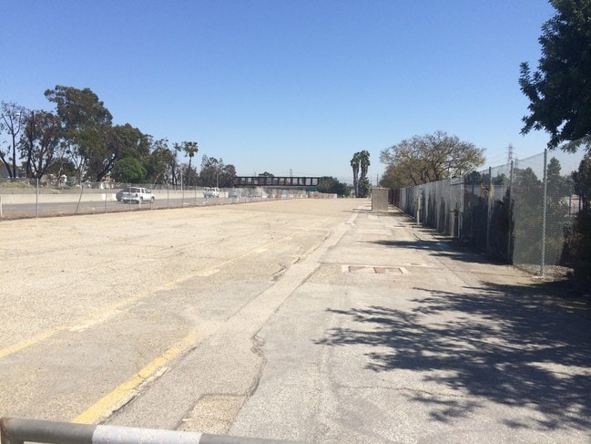
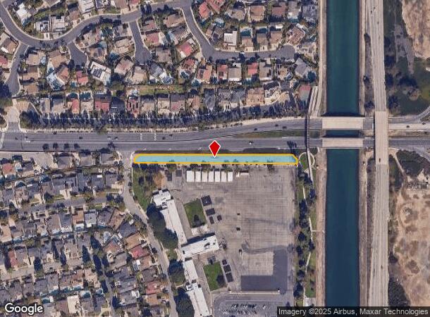
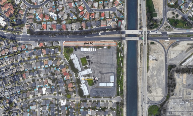
This Property Is For Sale
NEARBY LISTINGS FOR SALE OR LEASE
Property Detail
6928 E Driscoll St
Los Angeles-Long Beach-Glendale, CA
24883
7237-001-001
*TR=24883*LOT COM AT NE COR OF LAND DESC IN FM 20805-3 TO L A CO FLOOD CONTROL DIST TH N ON W LINE OF PALO VERDE AVE AND W ON S LINE OF 7TH ST AND S ON E LINE OF SILVERA AVE TO A PT N 89 5440 TH S 89 5440 E TO BEG POR OF LOT 199
Residentialacreage
Los Angeles
X
California
06037C1988G
199
2024
0.67 AC
2025
Long Beach: Downtown
577602
Los Angeles
DEMOGRAPHICS near 6928 E Driscoll St
1 Mile
3 Mile
5 Mile
2024 Total Population
11,415
144,683
406,728
2029 Population
11,107
140,960
396,201
Pop Growth 2024-2029
(2.70%)
(2.57%)
(2.59%)
Average Age
51
44
41
2024 Total Households
5,427
63,012
158,341
HH Growth 2024-2029
(2.69%)
(2.71%)
(2.69%)
Median Household Inc
$94,054
$95,566
$87,726
Avg Household Size
2.10
2.20
2.50
2024 Avg HH Vehicles
2.00
2.00
2.00
Median Home Value
$773,816
$845,083
$784,160
Median Year Built
1967
1961
1962
Nearby Places
Map Layers
Map Styles
 Street
 Aerial
- Restaurants
- Banks
- Shops
- Fitness
- Groceries
PUBLIC TRANSPORTATION
AIRPORT
Long Beach (Daugherty Field)
DRIVE
WALK
Distance
Long Beach (Daugherty Field)
10 min
7.6 mi
John Wayne/Orange County
DRIVE
WALK
Distance
John Wayne/Orange County
20 min
16.2 mi
Los Angeles International
DRIVE
WALK
Distance
Los Angeles International
34 min
26.5 mi
Freight Ports
Port of Long Beach
DRIVE
WALK
Distance
Port of Long Beach
14 min
6.2 mi
Nearby Properties
Address
Land Use
TOTAL SIZE
Lot Size
Zoning
Address
Land Use
TOTAL SIZE
Lot Size
Zoning
225,557 SF
10.81 AC
LBPD1
Address
Land Use
TOTAL SIZE
Lot Size
Zoning
454,844 SF
11.37 AC
Address
Land Use
TOTAL SIZE
Lot Size
Zoning
927.44 AC
Address
Land Use
TOTAL SIZE
Lot Size
Zoning
1,226.28 AC
Address
Land Use
TOTAL SIZE
Lot Size
Zoning
735.20 AC
Address
Land Use
TOTAL SIZE
Lot Size
Zoning
650.36 AC
Address
Land Use
TOTAL SIZE
Lot Size
Zoning
74,318 SF
NEW SHOP C
Address
Land Use
TOTAL SIZE
Lot Size
Zoning
140,236 SF
9.21 AC
LBR4N
Address
Land Use
TOTAL SIZE
Lot Size
Zoning
199,137 SF
6.39 AC
LBR4R
Address
Land Use
TOTAL SIZE
Lot Size
Zoning
256,538 SF
6.17 AC
NEW SHOPIN
Address
Land Use
TOTAL SIZE
Lot Size
Zoning
11.07 AC
Address
Land Use
TOTAL SIZE
Lot Size
Zoning
120,843 SF
9 AC
LBCCA
Address
Land Use
TOTAL SIZE
Lot Size
Zoning
237,124 SF
5.50 AC
LBCHW
Address
Land Use
TOTAL SIZE
Lot Size
Zoning
89,993 SF
16.81 AC
LBCC
Address
Land Use
TOTAL SIZE
Lot Size
Zoning
414,067 SF
9.31 AC
LBCCA
Address
Land Use
TOTAL SIZE
Lot Size
Zoning
312,469 SF
6.85 AC
LBCCA
Address
Land Use
TOTAL SIZE
Lot Size
Zoning
Address
Land Use
TOTAL SIZE
Lot Size
Zoning
276,622 SF
16.37 AC
LBPD17
Address
Land Use
TOTAL SIZE
Lot Size
Zoning
3.97 AC
Address
Land Use
TOTAL SIZE
Lot Size
Zoning
16.18 AC
Address
Land Use
TOTAL SIZE
Lot Size
Zoning
54,112 SF
15.43 AC
LBPD1
Address
Land Use
TOTAL SIZE
Lot Size
Zoning
73,076 SF
2.53 AC
LBPD1
Address
Land Use
TOTAL SIZE
Lot Size
Zoning
320.34 AC
Address
Land Use
TOTAL SIZE
Lot Size
Zoning
11.97 AC
Address
Land Use
TOTAL SIZE
Lot Size
Zoning
85,992 SF
4.01 AC
LBR4R
Address
Land Use
TOTAL SIZE
Lot Size
Zoning
227,281 SF
2.90 AC
LBR4N
Address
Land Use
TOTAL SIZE
Lot Size
Zoning
3.32 AC
Address
Land Use
TOTAL SIZE
Lot Size
Zoning
200,280 SF
13.17 AC
LBPD1
Address
Land Use
TOTAL SIZE
Lot Size
Zoning
165,343 SF
3.93 AC
Address
Land Use
TOTAL SIZE
Lot Size
Zoning
163,732 SF
3.54 AC
LBR4N
The World's #1 Commercial Real Estate Marketplace
Connect with us
© 2026 CoStar Group
The information above has been obtained from sources believed reliable. While we do not doubt its accuracy we have not verified it and make no guarantee, warranty or representation about it. It is your responsibility to independently confirm its accuracy and completeness. Any projections, opinions, assumptions, or estimates used are for example only and do not represent the current or future performance of the property. The value of this transaction to you depends on tax and other factors which should be evaluated by your tax, financial, and legal advisors. You and your advisors should conduct a careful, independent investigation of the property to determine to your satisfaction the suitability of the property for your needs.