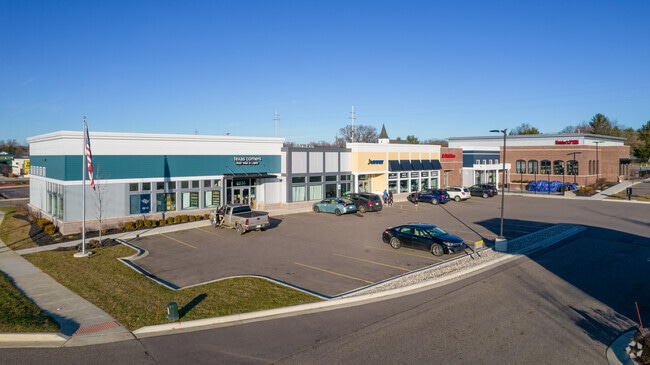
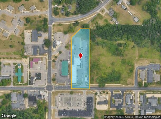
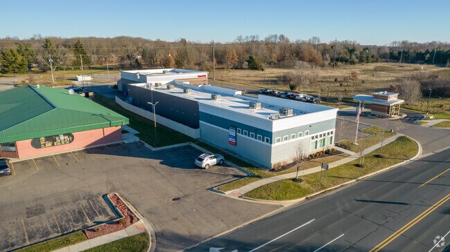
Property Record
6928 W Q Ave, Kalamazoo, MI 49009
NEARBY LISTINGS FOR SALE OR LEASE
Property Detail
6928 W Q Ave
09-14-360-015
SEC 14=3-12 BEG ON S SEC LI 233FT S 89DEG19MIN56SEC E OF SW COR TH N 00DEG16MIN28SEC E PAR WI W SEC LI 564.52FT TO CTR LI
Commercialnec
Kalamazoo
X
Michigan
26077C0285E
2.94 AC
2025
Southern Kalamazoo County
2025
West Michigan
002911
Kalamazoo-Portage, MI
14,518 SF
DEMOGRAPHICS near 6928 W Q Ave
1 Mile
3 Mile
5 Mile
2024 Total Population
3,007
19,124
55,727
2029 Population
3,001
19,030
55,461
Pop Growth 2024-2029
(0.20%)
(0.49%)
(0.48%)
Average Age
38
39
39
2024 Total Households
1,020
7,080
22,171
HH Growth 2024-2029
(0.20%)
(0.55%)
(0.54%)
Median Household Inc
$134,785
$120,286
$86,392
Avg Household Size
3.00
2.70
2.50
2024 Avg HH Vehicles
2.00
2.00
2.00
Median Home Value
$341,201
$333,103
$265,100
Median Year Built
2001
1993
1985
Nearby Places
Map Layers
Map Styles
 Street
 Aerial
- Restaurants
- Banks
- Shops
- Fitness
- Groceries
PUBLIC TRANSPORTATION
AIRPORT
Kalamazoo/Battle Creek International
DRIVE
WALK
Distance
Kalamazoo/Battle Creek International
21 min
10.6 mi
Freight Ports
Port of Toledo
DRIVE
WALK
Distance
Port of Toledo
185 min
152.1 mi
Nearby Properties
Address
Land Use
TOTAL SIZE
Lot Size
Zoning
Address
Land Use
TOTAL SIZE
Lot Size
Zoning
424,967 SF
55.60 AC
I-1
Address
Land Use
TOTAL SIZE
Lot Size
Zoning
140,000 SF
22.69 AC
EBT
Address
Land Use
TOTAL SIZE
Lot Size
Zoning
9.47 AC
Address
Land Use
TOTAL SIZE
Lot Size
Zoning
16.75 AC
CBD
Address
Land Use
TOTAL SIZE
Lot Size
Zoning
5,173 SF
15.81 AC
RM-1
Address
Land Use
TOTAL SIZE
Lot Size
Zoning
4.33 AC
C-1
Address
Land Use
TOTAL SIZE
Lot Size
Zoning
6,874 SF
163.50 AC
PD
Address
Land Use
TOTAL SIZE
Lot Size
Zoning
8.83 AC
I-1
Address
Land Use
TOTAL SIZE
Lot Size
Zoning
92,694 SF
16.10 AC
EBT
Address
Land Use
TOTAL SIZE
Lot Size
Zoning
21,180 SF
13.12 AC
RM-1
Address
Land Use
TOTAL SIZE
Lot Size
Zoning
50.10 AC
C-3
Address
Land Use
TOTAL SIZE
Lot Size
Zoning
7.18 AC
CBD
Address
Land Use
TOTAL SIZE
Lot Size
Zoning
8.92 AC
PD
Address
Land Use
TOTAL SIZE
Lot Size
Zoning
26.89 AC
PD
Address
Land Use
TOTAL SIZE
Lot Size
Zoning
226,877 SF
20.48 AC
I-1
Address
Land Use
TOTAL SIZE
Lot Size
Zoning
7.57 AC
Address
Land Use
TOTAL SIZE
Lot Size
Zoning
44,038 SF
6.50 AC
CBD CORNER
Address
Land Use
TOTAL SIZE
Lot Size
Zoning
1,489 SF
7.79 AC
R-1T
Address
Land Use
TOTAL SIZE
Lot Size
Zoning
14.38 AC
I-1
Address
Land Use
TOTAL SIZE
Lot Size
Zoning
80,550 SF
11.02 AC
R-5
Address
Land Use
TOTAL SIZE
Lot Size
Zoning
192,081 SF
27.50 AC
EBT
Address
Land Use
TOTAL SIZE
Lot Size
Zoning
4.84 AC
OS-1
Address
Land Use
TOTAL SIZE
Lot Size
Zoning
99,400 SF
7.39 AC
I-1
Address
Land Use
TOTAL SIZE
Lot Size
Zoning
38.51 AC
R-6
Address
Land Use
TOTAL SIZE
Lot Size
Zoning
4,424 SF
8.09 AC
RM-1
Address
Land Use
TOTAL SIZE
Lot Size
Zoning
45,322 SF
3.75 AC
C-1
Address
Land Use
TOTAL SIZE
Lot Size
Zoning
47,917 SF
2.13 AC
C-4
Address
Land Use
TOTAL SIZE
Lot Size
Zoning
21,940 SF
8.30 AC
OS-1
Address
Land Use
TOTAL SIZE
Lot Size
Zoning
20,600 SF
3.12 AC
PD
Address
Land Use
TOTAL SIZE
Lot Size
Zoning
76,575 SF
9.28 AC
C-4
The World's #1 Commercial Real Estate Marketplace
Connect with us
© 2026 CoStar Group
The information above has been obtained from sources believed reliable. While we do not doubt its accuracy we have not verified it and make no guarantee, warranty or representation about it. It is your responsibility to independently confirm its accuracy and completeness. Any projections, opinions, assumptions, or estimates used are for example only and do not represent the current or future performance of the property. The value of this transaction to you depends on tax and other factors which should be evaluated by your tax, financial, and legal advisors. You and your advisors should conduct a careful, independent investigation of the property to determine to your satisfaction the suitability of the property for your needs.