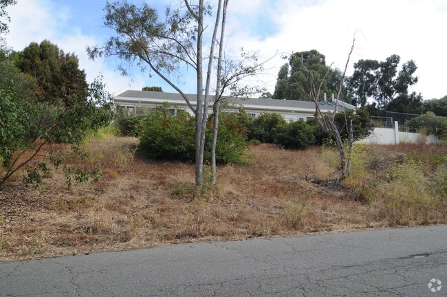
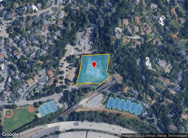
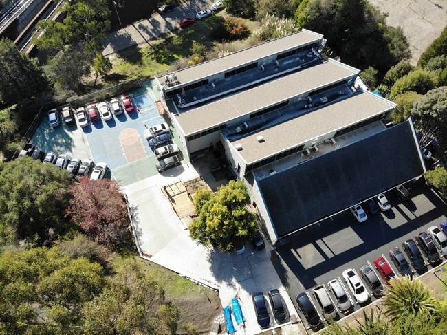
Property Record
6929 Chabot Rd, Oakland, CA 94618

NEARBY LISTINGS FOR SALE OR LEASE
Property Detail
6929 Chabot Rd
Oakland-Hayward-Berkeley, CA
Kellersbergers Plot 72
048A-7084-013-04
LOT: 00004 BLK: 0013 AR: 048A PAGE: 7084
Publicschool
Alameda
X
California
06001C0080G
4
2024
1.87 AC
2025
Oakland-North
404300
East Bay/Oakland
11,829 SF
DEMOGRAPHICS near 6929 Chabot Rd
1 Mile
3 Mile
5 Mile
2024 Total Population
17,437
220,652
464,782
2029 Population
16,876
214,716
452,335
Pop Growth 2024-2029
(3.22%)
(2.69%)
(2.68%)
Average Age
45
40
41
2024 Total Households
7,096
92,444
190,359
HH Growth 2024-2029
(3.42%)
(2.78%)
(2.74%)
Median Household Inc
$192,075
$109,375
$103,990
Avg Household Size
2.30
2.10
2.20
2024 Avg HH Vehicles
2.00
1.00
1.00
Median Home Value
$1,134,147
$1,092,027
$1,065,407
Median Year Built
1948
1952
1953
Nearby Places
Map Layers
Map Styles
 Street
 Aerial
- Restaurants
- Banks
- Shops
- Fitness
- Groceries
PUBLIC TRANSPORTATION
COMMUTER RAIL
DRIVE
WALK
Distance
10 min
3.8 mi
DRIVE
WALK
Distance
9 min
5.6 mi
AIRPORT
Metro Oakland International
DRIVE
WALK
Distance
Metro Oakland International
21 min
13.9 mi
San Francisco International
DRIVE
WALK
Distance
San Francisco International
38 min
24.4 mi
Norman Y Mineta San Jose International
DRIVE
WALK
Distance
Norman Y Mineta San Jose International
56 min
43.8 mi
Freight Ports
Port of Oakland
DRIVE
WALK
Distance
Port of Oakland
10 min
5.3 mi
SALE & LEASE HISTORY
LISTING DATE
SALE/LEASE

Sep 08, 2021
For Sale
May 12, 2020
For Sale
Jan 30, 2020
For Lease
Dec 17, 2018
For Sale
Aug 12, 2022
For Lease
Aug 08, 2019
For Sale
Nearby Properties
Address
Land Use
TOTAL SIZE
Lot Size
Zoning
Address
Land Use
TOTAL SIZE
Lot Size
Zoning
373,594 SF
16.16 AC
Address
Land Use
TOTAL SIZE
Lot Size
Zoning
432,352 SF
Address
Land Use
TOTAL SIZE
Lot Size
Zoning
358,014 SF
5.03 AC
Address
Land Use
TOTAL SIZE
Lot Size
Zoning
423,577 SF
1.04 AC
Address
Land Use
TOTAL SIZE
Lot Size
Zoning
167,071 SF
0.70 AC
Address
Land Use
TOTAL SIZE
Lot Size
Zoning
250,642 SF
17.05 AC
Address
Land Use
TOTAL SIZE
Lot Size
Zoning
703,758 SF
3.44 AC
Address
Land Use
TOTAL SIZE
Lot Size
Zoning
371,322 SF
1.62 AC
Address
Land Use
TOTAL SIZE
Lot Size
Zoning
240,633 SF
1.59 AC
Address
Land Use
TOTAL SIZE
Lot Size
Zoning
261,134 SF
2.23 AC
Address
Land Use
TOTAL SIZE
Lot Size
Zoning
350,741 SF
1.08 AC
Address
Land Use
TOTAL SIZE
Lot Size
Zoning
224,160 SF
5.03 AC
Address
Land Use
TOTAL SIZE
Lot Size
Zoning
292,430 SF
2.09 AC
Address
Land Use
TOTAL SIZE
Lot Size
Zoning
309,451 SF
0.87 AC
Address
Land Use
TOTAL SIZE
Lot Size
Zoning
2.29 AC
Address
Land Use
TOTAL SIZE
Lot Size
Zoning
238,118 SF
2.14 AC
Address
Land Use
TOTAL SIZE
Lot Size
Zoning
60,670 SF
1.57 AC
Address
Land Use
TOTAL SIZE
Lot Size
Zoning
123,750 SF
0.81 AC
Address
Land Use
TOTAL SIZE
Lot Size
Zoning
270,667 SF
2.76 AC
Address
Land Use
TOTAL SIZE
Lot Size
Zoning
203,859 SF
2.35 AC
Address
Land Use
TOTAL SIZE
Lot Size
Zoning
131,862 SF
1.19 AC
Address
Land Use
TOTAL SIZE
Lot Size
Zoning
166,731 SF
0.54 AC
Address
Land Use
TOTAL SIZE
Lot Size
Zoning
111,710 SF
15.47 AC
Address
Land Use
TOTAL SIZE
Lot Size
Zoning
134,608 SF
1.15 AC
Address
Land Use
TOTAL SIZE
Lot Size
Zoning
86,144 SF
0.52 AC
Address
Land Use
TOTAL SIZE
Lot Size
Zoning
137,102 SF
3.63 AC
Address
Land Use
TOTAL SIZE
Lot Size
Zoning
420,858 SF
6.58 AC
Address
Land Use
TOTAL SIZE
Lot Size
Zoning
65,839 SF
0.62 AC
C2
Address
Land Use
TOTAL SIZE
Lot Size
Zoning
143,414 SF
0.63 AC
Address
Land Use
TOTAL SIZE
Lot Size
Zoning
99,124 SF
1.08 AC
The World's #1 Commercial Real Estate Marketplace
Connect with us
© 2025 CoStar Group
The information above has been obtained from sources believed reliable. While we do not doubt its accuracy we have not verified it and make no guarantee, warranty or representation about it. It is your responsibility to independently confirm its accuracy and completeness. Any projections, opinions, assumptions, or estimates used are for example only and do not represent the current or future performance of the property. The value of this transaction to you depends on tax and other factors which should be evaluated by your tax, financial, and legal advisors. You and your advisors should conduct a careful, independent investigation of the property to determine to your satisfaction the suitability of the property for your needs.