Property Record
6929 Wisteria Loop, Land O Lakes, FL 34638
NEARBY LISTINGS FOR SALE OR LEASE
Property Detail
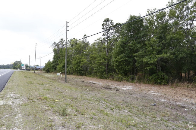
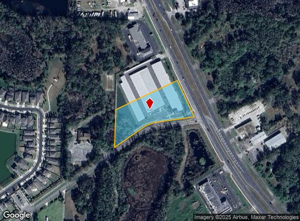
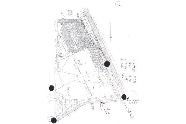
6929 Wisteria Loop
Tampa-St. Petersburg-Clearwater, FL
Ivelmar Estates
02-26-18-0020-01400-0060
IVELMAR ESTATES PB 4 PG 55 A PART OF TRACT 14 DESC AS COM AT NE CORNER TRACT 14 TH S24DG 4845E 471.41 FT FOR POB TH CONT S24DEG 4845E 285.98 FT TH S82DEG 3613W 262.98 FT TH ALG ARC CV LEFT RAD 239.12 FT CHD BRG&DIST S68DEG 5904W 112.62 FT TH S55DEG 3
Warehouse
Pasco
A
Florida
12101C0238F
6
2024
2.58 AC
2025
Pasco County
031903
Tampa/St Petersburg
86,933 SF
DEMOGRAPHICS near 6929 Wisteria Loop
1 Mile
3 Mile
5 Mile
2024 Total Population
2,836
25,674
67,434
2029 Population
3,432
31,107
81,568
Pop Growth 2024-2029
+ 21.02%
+ 21.16%
+ 20.96%
Average Age
47
40
39
2024 Total Households
1,185
8,635
22,974
HH Growth 2024-2029
+ 21.01%
+ 21.17%
+ 20.94%
Median Household Inc
$102,422
$104,105
$104,663
Avg Household Size
2.40
2.80
2.80
2024 Avg HH Vehicles
2.00
2.00
2.00
Median Home Value
$360,738
$343,093
$338,699
Median Year Built
2004
2006
2005
Nearby Places
- Restaurants
- Banks
- Shops
- Fitness
- Groceries
PUBLIC TRANSPORTATION
AIRPORT
Tampa International
DRIVE
WALK
Distance
Tampa International
40 min
27.5 mi
St Pete-Clearwater International
DRIVE
WALK
Distance
St Pete-Clearwater International
60 min
39.1 mi
Freight Ports
Port of Tampa Bay
DRIVE
WALK
Distance
Port of Tampa Bay
41 min
25.2 mi
Nearby Properties
Address
Land Use
TOTAL SIZE
Lot Size
Zoning
Address
Land Use
TOTAL SIZE
Lot Size
Zoning
368,919 SF
21.43 AC
MPUD
Address
Land Use
TOTAL SIZE
Lot Size
Zoning
384,420 SF
116.64 AC
AC
Address
Land Use
TOTAL SIZE
Lot Size
Zoning
102,301 SF
13.97 AC
MPUD
Address
Land Use
TOTAL SIZE
Lot Size
Zoning
97,631 SF
8.47 AC
R2
Address
Land Use
TOTAL SIZE
Lot Size
Zoning
74,685 SF
4.57 AC
MPUD
Address
Land Use
TOTAL SIZE
Lot Size
Zoning
17.27 AC
MPUD
Address
Land Use
TOTAL SIZE
Lot Size
Zoning
55,252 SF
2.83 AC
MPUD
Address
Land Use
TOTAL SIZE
Lot Size
Zoning
76,379 SF
9.46 AC
MPUD
Address
Land Use
TOTAL SIZE
Lot Size
Zoning
29.47 AC
MPUD
Address
Land Use
TOTAL SIZE
Lot Size
Zoning
62,299 SF
4.32 AC
C2
Address
Land Use
TOTAL SIZE
Lot Size
Zoning
72,431 SF
12 AC
PUD
Address
Land Use
TOTAL SIZE
Lot Size
Zoning
52,016 SF
19.06 AC
MPUD
Address
Land Use
TOTAL SIZE
Lot Size
Zoning
64,347 SF
4.08 AC
PO2
Address
Land Use
TOTAL SIZE
Lot Size
Zoning
39,455 SF
3.03 AC
MF2
Address
Land Use
TOTAL SIZE
Lot Size
Zoning
9,314 SF
16.47 AC
R2
Address
Land Use
TOTAL SIZE
Lot Size
Zoning
35,801 SF
6.91 AC
R1
Address
Land Use
TOTAL SIZE
Lot Size
Zoning
62,443 SF
11.12 AC
R1
Address
Land Use
TOTAL SIZE
Lot Size
Zoning
65,374 SF
8.60 AC
C2
Address
Land Use
TOTAL SIZE
Lot Size
Zoning
22,304 SF
3.08 AC
MPUD
Address
Land Use
TOTAL SIZE
Lot Size
Zoning
20,581 SF
0.50 AC
MPUD
Address
Land Use
TOTAL SIZE
Lot Size
Zoning
38,225 SF
3.03 AC
C2
Address
Land Use
TOTAL SIZE
Lot Size
Zoning
21,671 SF
7 AC
AC
Address
Land Use
TOTAL SIZE
Lot Size
Zoning
14,528 SF
2.40 AC
C2
Address
Land Use
TOTAL SIZE
Lot Size
Zoning
4,365 SF
1.92 AC
MPUD
Address
Land Use
TOTAL SIZE
Lot Size
Zoning
12,067 SF
1.77 AC
C2
Address
Land Use
TOTAL SIZE
Lot Size
Zoning
5,424 SF
1.95 AC
MPUD
Address
Land Use
TOTAL SIZE
Lot Size
Zoning
9,600 SF
9.25 AC
C3
Address
Land Use
TOTAL SIZE
Lot Size
Zoning
36,050 SF
3.79 AC
C2
The World's #1 Commercial Real Estate Marketplace
Connect with us
© 2025 CoStar Group
The information above has been obtained from sources believed reliable. While we do not doubt its accuracy we have not verified it and make no guarantee, warranty or representation about it. It is your responsibility to independently confirm its accuracy and completeness. Any projections, opinions, assumptions, or estimates used are for example only and do not represent the current or future performance of the property. The value of this transaction to you depends on tax and other factors which should be evaluated by your tax, financial, and legal advisors. You and your advisors should conduct a careful, independent investigation of the property to determine to your satisfaction the suitability of the property for your needs.