Property Record
6930 Highway 87 N, Orange, TX 77632
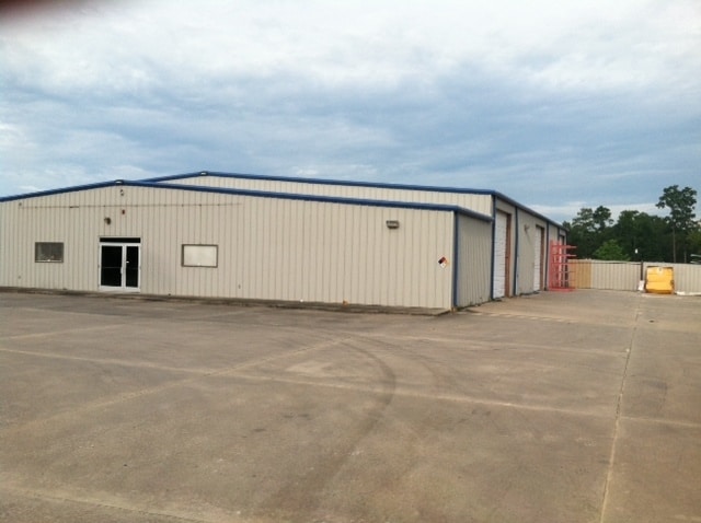

Property Detail
6930 Highway 87 N
000119-072001
119 ABST. 119 BEN JOHNSON, TRACT 153, ACRES 2.95
Commercialnec
ORANGE
AE The base floodplain where base flood elevations are provided. AE Zones are now used on new format FIRMs instead of A1-A30 Zones.
Texas
2025
2.95 AC
2025
Orange County
021000
Beaumont/Port Arthur
12,000 SF
Beaumont-Port Arthur, TX
NEARBY LISTINGS FOR SALE OR LEASE
DEMOGRAPHICS near 6930 Highway 87 N
1 mile
3 mile
5 mile
2025 Total Population
2,244
10,121
26,077
2030 Population
2,235
10,206
26,517
Pop Growth 2025-2030
(0.40%)
+ 0.84%
+ 1.69%
Average Age
42
40
40
2025 Total Households
863
3,943
10,552
HH Growth 2025-2030
(0.23%)
+ 0.89%
+ 1.71%
Median Household Inc
$81,597
$73,100
$57,626
Avg Household Size
2.60
2.60
2.40
2025 Avg HH Vehicles
2.00
2.00
2.00
Median Home Value
$229,139
$195,771
$167,526
Median Year Built
1983
1980
1976
Nearby Places
Map Layers
Map Styles
 Street
 Aerial
Layers
 Traffic
 Biking
Places
Listings with unknown addresses are not visible on the map
- Restaurants
- Banks
- Shops
- Fitness
- Groceries
SALE & LEASE HISTORY
LISTING DATE
SALE/LEASE

Sep 25, 2016
For Lease
Sep 23, 2016
For Sale
Nearby Properties
Address
Land Use
TOTAL SIZE
Lot Size
Zoning
Address
Land Use
TOTAL SIZE
Lot Size
Zoning
153,221 SF
13.82 AC
Address
Land Use
TOTAL SIZE
Lot Size
Zoning
75,598 SF
16.89 AC
Address
Land Use
TOTAL SIZE
Lot Size
Zoning
57,547 SF
6.87 AC
Address
Land Use
TOTAL SIZE
Lot Size
Zoning
28,568 SF
16.36 AC
Address
Land Use
TOTAL SIZE
Lot Size
Zoning
41,148 SF
14.77 AC
Address
Land Use
TOTAL SIZE
Lot Size
Zoning
14,381 SF
3.39 AC
Address
Land Use
TOTAL SIZE
Lot Size
Zoning
170,838 SF
58.01 AC
Address
Land Use
TOTAL SIZE
Lot Size
Zoning
40,986 SF
2.01 AC
Address
Land Use
TOTAL SIZE
Lot Size
Zoning
25,448 SF
12.16 AC
Address
Land Use
TOTAL SIZE
Lot Size
Zoning
100,012 SF
7.78 AC
Address
Land Use
TOTAL SIZE
Lot Size
Zoning
29,314 SF
7 AC
Address
Land Use
TOTAL SIZE
Lot Size
Zoning
37,034 SF
4.04 AC
Address
Land Use
TOTAL SIZE
Lot Size
Zoning
10,000 SF
2.60 AC
Address
Land Use
TOTAL SIZE
Lot Size
Zoning
33,089 SF
1.73 AC
Address
Land Use
TOTAL SIZE
Lot Size
Zoning
26,535 SF
2.39 AC
Address
Land Use
TOTAL SIZE
Lot Size
Zoning
25,010 SF
6.19 AC
Address
Land Use
TOTAL SIZE
Lot Size
Zoning
12,728 SF
21.95 AC
Address
Land Use
TOTAL SIZE
Lot Size
Zoning
22,502 SF
7.37 AC
Address
Land Use
TOTAL SIZE
Lot Size
Zoning
1.72 AC
Address
Land Use
TOTAL SIZE
Lot Size
Zoning
12,442 SF
1.54 AC
Address
Land Use
TOTAL SIZE
Lot Size
Zoning
10,908 SF
5.23 AC
Address
Land Use
TOTAL SIZE
Lot Size
Zoning
1.28 AC
Address
Land Use
TOTAL SIZE
Lot Size
Zoning
28,668 SF
4.45 AC
Address
Land Use
TOTAL SIZE
Lot Size
Zoning
16,742 SF
2.43 AC
Address
Land Use
TOTAL SIZE
Lot Size
Zoning
0.75 AC
Address
Land Use
TOTAL SIZE
Lot Size
Zoning
4,074 SF
0.71 AC
Address
Land Use
TOTAL SIZE
Lot Size
Zoning
10,372 SF
0.63 AC
Address
Land Use
TOTAL SIZE
Lot Size
Zoning
18,750 SF
3.03 AC
Address
Land Use
TOTAL SIZE
Lot Size
Zoning
31,208 SF
2.60 AC
Address
Land Use
TOTAL SIZE
Lot Size
Zoning
33,000 SF
2.89 AC
The World's #1 Commercial Real Estate Marketplace
Connect with us
© 2026 CoStar Group
The information above has been obtained from sources believed reliable. While we do not doubt its accuracy we have not verified it and make no guarantee, warranty or representation about it. It is your responsibility to independently confirm its accuracy and completeness. Any projections, opinions, assumptions, or estimates used are for example only and do not represent the current or future performance of the property. The value of this transaction to you depends on tax and other factors which should be evaluated by your tax, financial, and legal advisors. You and your advisors should conduct a careful, independent investigation of the property to determine to your satisfaction the suitability of the property for your needs.