Property Record
6930 Silverheel St, Shawnee, KS 66226

This Property Is For Sale
Property Detail
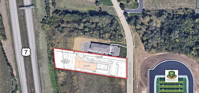
6930 Silverheel St
Kansas City, MO-KS
ZARDA BUSINESS PARK SECOND PLAT, LOT 2
QP92550000-0002
JOHNSON
Farms
Kansas
CH
2
2024
1.24 AC
2025
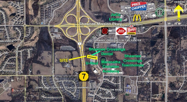
Northwest Johnson County
052611
Kansas City
NEARBY LISTINGS FOR SALE OR LEASE
DEMOGRAPHICS near 6930 Silverheel St
1 mile
3 mile
5 mile
2025 Total Population
5,427
31,783
70,480
2030 Population
5,675
32,939
72,860
Pop Growth 2025-2030
+ 4.57%
+ 3.64%
+ 3.38%
Average Age
40
38
39
2025 Total Households
2,061
10,698
26,194
HH Growth 2025-2030
+ 4.75%
+ 3.84%
+ 3.43%
Median Household Inc
$105,754
$146,838
$122,595
Avg Household Size
2.60
2.90
2.70
2025 Avg HH Vehicles
2.00
2.00
2.00
Median Home Value
$371,403
$421,088
$438,120
Median Year Built
2002
2003
2001
Nearby Places
Map Layers
Map Styles
 Street
 Aerial
Layers
 Traffic
 Biking
Places
Listings with unknown addresses are not visible on the map
- Restaurants
- Banks
- Shops
- Fitness
- Groceries
PUBLIC TRANSPORTATION
AIRPORT
Kansas City International
Drive
Walk
Distance
Kansas City International
43 min
34.5 mi
Nearby Properties
Address
Land Use
TOTAL SIZE
Lot Size
Zoning
Address
Land Use
TOTAL SIZE
Lot Size
Zoning
163,515 SF
70.39 AC
R1
Address
Land Use
TOTAL SIZE
Lot Size
Zoning
202,945 SF
30.29 AC
AG
Address
Land Use
TOTAL SIZE
Lot Size
Zoning
91,639 SF
19.51 AC
R1
Address
Land Use
TOTAL SIZE
Lot Size
Zoning
108,062 SF
14.76 AC
AG
Address
Land Use
TOTAL SIZE
Lot Size
Zoning
32,186 SF
2.80 AC
CH
Address
Land Use
TOTAL SIZE
Lot Size
Zoning
67,008 SF
26.85 AC
AG
Address
Land Use
TOTAL SIZE
Lot Size
Zoning
100,591 SF
33.88 AC
AG
Address
Land Use
TOTAL SIZE
Lot Size
Zoning
99,600 SF
7.77 AC
PI
Address
Land Use
TOTAL SIZE
Lot Size
Zoning
5,940 SF
77.81 AC
PI
Address
Land Use
TOTAL SIZE
Lot Size
Zoning
75,626 SF
17.48 AC
AG
Address
Land Use
TOTAL SIZE
Lot Size
Zoning
79,697 SF
11.36 AC
PSF
Address
Land Use
TOTAL SIZE
Lot Size
Zoning
74,420 SF
20.04 AC
AG
Address
Land Use
TOTAL SIZE
Lot Size
Zoning
80,190 SF
16.86 AC
R-1
Address
Land Use
TOTAL SIZE
Lot Size
Zoning
69,923 SF
11.99 AC
AG
Address
Land Use
TOTAL SIZE
Lot Size
Zoning
52,710 SF
29.55 AC
AG
Address
Land Use
TOTAL SIZE
Lot Size
Zoning
59,640 SF
12.92 AC
PI
Address
Land Use
TOTAL SIZE
Lot Size
Zoning
20,832 SF
19.85 AC
AG
Address
Land Use
TOTAL SIZE
Lot Size
Zoning
40,568 SF
9.85 AC
AG
Address
Land Use
TOTAL SIZE
Lot Size
Zoning
12,746 SF
8.99 AC
AG
Address
Land Use
TOTAL SIZE
Lot Size
Zoning
16,078 SF
19.48 AC
PUDMR
Address
Land Use
TOTAL SIZE
Lot Size
Zoning
19,003 SF
4.47 AC
CH
Address
Land Use
TOTAL SIZE
Lot Size
Zoning
241,418 SF
21.42 AC
PI
Address
Land Use
TOTAL SIZE
Lot Size
Zoning
46,326 SF
4.01 AC
PI
Address
Land Use
TOTAL SIZE
Lot Size
Zoning
83.09 AC
AG
Address
Land Use
TOTAL SIZE
Lot Size
Zoning
161,076 SF
20.27 AC
CH
Address
Land Use
TOTAL SIZE
Lot Size
Zoning
11,519 SF
5.02 AC
PI
Address
Land Use
TOTAL SIZE
Lot Size
Zoning
223,200 SF
14.86 AC
PI
Address
Land Use
TOTAL SIZE
Lot Size
Zoning
9,157 SF
1.46 AC
PUDMR
Address
Land Use
TOTAL SIZE
Lot Size
Zoning
237,397 SF
42.47 AC
PI
Address
Land Use
TOTAL SIZE
Lot Size
Zoning
73,218 SF
4.78 AC
PUDOC
The World's #1 Commercial Real Estate Marketplace
Connect with us
© 2026 CoStar Group
The information above has been obtained from sources believed reliable. While we do not doubt its accuracy we have not verified it and make no guarantee, warranty or representation about it. It is your responsibility to independently confirm its accuracy and completeness. Any projections, opinions, assumptions, or estimates used are for example only and do not represent the current or future performance of the property. The value of this transaction to you depends on tax and other factors which should be evaluated by your tax, financial, and legal advisors. You and your advisors should conduct a careful, independent investigation of the property to determine to your satisfaction the suitability of the property for your needs.