Property Record
69368 Highway 21, Slidell, LA 70458


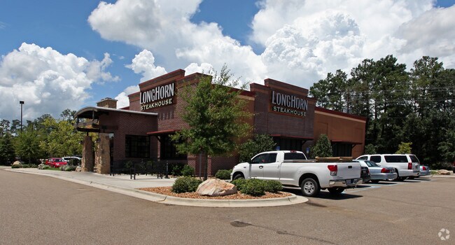
Property Detail
69368 Highway 21
Slidell-Mandeville-Covington, LA
TRACT E-1 CONT 2.141 ACS SEC 47 7 11 INST NO 1351512 INST NO 1416302 INST NO 1599706 INST NO 1682965 INST NO 1764691 (LONGHOR
9596
ST TAMMANY
Commercialnec
Louisiana
2025
2.14 AC
2025
Mandeville/Covington
040900
New Orleans/Metairie/Kenner
5,595 SF
NEARBY LISTINGS FOR SALE OR LEASE
DEMOGRAPHICS near 69368 Highway 21
1 mile
3 mile
5 mile
2024 Total Population
3,980
28,750
74,673
2029 Population
4,155
29,891
77,285
Pop Growth 2024-2029
+ 4.40%
+ 3.97%
+ 3.50%
Average Age
43
42
41
2024 Total Households
1,659
11,313
29,214
HH Growth 2024-2029
+ 4.58%
+ 4.05%
+ 3.54%
Median Household Inc
$66,042
$97,953
$88,815
Avg Household Size
2.30
2.50
2.50
2024 Avg HH Vehicles
2.00
2.00
2.00
Median Home Value
$519,053
$425,399
$370,974
Median Year Built
2010
2003
1999
Nearby Places
Map Layers
Map Styles
 Street
 Aerial
Transit
 Traffic
 Biking
Places
Listings with unknown addresses are not visible on the map
- Restaurants
- Banks
- Shops
- Fitness
- Groceries
PUBLIC TRANSPORTATION
AIRPORT
Louis Armstrong New Orleans International
Drive
Walk
Distance
Louis Armstrong New Orleans International
56 min
41.8 mi
Freight Ports
Port of New Orleans
Drive
Walk
Distance
Port of New Orleans
60 min
42.8 mi
SALE & LEASE HISTORY
LISTING DATE
SALE/LEASE

Jan 26, 2021
For Lease
Nearby Properties
Address
Land Use
TOTAL SIZE
Lot Size
Zoning
Address
Land Use
TOTAL SIZE
Lot Size
Zoning
179,934 SF
20.43 AC
Address
Land Use
TOTAL SIZE
Lot Size
Zoning
200,000 SF
0.28 AC
Address
Land Use
TOTAL SIZE
Lot Size
Zoning
277,159 SF
55.34 AC
Address
Land Use
TOTAL SIZE
Lot Size
Zoning
Address
Land Use
TOTAL SIZE
Lot Size
Zoning
Address
Land Use
TOTAL SIZE
Lot Size
Zoning
0.92 AC
Address
Land Use
TOTAL SIZE
Lot Size
Zoning
11.91 AC
Address
Land Use
TOTAL SIZE
Lot Size
Zoning
Address
Land Use
TOTAL SIZE
Lot Size
Zoning
246,559 SF
42.43 AC
Address
Land Use
TOTAL SIZE
Lot Size
Zoning
105,000 SF
9.37 AC
Address
Land Use
TOTAL SIZE
Lot Size
Zoning
96,067 SF
10.71 AC
Address
Land Use
TOTAL SIZE
Lot Size
Zoning
99,157 SF
12 AC
Address
Land Use
TOTAL SIZE
Lot Size
Zoning
201,095 SF
Address
Land Use
TOTAL SIZE
Lot Size
Zoning
147,767 SF
35.97 AC
Address
Land Use
TOTAL SIZE
Lot Size
Zoning
197,166 SF
14.64 AC
Address
Land Use
TOTAL SIZE
Lot Size
Zoning
77,245 SF
5.58 AC
Address
Land Use
TOTAL SIZE
Lot Size
Zoning
77,994 SF
5.29 AC
Address
Land Use
TOTAL SIZE
Lot Size
Zoning
82,796 SF
19.47 AC
Address
Land Use
TOTAL SIZE
Lot Size
Zoning
Address
Land Use
TOTAL SIZE
Lot Size
Zoning
62,800 SF
15 AC
Address
Land Use
TOTAL SIZE
Lot Size
Zoning
124,002 SF
20.55 AC
Address
Land Use
TOTAL SIZE
Lot Size
Zoning
139,485 SF
16.60 AC
Address
Land Use
TOTAL SIZE
Lot Size
Zoning
130,535 SF
9.63 AC
Address
Land Use
TOTAL SIZE
Lot Size
Zoning
101,742 SF
18.89 AC
Address
Land Use
TOTAL SIZE
Lot Size
Zoning
154,654 SF
15.70 AC
Address
Land Use
TOTAL SIZE
Lot Size
Zoning
97,331 SF
25.37 AC
Address
Land Use
TOTAL SIZE
Lot Size
Zoning
44,371 SF
3.70 AC
Address
Land Use
TOTAL SIZE
Lot Size
Zoning
111,997 SF
8.12 AC
Address
Land Use
TOTAL SIZE
Lot Size
Zoning
2,302 SF
3 AC
Address
Land Use
TOTAL SIZE
Lot Size
Zoning
53,932 SF
5.60 AC
The World's #1 Commercial Real Estate Marketplace
Connect with us
© 2026 CoStar Group
The information above has been obtained from sources believed reliable. While we do not doubt its accuracy we have not verified it and make no guarantee, warranty or representation about it. It is your responsibility to independently confirm its accuracy and completeness. Any projections, opinions, assumptions, or estimates used are for example only and do not represent the current or future performance of the property. The value of this transaction to you depends on tax and other factors which should be evaluated by your tax, financial, and legal advisors. You and your advisors should conduct a careful, independent investigation of the property to determine to your satisfaction the suitability of the property for your needs.