Property Record
6937 Columbia Pike, Annandale, VA 22003
NEARBY LISTINGS FOR SALE OR LEASE
-
-
View all Annandale listings for lease on LoopNet.com
Property Detail
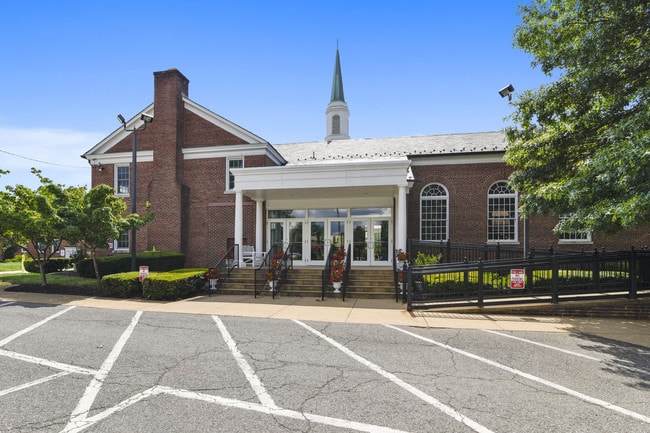
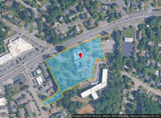
6937 Columbia Pike
Washington-Arlington-Alexandria, DC-VA-MD-WV
Annandale Church
0604-01-0020A
ANNANDALE CHURCH AND LT 25 ALPINE 9197-1523
Religious
Fairfax
X
Virginia
5100540050D
20a
0
6.05 AC
2025
Annandale
452301
Washington, DC
25,224 SF
DEMOGRAPHICS near 6937 Columbia Pike
1 Mile
3 Mile
5 Mile
2024 Total Population
16,615
147,791
469,226
2029 Population
16,428
145,356
461,809
Pop Growth 2024-2029
(1.13%)
(1.65%)
(1.58%)
Average Age
42
39
39
2024 Total Households
5,474
50,286
178,236
HH Growth 2024-2029
(1.32%)
(1.85%)
(1.71%)
Median Household Inc
$118,313
$108,331
$114,554
Avg Household Size
2.90
2.80
2.50
2024 Avg HH Vehicles
2.00
2.00
2.00
Median Home Value
$676,154
$634,186
$658,913
Median Year Built
1966
1966
1971
Nearby Places
Map Layers
Map Styles
 Street
 Aerial
- Restaurants
- Banks
- Shops
- Fitness
- Groceries
PUBLIC TRANSPORTATION
COMMUTER RAIL
Backlick Road (Manassas Line - Virginia Railway Express)
DRIVE
WALK
Distance
Backlick Road (Manassas Line - Virginia Railway Express)
8 min
3.3 mi
Franconia-Springfield (Fredericksburg Line - Virginia Railway Express)
DRIVE
WALK
Distance
Franconia-Springfield (Fredericksburg Line - Virginia Railway Express)
18 min
7.6 mi
AIRPORT
Ronald Reagan Washington Ntl
DRIVE
WALK
Distance
Ronald Reagan Washington Ntl
19 min
10.4 mi
Washington Dulles International
DRIVE
WALK
Distance
Washington Dulles International
38 min
23.5 mi
Freight Ports
Port of Baltimore
DRIVE
WALK
Distance
Port of Baltimore
75 min
55.2 mi
SALE & LEASE HISTORY
LISTING DATE
SALE/LEASE

Jul 26, 2019
For Lease
Nearby Properties
Address
Land Use
TOTAL SIZE
Lot Size
Zoning
Address
Land Use
TOTAL SIZE
Lot Size
Zoning
1,434,346 SF
29.59 AC
430
Address
Land Use
TOTAL SIZE
Lot Size
Zoning
829,629 SF
21.30 AC
430
Address
Land Use
TOTAL SIZE
Lot Size
Zoning
1,464,969 SF
39.52 AC
403
Address
Land Use
TOTAL SIZE
Lot Size
Zoning
613,844 SF
499
Address
Land Use
TOTAL SIZE
Lot Size
Zoning
463,979 SF
19.23 AC
220
Address
Land Use
TOTAL SIZE
Lot Size
Zoning
1,031,040 SF
36.16 AC
220
Address
Land Use
TOTAL SIZE
Lot Size
Zoning
853,724 SF
32.32 AC
220
Address
Land Use
TOTAL SIZE
Lot Size
Zoning
429,735 SF
20 AC
560
Address
Land Use
TOTAL SIZE
Lot Size
Zoning
440,979 SF
20 AC
530
Address
Land Use
TOTAL SIZE
Lot Size
Zoning
3,504 SF
3.37 AC
400
Address
Land Use
TOTAL SIZE
Lot Size
Zoning
431,097 SF
16.45 AC
220
Address
Land Use
TOTAL SIZE
Lot Size
Zoning
452,682 SF
20.74 AC
220
Address
Land Use
TOTAL SIZE
Lot Size
Zoning
415,368 SF
21.06 AC
220
Address
Land Use
TOTAL SIZE
Lot Size
Zoning
401,218 SF
13.78 AC
403
Address
Land Use
TOTAL SIZE
Lot Size
Zoning
485,839 SF
22.59 AC
460
Address
Land Use
TOTAL SIZE
Lot Size
Zoning
358,898 SF
6.44 AC
403
Address
Land Use
TOTAL SIZE
Lot Size
Zoning
485,499 SF
19.11 AC
220
Address
Land Use
TOTAL SIZE
Lot Size
Zoning
8.03 AC
RC
Address
Land Use
TOTAL SIZE
Lot Size
Zoning
12.46 AC
220
Address
Land Use
TOTAL SIZE
Lot Size
Zoning
14.97 AC
220
Address
Land Use
TOTAL SIZE
Lot Size
Zoning
308,693 SF
2.58 AC
400
Address
Land Use
TOTAL SIZE
Lot Size
Zoning
264,495 SF
15.55 AC
403
Address
Land Use
TOTAL SIZE
Lot Size
Zoning
331,010 SF
13.06 AC
220
Address
Land Use
TOTAL SIZE
Lot Size
Zoning
313,817 SF
14.31 AC
220
Address
Land Use
TOTAL SIZE
Lot Size
Zoning
10.39 AC
Address
Land Use
TOTAL SIZE
Lot Size
Zoning
461,369 SF
11.10 AC
403
Address
Land Use
TOTAL SIZE
Lot Size
Zoning
253,647 SF
5.99 AC
220
Address
Land Use
TOTAL SIZE
Lot Size
Zoning
308,062 SF
5.15 AC
403
Address
Land Use
TOTAL SIZE
Lot Size
Zoning
726,520 SF
12.37 AC
220
Address
Land Use
TOTAL SIZE
Lot Size
Zoning
325,576 SF
13.06 AC
RA
The World's #1 Commercial Real Estate Marketplace
Connect with us
© 2025 CoStar Group
The information above has been obtained from sources believed reliable. While we do not doubt its accuracy we have not verified it and make no guarantee, warranty or representation about it. It is your responsibility to independently confirm its accuracy and completeness. Any projections, opinions, assumptions, or estimates used are for example only and do not represent the current or future performance of the property. The value of this transaction to you depends on tax and other factors which should be evaluated by your tax, financial, and legal advisors. You and your advisors should conduct a careful, independent investigation of the property to determine to your satisfaction the suitability of the property for your needs.