Property Record
694 Nutmeg Rd N, South Windsor, CT 06074
NEARBY LISTINGS FOR SALE OR LEASE
Property Detail
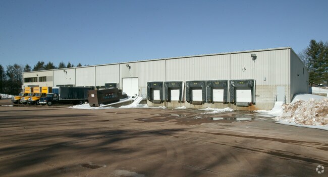
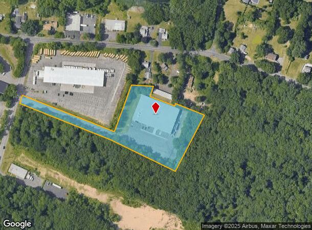
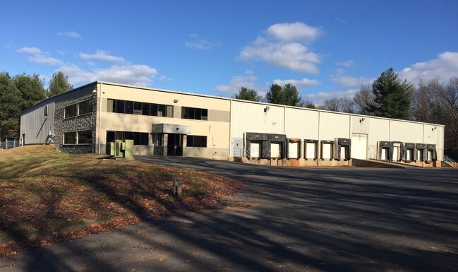
694 Nutmeg Rd N
Industrialgeneral
Hartford
X
Connecticut
09003C0378F
4.06 AC
2024
South Windsor
2025
Hartford
487400
Hartford-West Hartford-East Hartford, CT
35,250 SF
SWIN-000085-000000-000021
DEMOGRAPHICS near 694 Nutmeg Rd N
1 Mile
3 Mile
5 Mile
2024 Total Population
539
21,282
95,913
2029 Population
541
21,121
95,391
Pop Growth 2024-2029
+ 0.37%
(0.76%)
(0.54%)
Average Age
44
42
40
2024 Total Households
216
8,529
38,382
HH Growth 2024-2029
+ 0.46%
(0.84%)
(0.58%)
Median Household Inc
$134,722
$112,703
$86,715
Avg Household Size
2.40
2.40
2.40
2024 Avg HH Vehicles
2.00
2.00
2.00
Median Home Value
$339,814
$282,324
$243,948
Median Year Built
1959
1977
1970
Nearby Places
Map Layers
Map Styles
 Street
 Aerial
- Restaurants
- Banks
- Shops
- Fitness
- Groceries
PUBLIC TRANSPORTATION
COMMUTER RAIL
DRIVE
WALK
Distance
15 min
7.9 mi
Windsor Locks (Hartford Line - CT Rail (CTRail))
DRIVE
WALK
Distance
Windsor Locks (Hartford Line - CT Rail (CTRail))
15 min
8.0 mi
AIRPORT
Bradley International
DRIVE
WALK
Distance
Bradley International
29 min
13.6 mi
Freight Ports
Port of New Haven
DRIVE
WALK
Distance
Port of New Haven
60 min
45.3 mi
Nearby Properties
Address
Land Use
TOTAL SIZE
Lot Size
Zoning
Address
Land Use
TOTAL SIZE
Lot Size
Zoning
13,680 SF
240.83 AC
Address
Land Use
TOTAL SIZE
Lot Size
Zoning
248,364 SF
47.28 AC
A20
Address
Land Use
TOTAL SIZE
Lot Size
Zoning
659,693 SF
102.30 AC
I
Address
Land Use
TOTAL SIZE
Lot Size
Zoning
238.11 AC
GD
Address
Land Use
TOTAL SIZE
Lot Size
Zoning
10.59 AC
GD
Address
Land Use
TOTAL SIZE
Lot Size
Zoning
175,936 SF
18.28 AC
GD
Address
Land Use
TOTAL SIZE
Lot Size
Zoning
301,011 SF
60.83 AC
I
Address
Land Use
TOTAL SIZE
Lot Size
Zoning
6.50 AC
Address
Land Use
TOTAL SIZE
Lot Size
Zoning
421,152 SF
45.95 AC
CD
Address
Land Use
TOTAL SIZE
Lot Size
Zoning
35.05 AC
FP
Address
Land Use
TOTAL SIZE
Lot Size
Zoning
101,317 SF
24.91 AC
RR
Address
Land Use
TOTAL SIZE
Lot Size
Zoning
209,744 SF
25.67 AC
CD
Address
Land Use
TOTAL SIZE
Lot Size
Zoning
259,600 SF
25.58 AC
CD
Address
Land Use
TOTAL SIZE
Lot Size
Zoning
111,800 SF
5.80 AC
GD
Address
Land Use
TOTAL SIZE
Lot Size
Zoning
302,370 SF
16.43 AC
I
Address
Land Use
TOTAL SIZE
Lot Size
Zoning
182,628 SF
15.94 AC
CD
Address
Land Use
TOTAL SIZE
Lot Size
Zoning
156,929 SF
43 AC
GD
Address
Land Use
TOTAL SIZE
Lot Size
Zoning
416,640 SF
30 AC
I
Address
Land Use
TOTAL SIZE
Lot Size
Zoning
62,487 SF
14.35 AC
CD
Address
Land Use
TOTAL SIZE
Lot Size
Zoning
153,247 SF
19.85 AC
I
Address
Land Use
TOTAL SIZE
Lot Size
Zoning
11.14 AC
CD
Address
Land Use
TOTAL SIZE
Lot Size
Zoning
81,412 SF
9.20 AC
GD
Address
Land Use
TOTAL SIZE
Lot Size
Zoning
66,762 SF
17.06 AC
A20
Address
Land Use
TOTAL SIZE
Lot Size
Zoning
69,939 SF
4.62 AC
GD
Address
Land Use
TOTAL SIZE
Lot Size
Zoning
168,000 SF
13.86 AC
I
Address
Land Use
TOTAL SIZE
Lot Size
Zoning
129,695 SF
14.11 AC
GD
Address
Land Use
TOTAL SIZE
Lot Size
Zoning
42,313 SF
5.07 AC
GD
Address
Land Use
TOTAL SIZE
Lot Size
Zoning
59,882 SF
6 AC
RC
Address
Land Use
TOTAL SIZE
Lot Size
Zoning
229,636 SF
15.05 AC
I
Address
Land Use
TOTAL SIZE
Lot Size
Zoning
76,907 SF
6.97 AC
RC
The World's #1 Commercial Real Estate Marketplace
Connect with us
© 2025 CoStar Group
The information above has been obtained from sources believed reliable. While we do not doubt its accuracy we have not verified it and make no guarantee, warranty or representation about it. It is your responsibility to independently confirm its accuracy and completeness. Any projections, opinions, assumptions, or estimates used are for example only and do not represent the current or future performance of the property. The value of this transaction to you depends on tax and other factors which should be evaluated by your tax, financial, and legal advisors. You and your advisors should conduct a careful, independent investigation of the property to determine to your satisfaction the suitability of the property for your needs.