Property Record
69438 Highway 59, Covington, LA 70433
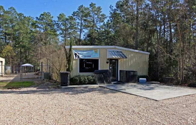

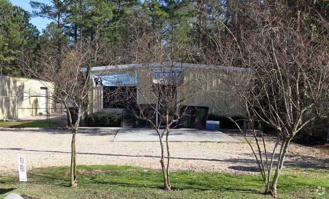
Property Detail
69438 Highway 59
Slidell-Mandeville-Covington, LA
LOTS 1 2 3 4 5 SQ 1 RED GAP ACRES ADD 1 CB 961 570 CB 1183 55 CB 914 75 CB 1054 168 CB 1033 367 INST NO 1948500
23819
ST TAMMANY
Commercialnec
Louisiana
2025
1
2025
5 AC
040602
St Tammany Parish
19,650 SF
New Orleans/Metairie/Kenner
NEARBY LISTINGS FOR SALE OR LEASE
DEMOGRAPHICS near 69438 Highway 59
1 mile
3 mile
5 mile
2025 Total Population
2,026
23,453
64,372
2030 Population
2,100
24,191
66,228
Pop Growth 2025-2030
+ 3.65%
+ 3.15%
+ 2.88%
Average Age
41
41
41
2025 Total Households
770
9,446
25,145
HH Growth 2025-2030
+ 3.77%
+ 3.10%
+ 2.96%
Median Household Inc
$83,176
$74,231
$84,831
Avg Household Size
2.60
2.40
2.50
2025 Avg HH Vehicles
2.00
2.00
2.00
Median Home Value
$254,441
$258,823
$334,055
Median Year Built
1998
1998
1995
Nearby Places
Map Layers
Map Styles
 Street
 Aerial
Layers
 Traffic
 Biking
Places
Listings with unknown addresses are not visible on the map
- Restaurants
- Banks
- Shops
- Fitness
- Groceries
Nearby Properties
Address
Land Use
TOTAL SIZE
Lot Size
Zoning
Address
Land Use
TOTAL SIZE
Lot Size
Zoning
515,547 SF
20.54 AC
Address
Land Use
TOTAL SIZE
Lot Size
Zoning
Address
Land Use
TOTAL SIZE
Lot Size
Zoning
266,213 SF
40 AC
Address
Land Use
TOTAL SIZE
Lot Size
Zoning
68,478 SF
6.64 AC
Address
Land Use
TOTAL SIZE
Lot Size
Zoning
102,470 SF
10.50 AC
Address
Land Use
TOTAL SIZE
Lot Size
Zoning
156,183 SF
20 AC
Address
Land Use
TOTAL SIZE
Lot Size
Zoning
205,612 SF
23.60 AC
Address
Land Use
TOTAL SIZE
Lot Size
Zoning
131,925 SF
2.02 AC
Address
Land Use
TOTAL SIZE
Lot Size
Zoning
92,535 SF
2.80 AC
Address
Land Use
TOTAL SIZE
Lot Size
Zoning
2,053 SF
2 AC
Address
Land Use
TOTAL SIZE
Lot Size
Zoning
114,823 SF
4.57 AC
Address
Land Use
TOTAL SIZE
Lot Size
Zoning
121,705 SF
21.20 AC
Address
Land Use
TOTAL SIZE
Lot Size
Zoning
119,501 SF
20.38 AC
Address
Land Use
TOTAL SIZE
Lot Size
Zoning
86,688 SF
3.75 AC
Address
Land Use
TOTAL SIZE
Lot Size
Zoning
185,093 SF
16.23 AC
Address
Land Use
TOTAL SIZE
Lot Size
Zoning
114,727 SF
4.46 AC
Address
Land Use
TOTAL SIZE
Lot Size
Zoning
Address
Land Use
TOTAL SIZE
Lot Size
Zoning
126 SF
2.55 AC
Address
Land Use
TOTAL SIZE
Lot Size
Zoning
70,689 SF
2.90 AC
Address
Land Use
TOTAL SIZE
Lot Size
Zoning
42,513 SF
7.07 AC
Address
Land Use
TOTAL SIZE
Lot Size
Zoning
94,300 SF
15.21 AC
Address
Land Use
TOTAL SIZE
Lot Size
Zoning
148,494 SF
15.43 AC
Address
Land Use
TOTAL SIZE
Lot Size
Zoning
142 SF
2 AC
Address
Land Use
TOTAL SIZE
Lot Size
Zoning
72,091 SF
3.10 AC
Address
Land Use
TOTAL SIZE
Lot Size
Zoning
46,570 SF
2 AC
Address
Land Use
TOTAL SIZE
Lot Size
Zoning
39,945 SF
4.82 AC
Address
Land Use
TOTAL SIZE
Lot Size
Zoning
107,528 SF
11.24 AC
Address
Land Use
TOTAL SIZE
Lot Size
Zoning
82,035 SF
26.05 AC
Address
Land Use
TOTAL SIZE
Lot Size
Zoning
78,658 SF
12.12 AC
Address
Land Use
TOTAL SIZE
Lot Size
Zoning
38,794 SF
2.79 AC
The World's #1 Commercial Real Estate Marketplace
Connect with us
© 2026 CoStar Group
The information above has been obtained from sources believed reliable. While we do not doubt its accuracy we have not verified it and make no guarantee, warranty or representation about it. It is your responsibility to independently confirm its accuracy and completeness. Any projections, opinions, assumptions, or estimates used are for example only and do not represent the current or future performance of the property. The value of this transaction to you depends on tax and other factors which should be evaluated by your tax, financial, and legal advisors. You and your advisors should conduct a careful, independent investigation of the property to determine to your satisfaction the suitability of the property for your needs.