Property Record
6945 103Rd St, Jacksonville, FL 32210


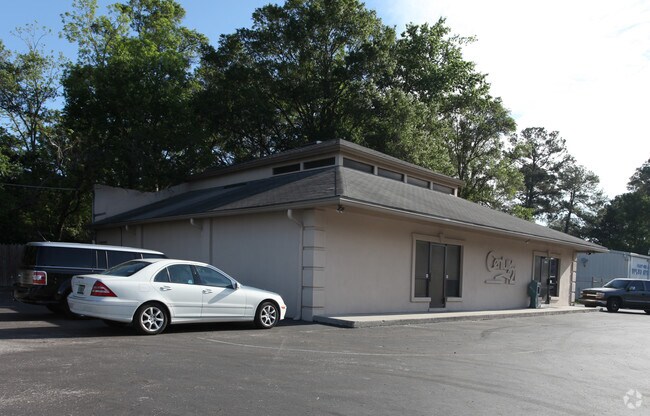
Property Detail
6945 103Rd St
014385-0000
22-93 12-3S-25E .311 R/P OF WESCONNETT ESTATES LOT 27(EX PT IN ST RD)
Officebuilding
Duval
CCG-2
Florida
B and X Area of moderate flood hazard, usually the area between the limits of the 100-year and 500-year floods.
27
2025
0.33 AC
2026
Riverside
012800
Jacksonville (Florida)
4,162 SF
Jacksonville, FL
NEARBY LISTINGS FOR SALE OR LEASE
DEMOGRAPHICS near 6945 103Rd St
1 mile
3 mile
5 mile
2025 Total Population
11,665
89,818
198,951
2030 Population
12,259
95,341
211,122
Pop Growth 2025-2030
+ 5.09%
+ 6.15%
+ 6.12%
Average Age
38
38
38
2025 Total Households
4,346
34,530
77,700
HH Growth 2025-2030
+ 5.41%
+ 6.49%
+ 6.41%
Median Household Inc
$59,833
$57,504
$64,688
Avg Household Size
2.60
2.50
2.50
2025 Avg HH Vehicles
2.00
2.00
2.00
Median Home Value
$178,172
$224,020
$260,491
Median Year Built
1976
1982
1984
Nearby Places
Map Layers
Map Styles
 Street
 Aerial
Layers
 Traffic
 Biking
Places
Listings with unknown addresses are not visible on the map
- Restaurants
- Banks
- Shops
- Fitness
- Groceries
PUBLIC TRANSPORTATION
AIRPORT
Jacksonville International
Drive
Walk
Distance
Jacksonville International
31 min
21.8 mi
Freight Ports
Jacksonville Port
Drive
Walk
Distance
Jacksonville Port
24 min
15.6 mi
Nearby Properties
Address
Land Use
TOTAL SIZE
Lot Size
Zoning
Address
Land Use
TOTAL SIZE
Lot Size
Zoning
402,240 SF
20.66 AC
PUD
Address
Land Use
TOTAL SIZE
Lot Size
Zoning
179,916 SF
12.19 AC
RMD-D
Address
Land Use
TOTAL SIZE
Lot Size
Zoning
188,666 SF
17.76 AC
PUD
Address
Land Use
TOTAL SIZE
Lot Size
Zoning
416,674 SF
18.38 AC
RMD-D
Address
Land Use
TOTAL SIZE
Lot Size
Zoning
203,724 SF
14.71 AC
RMD-D
Address
Land Use
TOTAL SIZE
Lot Size
Zoning
309,137 SF
20.09 AC
RMD-D
Address
Land Use
TOTAL SIZE
Lot Size
Zoning
272,076 SF
54.84 AC
PUD
Address
Land Use
TOTAL SIZE
Lot Size
Zoning
188,578 SF
13.44 AC
RMD-D
Address
Land Use
TOTAL SIZE
Lot Size
Zoning
207,697 SF
16.06 AC
PUD
Address
Land Use
TOTAL SIZE
Lot Size
Zoning
228,290 SF
12.65 AC
RMD-D
Address
Land Use
TOTAL SIZE
Lot Size
Zoning
96,314 SF
21.05 AC
CCG-1
Address
Land Use
TOTAL SIZE
Lot Size
Zoning
276,281 SF
11.72 AC
RMD-D
Address
Land Use
TOTAL SIZE
Lot Size
Zoning
206,513 SF
9.83 AC
RMD-D
Address
Land Use
TOTAL SIZE
Lot Size
Zoning
231,044 SF
10.94 AC
RMD-D
Address
Land Use
TOTAL SIZE
Lot Size
Zoning
137,636 SF
9.73 AC
RMD-D
Address
Land Use
TOTAL SIZE
Lot Size
Zoning
171,412 SF
16.44 AC
RMD-D
Address
Land Use
TOTAL SIZE
Lot Size
Zoning
229,441 SF
17.48 AC
PUD
Address
Land Use
TOTAL SIZE
Lot Size
Zoning
169,084 SF
13 AC
CCG-1
Address
Land Use
TOTAL SIZE
Lot Size
Zoning
152,768 SF
9.66 AC
RMD-D
Address
Land Use
TOTAL SIZE
Lot Size
Zoning
67,581 SF
24.24 AC
PUD
Address
Land Use
TOTAL SIZE
Lot Size
Zoning
159,337 SF
11.09 AC
RMD-D
Address
Land Use
TOTAL SIZE
Lot Size
Zoning
209,238 SF
10.31 AC
RMD-D
Address
Land Use
TOTAL SIZE
Lot Size
Zoning
193,478 SF
10.13 AC
RMD-D
Address
Land Use
TOTAL SIZE
Lot Size
Zoning
160,514 SF
16.36 AC
RMD-D
Address
Land Use
TOTAL SIZE
Lot Size
Zoning
59,810 SF
11.90 AC
CCG-2
Address
Land Use
TOTAL SIZE
Lot Size
Zoning
74,046 SF
7.21 AC
PUD
Address
Land Use
TOTAL SIZE
Lot Size
Zoning
73,769 SF
8.87 AC
CCG-1
Address
Land Use
TOTAL SIZE
Lot Size
Zoning
107,045 SF
9 AC
RMD-D
Address
Land Use
TOTAL SIZE
Lot Size
Zoning
141,403 SF
11.36 AC
PUD
Address
Land Use
TOTAL SIZE
Lot Size
Zoning
52,696 SF
10.11 AC
PUD
The World's #1 Commercial Real Estate Marketplace
Connect with us
© 2026 CoStar Group
The information above has been obtained from sources believed reliable. While we do not doubt its accuracy we have not verified it and make no guarantee, warranty or representation about it. It is your responsibility to independently confirm its accuracy and completeness. Any projections, opinions, assumptions, or estimates used are for example only and do not represent the current or future performance of the property. The value of this transaction to you depends on tax and other factors which should be evaluated by your tax, financial, and legal advisors. You and your advisors should conduct a careful, independent investigation of the property to determine to your satisfaction the suitability of the property for your needs.