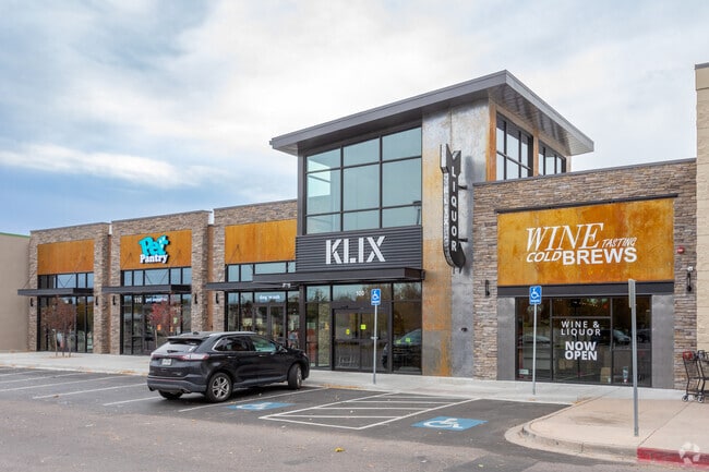
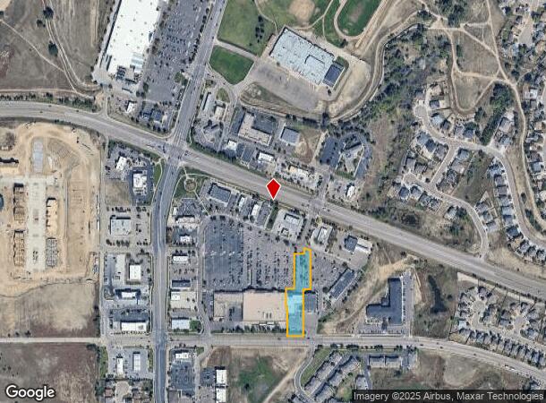
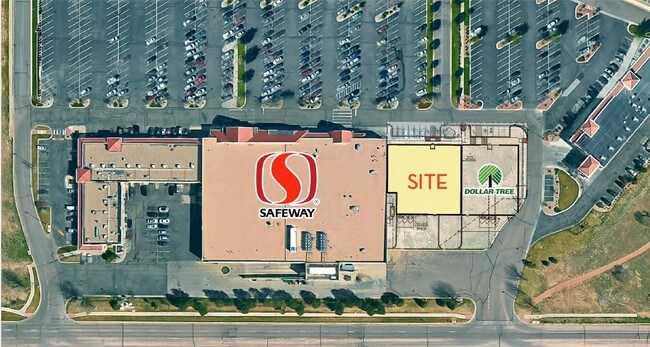
Property Record
6945 Mesa Ridge Pkwy, Fountain, CO 80817
NEARBY LISTINGS FOR SALE OR LEASE
Property Detail
6945 Mesa Ridge Pkwy
Colorado Springs, CO
Markets At Mesa Ridge Fil No 3H
55292-05-055
LOT 1 MARKETS AT MESA RIDGE FIL NO 3H
Commercialbuilding
El Paso
X
Colorado
08041C0954G
1
2024
1.47 AC
2025
Southeast
004519
Colorado Springs
11,251 SF
DEMOGRAPHICS near 6945 Mesa Ridge Pkwy
1 Mile
3 Mile
5 Mile
2024 Total Population
12,485
46,758
85,775
2029 Population
12,907
48,564
89,685
Pop Growth 2024-2029
+ 3.38%
+ 3.86%
+ 4.56%
Average Age
34
35
34
2024 Total Households
4,155
15,519
27,514
HH Growth 2024-2029
+ 3.59%
+ 4.03%
+ 4.76%
Median Household Inc
$80,075
$79,160
$79,839
Avg Household Size
3.00
3.00
3.00
2024 Avg HH Vehicles
2.00
2.00
2.00
Median Home Value
$336,379
$348,632
$345,178
Median Year Built
1996
1992
1995
Nearby Places
Map Layers
Map Styles
 Street
 Aerial
- Restaurants
- Banks
- Shops
- Fitness
- Groceries
PUBLIC TRANSPORTATION
AIRPORT
City of Colorado Springs Municipal
DRIVE
WALK
Distance
City of Colorado Springs Municipal
21 min
11.9 mi
Freight Ports
Tulsa Port Of Catoosa
DRIVE
WALK
Distance
Tulsa Port Of Catoosa
744 min
701.1 mi
SALE & LEASE HISTORY
LISTING DATE
SALE/LEASE

Sep 12, 2018
For Sale
May 14, 2021
For Lease
May 11, 2018
For Lease
Jun 06, 2018
For Lease
Nearby Properties
Address
Land Use
TOTAL SIZE
Lot Size
Zoning
Address
Land Use
TOTAL SIZE
Lot Size
Zoning
241,806 SF
937.06 AC
A-5 CAD-O
Address
Land Use
TOTAL SIZE
Lot Size
Zoning
70,473 SF
4.56 AC
Address
Land Use
TOTAL SIZE
Lot Size
Zoning
78,002 SF
7.11 AC
R-1
Address
Land Use
TOTAL SIZE
Lot Size
Zoning
80,470 SF
4.11 AC
Address
Land Use
TOTAL SIZE
Lot Size
Zoning
38,760 SF
3.96 AC
Address
Land Use
TOTAL SIZE
Lot Size
Zoning
38,015 SF
2.06 AC
Address
Land Use
TOTAL SIZE
Lot Size
Zoning
43,914 SF
9.36 AC
A-5 CAD-O
Address
Land Use
TOTAL SIZE
Lot Size
Zoning
207,858 SF
18.08 AC
C-2 R-2
Address
Land Use
TOTAL SIZE
Lot Size
Zoning
21.30 AC
Address
Land Use
TOTAL SIZE
Lot Size
Zoning
32,915 SF
2.01 AC
C-2
Address
Land Use
TOTAL SIZE
Lot Size
Zoning
19,813 SF
16.55 AC
A-5 CAD-O
Address
Land Use
TOTAL SIZE
Lot Size
Zoning
298,384 SF
23.44 AC
Address
Land Use
TOTAL SIZE
Lot Size
Zoning
250,868 SF
48.50 AC
Address
Land Use
TOTAL SIZE
Lot Size
Zoning
17,984 SF
0.92 AC
Address
Land Use
TOTAL SIZE
Lot Size
Zoning
17,119 SF
1.48 AC
Address
Land Use
TOTAL SIZE
Lot Size
Zoning
20,538 SF
1.75 AC
C-2
Address
Land Use
TOTAL SIZE
Lot Size
Zoning
158,098 SF
12.32 AC
CC CAD-O
Address
Land Use
TOTAL SIZE
Lot Size
Zoning
140,269 SF
12.17 AC
Address
Land Use
TOTAL SIZE
Lot Size
Zoning
23,056 SF
2.72 AC
RS-5000 CA
Address
Land Use
TOTAL SIZE
Lot Size
Zoning
14,073 SF
2.17 AC
Address
Land Use
TOTAL SIZE
Lot Size
Zoning
17,013 SF
2.48 AC
PBP
Address
Land Use
TOTAL SIZE
Lot Size
Zoning
30,403 SF
4.85 AC
Address
Land Use
TOTAL SIZE
Lot Size
Zoning
89,230 SF
5.25 AC
CS CAD-O
Address
Land Use
TOTAL SIZE
Lot Size
Zoning
298,384 SF
23.44 AC
Address
Land Use
TOTAL SIZE
Lot Size
Zoning
14,486 SF
2.32 AC
Address
Land Use
TOTAL SIZE
Lot Size
Zoning
5,651 SF
5 AC
NC
Address
Land Use
TOTAL SIZE
Lot Size
Zoning
15,805 SF
2.53 AC
RS-6000 CA
Address
Land Use
TOTAL SIZE
Lot Size
Zoning
864 SF
7.49 AC
Address
Land Use
TOTAL SIZE
Lot Size
Zoning
12,150 SF
1.21 AC
CS CAD-O
Address
Land Use
TOTAL SIZE
Lot Size
Zoning
646.94 AC
A-5 CAD-O
The World's #1 Commercial Real Estate Marketplace
Connect with us
© 2026 CoStar Group
The information above has been obtained from sources believed reliable. While we do not doubt its accuracy we have not verified it and make no guarantee, warranty or representation about it. It is your responsibility to independently confirm its accuracy and completeness. Any projections, opinions, assumptions, or estimates used are for example only and do not represent the current or future performance of the property. The value of this transaction to you depends on tax and other factors which should be evaluated by your tax, financial, and legal advisors. You and your advisors should conduct a careful, independent investigation of the property to determine to your satisfaction the suitability of the property for your needs.