Property Record
6946 Archibald Ave, Rancho Cucamonga, CA 91701
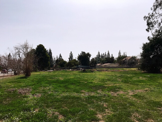
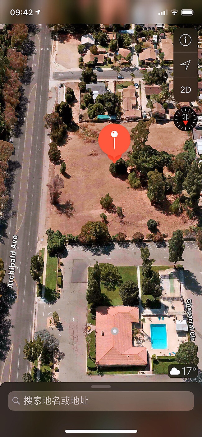

This Property Is For Sale
NEARBY LISTINGS FOR SALE OR LEASE
Property Detail
6946 Archibald Ave
Riverside-San Bernardino-Ontario, CA
Cucamonga Homestead Associatio
0202-131-62
CUC HD ASSN THAT PTN OF E 264 FT OF N 1/2 LOT 3 BLOCK 8 DESC AS BEG AT A PT 45.29 FT W FROM SE COR N 1/2 SD LOT TH N AND PARALLEL WITH E LI SD LOT 65 FT TH NWLY ALG A LI TO A PT IN A LI DRAWN PARALLEL WITH AND DIST 147 FT W OF E LI SD LOT S
Vacantlandnec
San Bernardino
A
California
06071C7890J
3
2024
1.14 AC
2025
Airport Area
002013
Inland Empire (California)
DEMOGRAPHICS near 6946 Archibald Ave
1 Mile
3 Mile
5 Mile
2024 Total Population
21,865
140,419
295,420
2029 Population
22,145
142,342
299,801
Pop Growth 2024-2029
+ 1.28%
+ 1.37%
+ 1.48%
Average Age
42
39
38
2024 Total Households
8,169
48,661
97,690
HH Growth 2024-2029
+ 1.29%
+ 1.39%
+ 1.54%
Median Household Inc
$80,186
$97,703
$95,029
Avg Household Size
2.60
2.80
2.90
2024 Avg HH Vehicles
2.00
2.00
2.00
Median Home Value
$619,096
$650,869
$657,059
Median Year Built
1979
1983
1983
Nearby Places
- Restaurants
- Banks
- Shops
- Fitness
- Groceries
PUBLIC TRANSPORTATION
COMMUTER RAIL
Rancho Cucamonga (San Bernardino Line - Southern California Regional Rail Authority (Metrolink))
DRIVE
WALK
Distance
Rancho Cucamonga (San Bernardino Line - Southern California Regional Rail Authority (Metrolink))
10 min
5.2 mi
Upland (San Bernardino Line - Southern California Regional Rail Authority (Metrolink))
DRIVE
WALK
Distance
Upland (San Bernardino Line - Southern California Regional Rail Authority (Metrolink))
12 min
5.4 mi
AIRPORT
Ontario International
DRIVE
WALK
Distance
Ontario International
12 min
5.6 mi
John Wayne/Orange County
DRIVE
WALK
Distance
John Wayne/Orange County
60 min
49.1 mi
Nearby Properties
Address
Land Use
TOTAL SIZE
Lot Size
Zoning
Address
Land Use
TOTAL SIZE
Lot Size
Zoning
293,860 SF
16.10 AC
Address
Land Use
TOTAL SIZE
Lot Size
Zoning
190,724 SF
10.69 AC
Address
Land Use
TOTAL SIZE
Lot Size
Zoning
468,682 SF
19.40 AC
Address
Land Use
TOTAL SIZE
Lot Size
Zoning
174,092 SF
4.42 AC
Address
Land Use
TOTAL SIZE
Lot Size
Zoning
251,645 SF
4.50 AC
Address
Land Use
TOTAL SIZE
Lot Size
Zoning
340,104 SF
8.95 AC
Address
Land Use
TOTAL SIZE
Lot Size
Zoning
249,672 SF
13.80 AC
Address
Land Use
TOTAL SIZE
Lot Size
Zoning
405,970 SF
19.23 AC
Address
Land Use
TOTAL SIZE
Lot Size
Zoning
139,059 SF
20.83 AC
Address
Land Use
TOTAL SIZE
Lot Size
Zoning
122,563 SF
5.76 AC
Address
Land Use
TOTAL SIZE
Lot Size
Zoning
225,727 SF
7.18 AC
Address
Land Use
TOTAL SIZE
Lot Size
Zoning
354,616 SF
20.07 AC
Address
Land Use
TOTAL SIZE
Lot Size
Zoning
131,190 SF
6.71 AC
Address
Land Use
TOTAL SIZE
Lot Size
Zoning
468,410 SF
22.71 AC
Address
Land Use
TOTAL SIZE
Lot Size
Zoning
443,300 SF
23.06 AC
Address
Land Use
TOTAL SIZE
Lot Size
Zoning
127,559 SF
5.63 AC
Address
Land Use
TOTAL SIZE
Lot Size
Zoning
324,131 SF
19.81 AC
Address
Land Use
TOTAL SIZE
Lot Size
Zoning
161,555 SF
8.25 AC
Address
Land Use
TOTAL SIZE
Lot Size
Zoning
95,240 SF
8.42 AC
Address
Land Use
TOTAL SIZE
Lot Size
Zoning
99,345 SF
5.15 AC
Address
Land Use
TOTAL SIZE
Lot Size
Zoning
63,862 SF
4.77 AC
Address
Land Use
TOTAL SIZE
Lot Size
Zoning
171,446 SF
10.88 AC
Address
Land Use
TOTAL SIZE
Lot Size
Zoning
133,847 SF
7.52 AC
Address
Land Use
TOTAL SIZE
Lot Size
Zoning
102,516 SF
4.88 AC
Address
Land Use
TOTAL SIZE
Lot Size
Zoning
79,319 SF
4.47 AC
Address
Land Use
TOTAL SIZE
Lot Size
Zoning
54,166 SF
4.60 AC
Address
Land Use
TOTAL SIZE
Lot Size
Zoning
110,442 SF
4.60 AC
Address
Land Use
TOTAL SIZE
Lot Size
Zoning
54,444 SF
4.71 AC
Address
Land Use
TOTAL SIZE
Lot Size
Zoning
175,624 SF
8.20 AC
Address
Land Use
TOTAL SIZE
Lot Size
Zoning
101,796 SF
8.82 AC
The World's #1 Commercial Real Estate Marketplace
Connect with us
© 2025 CoStar Group
The information above has been obtained from sources believed reliable. While we do not doubt its accuracy we have not verified it and make no guarantee, warranty or representation about it. It is your responsibility to independently confirm its accuracy and completeness. Any projections, opinions, assumptions, or estimates used are for example only and do not represent the current or future performance of the property. The value of this transaction to you depends on tax and other factors which should be evaluated by your tax, financial, and legal advisors. You and your advisors should conduct a careful, independent investigation of the property to determine to your satisfaction the suitability of the property for your needs.