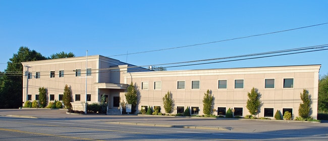
Property Record
6946 Post Rd, North Kingstown, RI 02852


Current Lease Availabilities
Property Detail
6946 Post Rd
Commercialbuilding
Washington
PR
Rhode Island
B and X Area of moderate flood hazard, usually the area between the limits of the 100-year and 500-year floods.
1.80 AC
2025
Washington County
2025
Providence
050103
Providence-Warwick, RI-MA
30,775 SF
NKIN-000146-000066
NEARBY LISTINGS FOR SALE OR LEASE
DEMOGRAPHICS near 6946 Post Rd
1 mile
3 mile
5 mile
2025 Total Population
4,560
20,178
43,596
2030 Population
4,446
19,972
43,350
Pop Growth 2025-2030
(2.50%)
(1.02%)
(0.56%)
Average Age
43
44
44
2025 Total Households
2,096
8,315
17,773
HH Growth 2025-2030
(2.86%)
(1.47%)
(0.83%)
Median Household Inc
$97,806
$109,818
$120,186
Avg Household Size
2.10
2.40
2.40
2025 Avg HH Vehicles
2.00
2.00
2.00
Median Home Value
$363,061
$491,515
$593,129
Median Year Built
1970
1968
1971
Nearby Places
Map Layers
Map Styles
 Street
 Aerial
Layers
 Traffic
 Biking
Places
Listings with unknown addresses are not visible on the map
- Restaurants
- Banks
- Shops
- Fitness
- Groceries
PUBLIC TRANSPORTATION
COMMUTER RAIL
Wickford Junction (Providence/Stoughton Line - MBTA)
Drive
Walk
Distance
Wickford Junction (Providence/Stoughton Line - MBTA)
10 min
5.0 mi
AIRPORT
Rhode Island Tf Green International
Drive
Walk
Distance
Rhode Island Tf Green International
23 min
13.0 mi
Freight Ports
Port of Davisville, RI
Drive
Walk
Distance
Port of Davisville, RI
7 min
2.9 mi
Nearby Properties
Address
Land Use
TOTAL SIZE
Lot Size
Zoning
Address
Land Use
TOTAL SIZE
Lot Size
Zoning
556,793 SF
56.95 AC
QBPD
Address
Land Use
TOTAL SIZE
Lot Size
Zoning
122,785 SF
43.80 AC
QBPD
Address
Land Use
TOTAL SIZE
Lot Size
Zoning
72.28 AC
QBPD
Address
Land Use
TOTAL SIZE
Lot Size
Zoning
175.70 AC
QBPD
Address
Land Use
TOTAL SIZE
Lot Size
Zoning
32.58 AC
QBPD
Address
Land Use
TOTAL SIZE
Lot Size
Zoning
461,128 SF
21.54 AC
QBPD
Address
Land Use
TOTAL SIZE
Lot Size
Zoning
39.16 AC
QBPD
Address
Land Use
TOTAL SIZE
Lot Size
Zoning
61,984 SF
14.46 AC
QBPD
Address
Land Use
TOTAL SIZE
Lot Size
Zoning
83.30 AC
F1
Address
Land Use
TOTAL SIZE
Lot Size
Zoning
20.43 AC
MUPD
Address
Land Use
TOTAL SIZE
Lot Size
Zoning
466,871 SF
17.96 AC
QBPD
Address
Land Use
TOTAL SIZE
Lot Size
Zoning
8.10 AC
PR
Address
Land Use
TOTAL SIZE
Lot Size
Zoning
28,800 SF
18.70 AC
QBPD
Address
Land Use
TOTAL SIZE
Lot Size
Zoning
63,014 SF
167.39 AC
QBPD
Address
Land Use
TOTAL SIZE
Lot Size
Zoning
161,263 SF
61.75 AC
R30
Address
Land Use
TOTAL SIZE
Lot Size
Zoning
196,759 SF
33.67 AC
QBPD
Address
Land Use
TOTAL SIZE
Lot Size
Zoning
27.90 AC
QBPD
Address
Land Use
TOTAL SIZE
Lot Size
Zoning
121,016 SF
13.50 AC
QBPD
Address
Land Use
TOTAL SIZE
Lot Size
Zoning
4,288 SF
33.30 AC
PVD
Address
Land Use
TOTAL SIZE
Lot Size
Zoning
3,417 SF
7.13 AC
PR
Address
Land Use
TOTAL SIZE
Lot Size
Zoning
8.73 AC
PR
Address
Land Use
TOTAL SIZE
Lot Size
Zoning
63.69 AC
LI
Address
Land Use
TOTAL SIZE
Lot Size
Zoning
141,701 SF
12 AC
WJ
Address
Land Use
TOTAL SIZE
Lot Size
Zoning
107,212 SF
18.50 AC
R10
Address
Land Use
TOTAL SIZE
Lot Size
Zoning
137,323 SF
22.84 AC
PR
Address
Land Use
TOTAL SIZE
Lot Size
Zoning
97,308 SF
9.36 AC
P
Address
Land Use
TOTAL SIZE
Lot Size
Zoning
125,393 SF
15.33 AC
GB
Address
Land Use
TOTAL SIZE
Lot Size
Zoning
83.12 AC
MLIO
Address
Land Use
TOTAL SIZE
Lot Size
Zoning
92,700 SF
9.90 AC
QBPD
Address
Land Use
TOTAL SIZE
Lot Size
Zoning
8.92 AC
PR
The World's #1 Commercial Real Estate Marketplace
Connect with us
© 2026 CoStar Group
The information above has been obtained from sources believed reliable. While we do not doubt its accuracy we have not verified it and make no guarantee, warranty or representation about it. It is your responsibility to independently confirm its accuracy and completeness. Any projections, opinions, assumptions, or estimates used are for example only and do not represent the current or future performance of the property. The value of this transaction to you depends on tax and other factors which should be evaluated by your tax, financial, and legal advisors. You and your advisors should conduct a careful, independent investigation of the property to determine to your satisfaction the suitability of the property for your needs.