Property Record
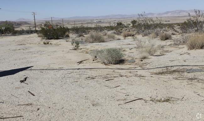
69464 29 Palms Hwy, Twentynine Palms, CA 92277
NEARBY LISTINGS FOR SALE OR LEASE
Property Detail
69464 29 Palms Hwy
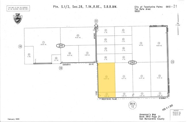
0613-212-12
S 250 FT W 1/2 SW 1/4 SE 1/4 SEC 28 TP 1N R 8E EX E 8 FT AND EX RD AND EX HGWY
Vacantlandnec
San Bernardino
X
California
06071C8175H
15.04 AC
2024
Twentynine Palms
2025
Inland Empire (California)
010422
Riverside-San Bernardino-Ontario, CA
DEMOGRAPHICS near 69464 29 Palms Hwy
1 Mile
3 Mile
5 Mile
2024 Total Population
772
2,371
9,568
2029 Population
800
2,455
9,907
Pop Growth 2024-2029
+ 3.63%
+ 3.54%
+ 3.54%
Average Age
42
40
38
2024 Total Households
321
979
3,871
HH Growth 2024-2029
+ 3.74%
+ 3.47%
+ 3.54%
Median Household Inc
$81,090
$70,095
$57,249
Avg Household Size
2.40
2.40
2.50
2024 Avg HH Vehicles
2.00
2.00
2.00
Median Home Value
$367,741
$278,394
$200,659
Median Year Built
1979
1980
1980
Nearby Places
- Restaurants
- Banks
- Shops
- Fitness
- Groceries
PUBLIC TRANSPORTATION
AIRPORT
Palm Springs International
DRIVE
WALK
Distance
Palm Springs International
66 min
46.9 mi
Freight Ports
Port of San Diego
DRIVE
WALK
Distance
Port of San Diego
195 min
155.0 mi
Nearby Properties
Address
Land Use
TOTAL SIZE
Lot Size
Zoning
Address
Land Use
TOTAL SIZE
Lot Size
Zoning
49,866 SF
3.63 AC
Address
Land Use
TOTAL SIZE
Lot Size
Zoning
79,214 SF
4.93 AC
Address
Land Use
TOTAL SIZE
Lot Size
Zoning
16,000 SF
2.78 AC
Address
Land Use
TOTAL SIZE
Lot Size
Zoning
2,121 SF
0.32 AC
Address
Land Use
TOTAL SIZE
Lot Size
Zoning
23,514 SF
111 AC
Address
Land Use
TOTAL SIZE
Lot Size
Zoning
91.66 AC
Address
Land Use
TOTAL SIZE
Lot Size
Zoning
7,886 SF
6.43 AC
Address
Land Use
TOTAL SIZE
Lot Size
Zoning
218.80 AC
RC
Address
Land Use
TOTAL SIZE
Lot Size
Zoning
19,902 SF
1.32 AC
Address
Land Use
TOTAL SIZE
Lot Size
Zoning
2,565 SF
0.56 AC
Address
Land Use
TOTAL SIZE
Lot Size
Zoning
1,767 SF
0.57 AC
Address
Land Use
TOTAL SIZE
Lot Size
Zoning
2,171 SF
20 AC
Address
Land Use
TOTAL SIZE
Lot Size
Zoning
2,200 SF
0.60 AC
Address
Land Use
TOTAL SIZE
Lot Size
Zoning
3,908 SF
2.12 AC
Address
Land Use
TOTAL SIZE
Lot Size
Zoning
18.03 AC
Address
Land Use
TOTAL SIZE
Lot Size
Zoning
316.97 AC
Address
Land Use
TOTAL SIZE
Lot Size
Zoning
4,032 SF
1.81 AC
Address
Land Use
TOTAL SIZE
Lot Size
Zoning
1,866 SF
17.88 AC
Address
Land Use
TOTAL SIZE
Lot Size
Zoning
Address
Land Use
TOTAL SIZE
Lot Size
Zoning
3,128 SF
1.80 AC
Address
Land Use
TOTAL SIZE
Lot Size
Zoning
70.82 AC
Address
Land Use
TOTAL SIZE
Lot Size
Zoning
720 SF
40 AC
Address
Land Use
TOTAL SIZE
Lot Size
Zoning
4.93 AC
Address
Land Use
TOTAL SIZE
Lot Size
Zoning
1,880 SF
2.25 AC
Address
Land Use
TOTAL SIZE
Lot Size
Zoning
73.31 AC
Address
Land Use
TOTAL SIZE
Lot Size
Zoning
1,200 SF
0.55 AC
C
Address
Land Use
TOTAL SIZE
Lot Size
Zoning
532 SF
20 AC
Address
Land Use
TOTAL SIZE
Lot Size
Zoning
151.53 AC
Address
Land Use
TOTAL SIZE
Lot Size
Zoning
5,902 SF
8.89 AC
The World's #1 Commercial Real Estate Marketplace
Connect with us
© 2025 CoStar Group
The information above has been obtained from sources believed reliable. While we do not doubt its accuracy we have not verified it and make no guarantee, warranty or representation about it. It is your responsibility to independently confirm its accuracy and completeness. Any projections, opinions, assumptions, or estimates used are for example only and do not represent the current or future performance of the property. The value of this transaction to you depends on tax and other factors which should be evaluated by your tax, financial, and legal advisors. You and your advisors should conduct a careful, independent investigation of the property to determine to your satisfaction the suitability of the property for your needs.