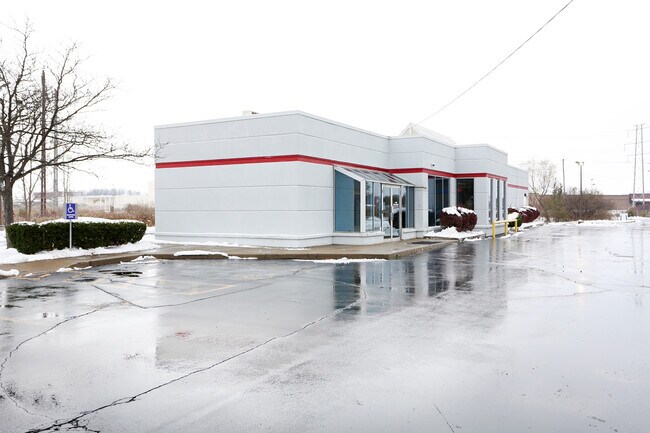
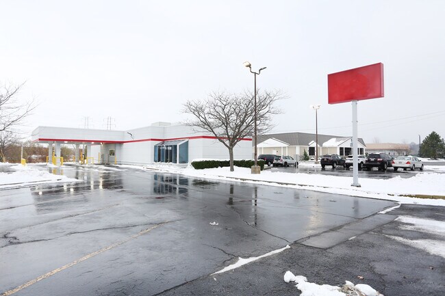
Property Record
6947 Williams Rd, Niagara Falls, NY 14304


Property Detail
6947 Williams Rd
Buffalo-Cheektowaga, NY
WENDY'S 8/92 10919 175,000
294000-161-000-0001-042-000
Niagara
Financialbuilding
New York
B and X Area of moderate flood hazard, usually the area between the limits of the 100-year and 500-year floods.
42.000
2025
1.19 AC
2025
Outlying Niagara County
022714
Buffalo/Niagara Falls
3,441 SF
NEARBY LISTINGS FOR SALE OR LEASE
DEMOGRAPHICS near 6947 Williams Rd
1 mile
3 mile
5 mile
2025 Total Population
5,709
31,203
82,552
2030 Population
5,672
30,895
81,756
Pop Growth 2025-2030
(0.65%)
(0.99%)
(0.96%)
Average Age
46
44
43
2025 Total Households
2,819
14,067
35,743
HH Growth 2025-2030
(0.71%)
(1.02%)
(1.07%)
Median Household Inc
$55,914
$69,278
$71,006
Avg Household Size
2.00
2.20
2.20
2025 Avg HH Vehicles
2.00
2.00
2.00
Median Home Value
$159,498
$176,825
$194,179
Median Year Built
1969
1960
1958
Nearby Places
Map Layers
Map Styles
 Street
 Aerial
Layers
 Traffic
 Biking
Places
Listings with unknown addresses are not visible on the map
- Restaurants
- Banks
- Shops
- Fitness
- Groceries
PUBLIC TRANSPORTATION
COMMUTER RAIL
Drive
Walk
Distance
14 min
7.4 mi
AIRPORT
Niagara Falls International
Drive
Walk
Distance
Niagara Falls International
3 min
1.3 mi
Buffalo Niagara International
Drive
Walk
Distance
Buffalo Niagara International
33 min
17.7 mi
SALE & LEASE HISTORY
LISTING DATE
SALE/LEASE

Sep 25, 2016
For Lease
Feb 27, 2020
For Sale
Apr 13, 2018
For Sale
Nearby Properties
Address
Land Use
TOTAL SIZE
Lot Size
Zoning
Address
Land Use
TOTAL SIZE
Lot Size
Zoning
22.40 AC
INS
Address
Land Use
TOTAL SIZE
Lot Size
Zoning
160.52 AC
06 - INDUS
Address
Land Use
TOTAL SIZE
Lot Size
Zoning
37.85 AC
06 - INDUS
Address
Land Use
TOTAL SIZE
Lot Size
Zoning
3,600 SF
72.50 AC
Address
Land Use
TOTAL SIZE
Lot Size
Zoning
586,059 SF
34.85 AC
05 - COMME
Address
Land Use
TOTAL SIZE
Lot Size
Zoning
15,240 SF
5.20 AC
06 - INDUS
Address
Land Use
TOTAL SIZE
Lot Size
Zoning
17,941 SF
4.41 AC
OS
Address
Land Use
TOTAL SIZE
Lot Size
Zoning
0.30 AC
R1-C
Address
Land Use
TOTAL SIZE
Lot Size
Zoning
234,072 SF
35.57 AC
05 - COMME
Address
Land Use
TOTAL SIZE
Lot Size
Zoning
131,846 SF
14.66 AC
05 - COMME
Address
Land Use
TOTAL SIZE
Lot Size
Zoning
200.67 AC
06 - INDUS
Address
Land Use
TOTAL SIZE
Lot Size
Zoning
58,226 SF
16.40 AC
Address
Land Use
TOTAL SIZE
Lot Size
Zoning
1,200 SF
49.80 AC
05 - COMME
Address
Land Use
TOTAL SIZE
Lot Size
Zoning
1,600 SF
34.80 AC
06 - INDUS
Address
Land Use
TOTAL SIZE
Lot Size
Zoning
105,401 SF
6.22 AC
05 - COMME
Address
Land Use
TOTAL SIZE
Lot Size
Zoning
110,174 SF
20.92 AC
05 - COMME
Address
Land Use
TOTAL SIZE
Lot Size
Zoning
Address
Land Use
TOTAL SIZE
Lot Size
Zoning
211,484 SF
18.30 AC
C3
Address
Land Use
TOTAL SIZE
Lot Size
Zoning
11,788 SF
13.91 AC
03 - MULTI
Address
Land Use
TOTAL SIZE
Lot Size
Zoning
5,674 SF
0.06 AC
05 - COMME
Address
Land Use
TOTAL SIZE
Lot Size
Zoning
22,874 SF
19.07 AC
02 - SINGL
Address
Land Use
TOTAL SIZE
Lot Size
Zoning
10,647 SF
14 AC
C3
Address
Land Use
TOTAL SIZE
Lot Size
Zoning
33.14 AC
C3
Address
Land Use
TOTAL SIZE
Lot Size
Zoning
720 SF
19.45 AC
05 - COMME
Address
Land Use
TOTAL SIZE
Lot Size
Zoning
26,024 SF
3.30 AC
05 - COMME
Address
Land Use
TOTAL SIZE
Lot Size
Zoning
6,369 SF
12.58 AC
C3
Address
Land Use
TOTAL SIZE
Lot Size
Zoning
82,528 SF
3 AC
Address
Land Use
TOTAL SIZE
Lot Size
Zoning
6,289 SF
19.08 AC
05 - COMME
Address
Land Use
TOTAL SIZE
Lot Size
Zoning
75,357 SF
25 AC
R1D
Address
Land Use
TOTAL SIZE
Lot Size
Zoning
3,204 SF
1.55 AC
05 - COMME
The World's #1 Commercial Real Estate Marketplace
Connect with us
© 2026 CoStar Group
The information above has been obtained from sources believed reliable. While we do not doubt its accuracy we have not verified it and make no guarantee, warranty or representation about it. It is your responsibility to independently confirm its accuracy and completeness. Any projections, opinions, assumptions, or estimates used are for example only and do not represent the current or future performance of the property. The value of this transaction to you depends on tax and other factors which should be evaluated by your tax, financial, and legal advisors. You and your advisors should conduct a careful, independent investigation of the property to determine to your satisfaction the suitability of the property for your needs.