Property Record
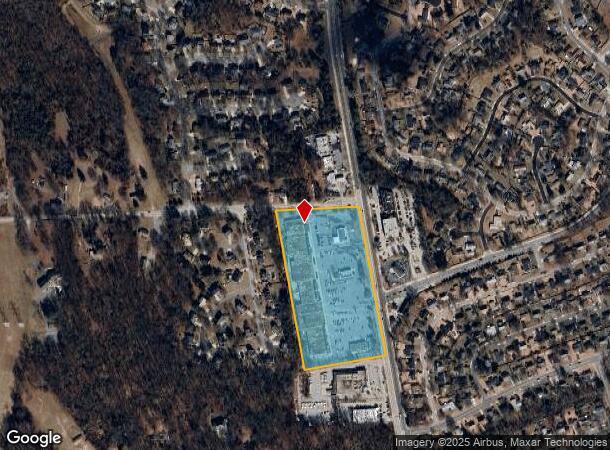
6948 Laurel Bowie Rd, Bowie, MD 20715
NEARBY LISTINGS FOR SALE OR LEASE
-
-
View all Bowie listings for lease on LoopNet.com
Property Detail
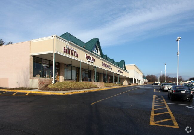
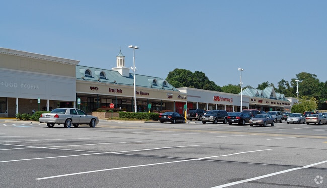
6948 Laurel Bowie Rd
14-1640762
(PT IMPS RAZED 11/1/08)
Regionalshoppingcenterormallwithanchorstore
Prince George's
X
Maryland
24033C0160E
10.79 AC
2024
Bowie
2025
Washington, DC
800409
Washington-Arlington-Alexandria, DC-VA-MD-WV
102,762 SF
DEMOGRAPHICS near 6948 Laurel Bowie Rd
1 Mile
3 Mile
5 Mile
2024 Total Population
7,978
52,566
123,226
2029 Population
7,715
51,301
121,478
Pop Growth 2024-2029
(3.30%)
(2.41%)
(1.42%)
Average Age
43
42
41
2024 Total Households
2,703
17,074
41,940
HH Growth 2024-2029
(3.40%)
(2.50%)
(1.35%)
Median Household Inc
$132,273
$140,603
$128,273
Avg Household Size
2.80
2.90
2.80
2024 Avg HH Vehicles
2.00
2.00
2.00
Median Home Value
$397,400
$440,396
$444,501
Median Year Built
1966
1981
1986
Nearby Places
Map Layers
Map Styles
 Street
 Aerial
- Restaurants
- Banks
- Shops
- Fitness
- Groceries
PUBLIC TRANSPORTATION
COMMUTER RAIL
Bowie State Marc Sb (PENN - WASHINGTON - Maryland Transit Administration)
DRIVE
WALK
Distance
Bowie State Marc Sb (PENN - WASHINGTON - Maryland Transit Administration)
5 min
2.7 mi
Bowie State Marc Nb (PENN - WASHINGTON - Maryland Transit Administration)
DRIVE
WALK
Distance
Bowie State Marc Nb (PENN - WASHINGTON - Maryland Transit Administration)
6 min
2.8 mi
AIRPORT
Baltimore/Washington International Thurgood Marshall
DRIVE
WALK
Distance
Baltimore/Washington International Thurgood Marshall
34 min
22.4 mi
Ronald Reagan Washington Ntl
DRIVE
WALK
Distance
Ronald Reagan Washington Ntl
36 min
24.1 mi
Freight Ports
Port of Baltimore
DRIVE
WALK
Distance
Port of Baltimore
43 min
28.4 mi
SALE & LEASE HISTORY
LISTING DATE
SALE/LEASE

Sep 25, 2016
For Lease
Nearby Properties
Address
Land Use
TOTAL SIZE
Lot Size
Zoning
Address
Land Use
TOTAL SIZE
Lot Size
Zoning
286 SF
13.08 AC
RMF20
Address
Land Use
TOTAL SIZE
Lot Size
Zoning
104,397 SF
27.71 AC
AG
Address
Land Use
TOTAL SIZE
Lot Size
Zoning
80,321 SF
11.78 AC
CGO
Address
Land Use
TOTAL SIZE
Lot Size
Zoning
227.10 AC
NAC
Address
Land Use
TOTAL SIZE
Lot Size
Zoning
287,439 SF
19.97 AC
CGO
Address
Land Use
TOTAL SIZE
Lot Size
Zoning
1,296 SF
10.78 AC
RMF20
Address
Land Use
TOTAL SIZE
Lot Size
Zoning
101,475 SF
11.17 AC
CGO
Address
Land Use
TOTAL SIZE
Lot Size
Zoning
166,720 SF
8.72 AC
TACE
Address
Land Use
TOTAL SIZE
Lot Size
Zoning
170,641 SF
4.30 AC
IE
Address
Land Use
TOTAL SIZE
Lot Size
Zoning
124,984 SF
10.30 AC
TACE
Address
Land Use
TOTAL SIZE
Lot Size
Zoning
47,132 SF
3.53 AC
LMXC
Address
Land Use
TOTAL SIZE
Lot Size
Zoning
65,928 SF
6.61 AC
TACC
Address
Land Use
TOTAL SIZE
Lot Size
Zoning
175,036 SF
9.44 AC
TACE
Address
Land Use
TOTAL SIZE
Lot Size
Zoning
115,512 SF
12.82 AC
LMXC
Address
Land Use
TOTAL SIZE
Lot Size
Zoning
60,600 SF
6 AC
RR
Address
Land Use
TOTAL SIZE
Lot Size
Zoning
129,800 SF
3.13 AC
TACE
Address
Land Use
TOTAL SIZE
Lot Size
Zoning
42,120 SF
9.33 AC
LCD
Address
Land Use
TOTAL SIZE
Lot Size
Zoning
45,644 SF
3.90 AC
RR
Address
Land Use
TOTAL SIZE
Lot Size
Zoning
87,104 SF
3.52 AC
TACE
Address
Land Use
TOTAL SIZE
Lot Size
Zoning
50,000 SF
2.76 AC
RR
Address
Land Use
TOTAL SIZE
Lot Size
Zoning
80,970 SF
16.06 AC
RSF65
Address
Land Use
TOTAL SIZE
Lot Size
Zoning
315,825 SF
24.80 AC
IE
Address
Land Use
TOTAL SIZE
Lot Size
Zoning
24,864 SF
29.51 AC
RSF95
Address
Land Use
TOTAL SIZE
Lot Size
Zoning
32.28 AC
ROS
Address
Land Use
TOTAL SIZE
Lot Size
Zoning
12.75 AC
TACE
Address
Land Use
TOTAL SIZE
Lot Size
Zoning
72,749 SF
9.93 AC
RR
Address
Land Use
TOTAL SIZE
Lot Size
Zoning
62,444 SF
18.50 AC
AG
Address
Land Use
TOTAL SIZE
Lot Size
Zoning
66,398 SF
2.91 AC
CS
Address
Land Use
TOTAL SIZE
Lot Size
Zoning
90,544 SF
8 AC
RSF95
The World's #1 Commercial Real Estate Marketplace
Connect with us
© 2025 CoStar Group
The information above has been obtained from sources believed reliable. While we do not doubt its accuracy we have not verified it and make no guarantee, warranty or representation about it. It is your responsibility to independently confirm its accuracy and completeness. Any projections, opinions, assumptions, or estimates used are for example only and do not represent the current or future performance of the property. The value of this transaction to you depends on tax and other factors which should be evaluated by your tax, financial, and legal advisors. You and your advisors should conduct a careful, independent investigation of the property to determine to your satisfaction the suitability of the property for your needs.