Property Record
695 Pearidge Rd, Willow Spring, NC 27592

Property Detail
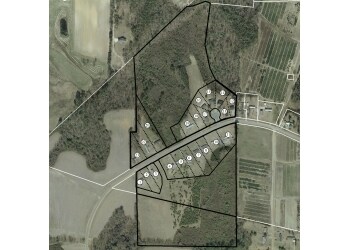
695 Pearidge Rd
Raleigh-Cary, NC
LT 3 78/63
13A01030
JOHNSTON
Realpropertynec
North Carolina
MHP
3
B and X Area of moderate flood hazard, usually the area between the limits of the 100-year and 500-year floods.
3.16 AC
2025
Johnston County
2025
Raleigh/Durham
041508
NEARBY LISTINGS FOR SALE OR LEASE
DEMOGRAPHICS near 695 Pearidge Rd
1 mile
3 mile
5 mile
2024 Total Population
910
13,194
39,665
2029 Population
1,005
14,574
43,958
Pop Growth 2024-2029
+ 10.44%
+ 10.46%
+ 10.82%
Average Age
39
39
40
2024 Total Households
328
4,832
14,348
HH Growth 2024-2029
+ 10.37%
+ 10.47%
+ 10.93%
Median Household Inc
$66,250
$63,883
$83,112
Avg Household Size
2.70
2.70
2.70
2024 Avg HH Vehicles
2.00
2.00
2.00
Median Home Value
$315,540
$329,353
$370,568
Median Year Built
1999
1999
2003
Nearby Places
Map Layers
Map Styles
 Street
 Aerial
Transit
 Traffic
 Biking
Places
Listings with unknown addresses are not visible on the map
- Restaurants
- Banks
- Shops
- Fitness
- Groceries
PUBLIC TRANSPORTATION
AIRPORT
Raleigh-Durham International
Drive
Walk
Distance
Raleigh-Durham International
51 min
32.1 mi
Freight Ports
Port of Wilmington
Drive
Walk
Distance
Port of Wilmington
142 min
119.8 mi
Nearby Properties
Address
Land Use
TOTAL SIZE
Lot Size
Zoning
Address
Land Use
TOTAL SIZE
Lot Size
Zoning
38,728 SF
9.99 AC
RA-30
Address
Land Use
TOTAL SIZE
Lot Size
Zoning
89,919 SF
15.77 AC
OI
Address
Land Use
TOTAL SIZE
Lot Size
Zoning
76.04 AC
R-6
Address
Land Use
TOTAL SIZE
Lot Size
Zoning
47,048 SF
12.46 AC
Address
Land Use
TOTAL SIZE
Lot Size
Zoning
52.31 AC
R-6
Address
Land Use
TOTAL SIZE
Lot Size
Zoning
30,425 SF
3.26 AC
R-30
Address
Land Use
TOTAL SIZE
Lot Size
Zoning
33.10 AC
R-6
Address
Land Use
TOTAL SIZE
Lot Size
Zoning
11,104 SF
15.21 AC
RAG
Address
Land Use
TOTAL SIZE
Lot Size
Zoning
14,416 SF
1.61 AC
GC
Address
Land Use
TOTAL SIZE
Lot Size
Zoning
14,480 SF
5.10 AC
O&I
Address
Land Use
TOTAL SIZE
Lot Size
Zoning
96,923 SF
18.97 AC
Address
Land Use
TOTAL SIZE
Lot Size
Zoning
1,040 SF
2.24 AC
R10
Address
Land Use
TOTAL SIZE
Lot Size
Zoning
22,364 SF
2 AC
R10
Address
Land Use
TOTAL SIZE
Lot Size
Zoning
3,000 SF
3.04 AC
COL
Address
Land Use
TOTAL SIZE
Lot Size
Zoning
9,082 SF
52.51 AC
RAG
Address
Land Use
TOTAL SIZE
Lot Size
Zoning
9,935 SF
0.76 AC
GC
Address
Land Use
TOTAL SIZE
Lot Size
Zoning
4,410 SF
1.18 AC
GC
Address
Land Use
TOTAL SIZE
Lot Size
Zoning
12,000 SF
5.41 AC
CU-HC
Address
Land Use
TOTAL SIZE
Lot Size
Zoning
25,156 SF
5.17 AC
RA30
Address
Land Use
TOTAL SIZE
Lot Size
Zoning
9,217 SF
1.44 AC
GC
Address
Land Use
TOTAL SIZE
Lot Size
Zoning
7,924 SF
4 AC
R-30
Address
Land Use
TOTAL SIZE
Lot Size
Zoning
2,194 SF
96.59 AC
RAG
Address
Land Use
TOTAL SIZE
Lot Size
Zoning
24.36 AC
RA30
Address
Land Use
TOTAL SIZE
Lot Size
Zoning
8,546 SF
1.43 AC
Address
Land Use
TOTAL SIZE
Lot Size
Zoning
19.63 AC
O&I
Address
Land Use
TOTAL SIZE
Lot Size
Zoning
8,400 SF
0.52 AC
GC
Address
Land Use
TOTAL SIZE
Lot Size
Zoning
9,336 SF
14.26 AC
R15
Address
Land Use
TOTAL SIZE
Lot Size
Zoning
3,333 SF
58.92 AC
RAG
Address
Land Use
TOTAL SIZE
Lot Size
Zoning
960 SF
69.95 AC
R-30
Address
Land Use
TOTAL SIZE
Lot Size
Zoning
2,808 SF
0.70 AC
The World's #1 Commercial Real Estate Marketplace
Connect with us
© 2026 CoStar Group
The information above has been obtained from sources believed reliable. While we do not doubt its accuracy we have not verified it and make no guarantee, warranty or representation about it. It is your responsibility to independently confirm its accuracy and completeness. Any projections, opinions, assumptions, or estimates used are for example only and do not represent the current or future performance of the property. The value of this transaction to you depends on tax and other factors which should be evaluated by your tax, financial, and legal advisors. You and your advisors should conduct a careful, independent investigation of the property to determine to your satisfaction the suitability of the property for your needs.