Property Record
6950 Eubanks St, Frisco, TX 75034


Property Detail
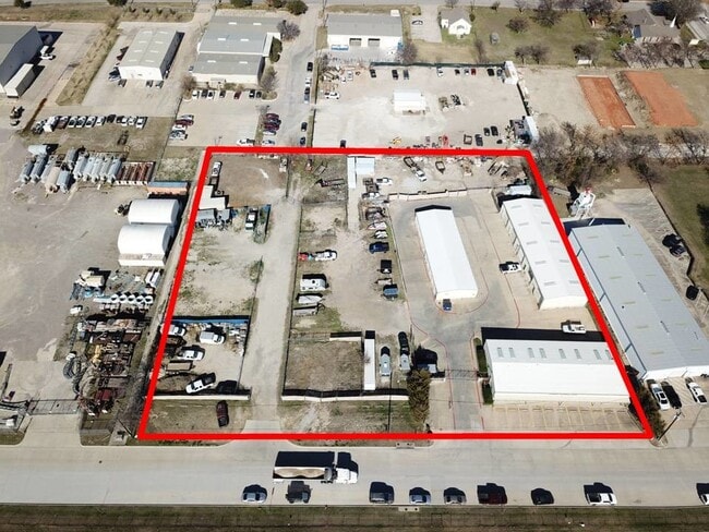
6950 Eubanks St
Dallas-Fort Worth-Arlington, TX
ABS A1004 W B WATKINS SURVEY, TRACT 20, 2.8859 ACRES
R-7004-000-0200-1
COLLIN
Commercialnec
Texas
B and X Area of moderate flood hazard, usually the area between the limits of the 100-year and 500-year floods.
20
2025
2.89 AC
2025
Frisco/The Colony
030410
Dallas/Ft Worth
12,900 SF
NEARBY LISTINGS FOR SALE OR LEASE
DEMOGRAPHICS near 6950 Eubanks St
1 mile
3 mile
5 mile
2025 Total Population
11,666
106,694
303,361
2030 Population
13,499
121,326
344,222
Pop Growth 2025-2030
+ 15.71%
+ 13.71%
+ 13.47%
Average Age
38
37
37
2025 Total Households
5,148
40,437
107,670
HH Growth 2025-2030
+ 16.16%
+ 14.27%
+ 13.89%
Median Household Inc
$83,619
$124,533
$138,508
Avg Household Size
2.20
2.60
2.80
2025 Avg HH Vehicles
2.00
2.00
2.00
Median Home Value
$506,549
$664,697
$644,790
Median Year Built
2003
2007
2008
Nearby Places
Map Layers
Map Styles
 Street
 Aerial
Layers
 Traffic
 Biking
Places
Listings with unknown addresses are not visible on the map
- Restaurants
- Banks
- Shops
- Fitness
- Groceries
PUBLIC TRANSPORTATION
AIRPORT
Dallas Love Field
Drive
Walk
Distance
Dallas Love Field
33 min
24.6 mi
Dallas-Fort Worth International
Drive
Walk
Distance
Dallas-Fort Worth International
32 min
25.4 mi
SALE & LEASE HISTORY
LISTING DATE
SALE/LEASE

Mar 14, 2025
For Lease
Aug 23, 2024
For Sale
Nearby Properties
Address
Land Use
TOTAL SIZE
Lot Size
Zoning
Address
Land Use
TOTAL SIZE
Lot Size
Zoning
525,388 SF
5.01 AC
Address
Land Use
TOTAL SIZE
Lot Size
Zoning
343,317 SF
17.17 AC
Address
Land Use
TOTAL SIZE
Lot Size
Zoning
358,447 SF
40.21 AC
Address
Land Use
TOTAL SIZE
Lot Size
Zoning
975,081 SF
15.33 AC
Address
Land Use
TOTAL SIZE
Lot Size
Zoning
525,405 SF
5.09 AC
Address
Land Use
TOTAL SIZE
Lot Size
Zoning
741,280 SF
90.87 AC
Address
Land Use
TOTAL SIZE
Lot Size
Zoning
358,496 SF
2.49 AC
Address
Land Use
TOTAL SIZE
Lot Size
Zoning
325,179 SF
4.74 AC
COMM
Address
Land Use
TOTAL SIZE
Lot Size
Zoning
458,757 SF
83.22 AC
Address
Land Use
TOTAL SIZE
Lot Size
Zoning
318,230 SF
5.52 AC
Address
Land Use
TOTAL SIZE
Lot Size
Zoning
761,346 SF
75.86 AC
Address
Land Use
TOTAL SIZE
Lot Size
Zoning
325,000 SF
47.61 AC
Address
Land Use
TOTAL SIZE
Lot Size
Zoning
454,511 SF
52.88 AC
COMM
Address
Land Use
TOTAL SIZE
Lot Size
Zoning
661,922 SF
13.53 AC
COMM
Address
Land Use
TOTAL SIZE
Lot Size
Zoning
556,032 SF
24.46 AC
MF-M
Address
Land Use
TOTAL SIZE
Lot Size
Zoning
235,855 SF
3.38 AC
Address
Land Use
TOTAL SIZE
Lot Size
Zoning
326,967 SF
1.36 AC
Address
Land Use
TOTAL SIZE
Lot Size
Zoning
489,385 SF
10.24 AC
Address
Land Use
TOTAL SIZE
Lot Size
Zoning
492,430 SF
6.66 AC
MF-E
Address
Land Use
TOTAL SIZE
Lot Size
Zoning
314,093 SF
1.94 AC
MF-E
Address
Land Use
TOTAL SIZE
Lot Size
Zoning
212,698 SF
10.48 AC
Address
Land Use
TOTAL SIZE
Lot Size
Zoning
369,122 SF
3.06 AC
MF-R
Address
Land Use
TOTAL SIZE
Lot Size
Zoning
431,308 SF
4.28 AC
COMM
Address
Land Use
TOTAL SIZE
Lot Size
Zoning
236,513 SF
99.95 AC
Address
Land Use
TOTAL SIZE
Lot Size
Zoning
417,369 SF
5.65 AC
MF-E
Address
Land Use
TOTAL SIZE
Lot Size
Zoning
329,460 SF
63.31 AC
Address
Land Use
TOTAL SIZE
Lot Size
Zoning
304,601 SF
6.11 AC
Address
Land Use
TOTAL SIZE
Lot Size
Zoning
238,464 SF
2.68 AC
Address
Land Use
TOTAL SIZE
Lot Size
Zoning
138.63 AC
Address
Land Use
TOTAL SIZE
Lot Size
Zoning
438,092 SF
6.32 AC
The World's #1 Commercial Real Estate Marketplace
Connect with us
© 2026 CoStar Group
The information above has been obtained from sources believed reliable. While we do not doubt its accuracy we have not verified it and make no guarantee, warranty or representation about it. It is your responsibility to independently confirm its accuracy and completeness. Any projections, opinions, assumptions, or estimates used are for example only and do not represent the current or future performance of the property. The value of this transaction to you depends on tax and other factors which should be evaluated by your tax, financial, and legal advisors. You and your advisors should conduct a careful, independent investigation of the property to determine to your satisfaction the suitability of the property for your needs.