Property Record
6950 Gisholt Dr, Monona, WI 53713
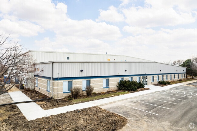
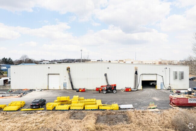
Property Detail
6950 Gisholt Dr
Madison, WI
LOT 2 CSM 6574 CS32/158&159-10/30/91 F/K/A ROYAL ADDN TO SOUTH TOWNE PLAT LOT 20 & F/K/A LOT 1 CSM 4319 CS18/225&226-3/29/84 F/K/A ROYAL ADDN TO SOUTH TOWNE PLA T LOT 21 DESCR AS SEC 30-7-10 SE1/4NE1/4 & NE1/4SE1/4 CONT 68,000 SQ FT
0710-301-6332-8
Dane
Commercialnec
Wisconsin
AE The base floodplain where base flood elevations are provided. AE Zones are now used on new format FIRMs instead of A1-A30 Zones.
2,20
2025
1.56 AC
2025
Southeast Madison
001502
Milwaukee/Madison
NEARBY LISTINGS FOR SALE OR LEASE
DEMOGRAPHICS near 6950 Gisholt Dr
1 mile
3 mile
5 mile
2025 Total Population
3,986
42,164
213,863
2030 Population
4,174
43,959
227,780
Pop Growth 2025-2030
+ 4.72%
+ 4.26%
+ 6.51%
Average Age
38
39
36
2025 Total Households
1,805
20,288
95,136
HH Growth 2025-2030
+ 5.15%
+ 4.58%
+ 6.88%
Median Household Inc
$69,032
$71,822
$68,825
Avg Household Size
2.20
2.00
2.10
2025 Avg HH Vehicles
2.00
2.00
1.00
Median Home Value
$293,181
$365,464
$380,548
Median Year Built
1972
1972
1982
Nearby Places
Map Layers
Map Styles
 Street
 Aerial
Layers
 Traffic
 Biking
Places
Listings with unknown addresses are not visible on the map
- Restaurants
- Banks
- Shops
- Fitness
- Groceries
PUBLIC TRANSPORTATION
AIRPORT
Dane County Regional/Truax Field
Drive
Walk
Distance
Dane County Regional/Truax Field
19 min
11.2 mi
Freight Ports
Port Milwaukee
Drive
Walk
Distance
Port Milwaukee
97 min
81.8 mi
SALE & LEASE HISTORY
LISTING DATE
SALE/LEASE

Nov 12, 2020
For Lease
Nearby Properties
Address
Land Use
TOTAL SIZE
Lot Size
Zoning
Address
Land Use
TOTAL SIZE
Lot Size
Zoning
177,906 SF
5.49 AC
CC-T
Address
Land Use
TOTAL SIZE
Lot Size
Zoning
188,206 SF
0.80 AC
UMX
Address
Land Use
TOTAL SIZE
Lot Size
Zoning
158,832 SF
0.58 AC
WP-17
Address
Land Use
TOTAL SIZE
Lot Size
Zoning
403,079 SF
1.08 AC
WP-17
Address
Land Use
TOTAL SIZE
Lot Size
Zoning
412,945 SF
1.30 AC
WP-17
Address
Land Use
TOTAL SIZE
Lot Size
Zoning
174,113 SF
2.71 AC
PD
Address
Land Use
TOTAL SIZE
Lot Size
Zoning
202,376 SF
1.59 AC
PD
Address
Land Use
TOTAL SIZE
Lot Size
Zoning
230,007 SF
0.76 AC
PD
Address
Land Use
TOTAL SIZE
Lot Size
Zoning
168,685 SF
14.05 AC
IL
Address
Land Use
TOTAL SIZE
Lot Size
Zoning
2.97 AC
Address
Land Use
TOTAL SIZE
Lot Size
Zoning
425,812 SF
1 AC
WP-17
Address
Land Use
TOTAL SIZE
Lot Size
Zoning
13.40 AC
Address
Land Use
TOTAL SIZE
Lot Size
Zoning
137,835 SF
1.49 AC
WP-17
Address
Land Use
TOTAL SIZE
Lot Size
Zoning
169,491 SF
0.79 AC
PD
Address
Land Use
TOTAL SIZE
Lot Size
Zoning
2.03 AC
Address
Land Use
TOTAL SIZE
Lot Size
Zoning
169,326 SF
0.37 AC
WP-17
Address
Land Use
TOTAL SIZE
Lot Size
Zoning
3.59 AC
Address
Land Use
TOTAL SIZE
Lot Size
Zoning
128,676 SF
1.66 AC
PD
Address
Land Use
TOTAL SIZE
Lot Size
Zoning
156,054 SF
9.40 AC
SE
Address
Land Use
TOTAL SIZE
Lot Size
Zoning
2.38 AC
Address
Land Use
TOTAL SIZE
Lot Size
Zoning
117,253 SF
0.81 AC
PD
Address
Land Use
TOTAL SIZE
Lot Size
Zoning
172,052 SF
4.09 AC
SE
Address
Land Use
TOTAL SIZE
Lot Size
Zoning
Address
Land Use
TOTAL SIZE
Lot Size
Zoning
124,648 SF
0.37 AC
PD
Address
Land Use
TOTAL SIZE
Lot Size
Zoning
21.92 AC
Address
Land Use
TOTAL SIZE
Lot Size
Zoning
93,386 SF
1 AC
PD
Address
Land Use
TOTAL SIZE
Lot Size
Zoning
78,416 SF
2.63 AC
PD
Address
Land Use
TOTAL SIZE
Lot Size
Zoning
5.53 AC
Address
Land Use
TOTAL SIZE
Lot Size
Zoning
202,374 SF
1.20 AC
DC
Address
Land Use
TOTAL SIZE
Lot Size
Zoning
4.56 AC
B-1
The World's #1 Commercial Real Estate Marketplace
Connect with us
© 2026 CoStar Group
The information above has been obtained from sources believed reliable. While we do not doubt its accuracy we have not verified it and make no guarantee, warranty or representation about it. It is your responsibility to independently confirm its accuracy and completeness. Any projections, opinions, assumptions, or estimates used are for example only and do not represent the current or future performance of the property. The value of this transaction to you depends on tax and other factors which should be evaluated by your tax, financial, and legal advisors. You and your advisors should conduct a careful, independent investigation of the property to determine to your satisfaction the suitability of the property for your needs.