Property Record
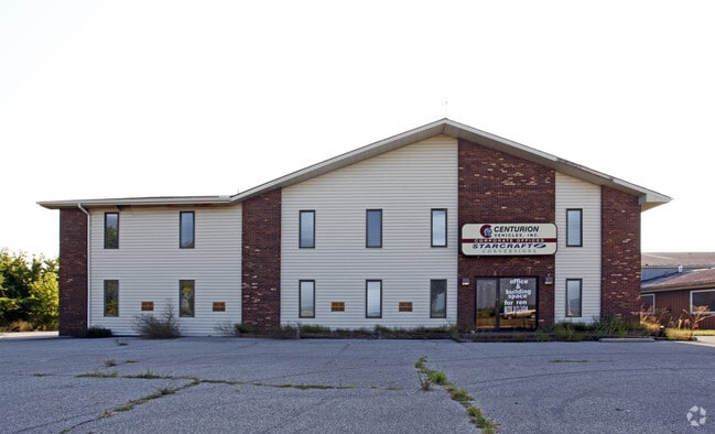
69651 Us Highway 131, White Pigeon, MI 49099

NEARBY LISTINGS FOR SALE OR LEASE
Property Detail
69651 Us Highway 131
016-012-062-00
Lopahs Subdivision
Industrialgeneral
COM AT INT OF W LN SEC 12 T8S R12W & NLY LN NYC RR R/W TH N ALG SEC LN 761 FT TO FENCE TH E ALG FENCE TO RR R/W TH SWLY ALG R
X
St. Joseph
18087C0025C
Michigan
2025
5.90 AC
2025
Michigan Southwest Area
041400
Other Market Areas
47,468 SF
Sturgis, MI
DEMOGRAPHICS near 69651 Us Highway 131
1 Mile
3 Mile
5 Mile
2024 Total Population
189
3,742
10,905
2029 Population
187
3,745
10,903
Pop Growth 2024-2029
(1.06%)
+ 0.08%
(0.02%)
Average Age
38
39
39
2024 Total Households
73
1,425
4,024
HH Growth 2024-2029
(1.37%)
0.00%
(0.20%)
Median Household Inc
$47,500
$57,472
$65,434
Avg Household Size
2.60
2.60
2.70
2024 Avg HH Vehicles
2.00
2.00
2.00
Median Home Value
$132,353
$160,591
$166,093
Median Year Built
1967
1972
1975
Nearby Places
Map Layers
Map Styles
 Street
 Aerial
- Restaurants
- Banks
- Shops
- Fitness
- Groceries
PUBLIC TRANSPORTATION
AIRPORT
Kalamazoo/Battle Creek International
DRIVE
WALK
Distance
Kalamazoo/Battle Creek International
50 min
37.8 mi
South Bend International
DRIVE
WALK
Distance
South Bend International
58 min
42.9 mi
SALE & LEASE HISTORY
LISTING DATE
SALE/LEASE

Dec 08, 2021
For Sale
Nearby Properties
Address
Land Use
TOTAL SIZE
Lot Size
Zoning
Address
Land Use
TOTAL SIZE
Lot Size
Zoning
416,870 SF
51.28 AC
ZO01
Address
Land Use
TOTAL SIZE
Lot Size
Zoning
459,670 SF
51.93 AC
ZO01
Address
Land Use
TOTAL SIZE
Lot Size
Zoning
580,975 SF
61.76 AC
ZO01
Address
Land Use
TOTAL SIZE
Lot Size
Zoning
182,958 SF
31.70 AC
ZO01
Address
Land Use
TOTAL SIZE
Lot Size
Zoning
169,230 SF
22.92 AC
Address
Land Use
TOTAL SIZE
Lot Size
Zoning
570,858 SF
74.05 AC
Address
Land Use
TOTAL SIZE
Lot Size
Zoning
192,080 SF
28.69 AC
ZO01
Address
Land Use
TOTAL SIZE
Lot Size
Zoning
198,158 SF
19.23 AC
ZO01
Address
Land Use
TOTAL SIZE
Lot Size
Zoning
178,100 SF
40 AC
ZO01
Address
Land Use
TOTAL SIZE
Lot Size
Zoning
397,711 SF
47.47 AC
Address
Land Use
TOTAL SIZE
Lot Size
Zoning
139,474 SF
20.08 AC
ZO01
Address
Land Use
TOTAL SIZE
Lot Size
Zoning
108,328 SF
8.52 AC
ZO01
Address
Land Use
TOTAL SIZE
Lot Size
Zoning
158,100 SF
55.99 AC
Address
Land Use
TOTAL SIZE
Lot Size
Zoning
1,536 SF
82.22 AC
Address
Land Use
TOTAL SIZE
Lot Size
Zoning
141,408 SF
26.71 AC
ZO01
Address
Land Use
TOTAL SIZE
Lot Size
Zoning
99,068 SF
12.58 AC
ZO01
Address
Land Use
TOTAL SIZE
Lot Size
Zoning
207,015 SF
28.49 AC
Address
Land Use
TOTAL SIZE
Lot Size
Zoning
16,250 SF
5.01 AC
ZO01
Address
Land Use
TOTAL SIZE
Lot Size
Zoning
37,200 SF
5 AC
ZO01
Address
Land Use
TOTAL SIZE
Lot Size
Zoning
93,527 SF
47 AC
Address
Land Use
TOTAL SIZE
Lot Size
Zoning
77,061 SF
15 AC
Address
Land Use
TOTAL SIZE
Lot Size
Zoning
1,260 SF
332.03 AC
Address
Land Use
TOTAL SIZE
Lot Size
Zoning
2,998 SF
286.66 AC
Address
Land Use
TOTAL SIZE
Lot Size
Zoning
206,202 SF
18.28 AC
Address
Land Use
TOTAL SIZE
Lot Size
Zoning
243.80 AC
Address
Land Use
TOTAL SIZE
Lot Size
Zoning
113,876 SF
5.20 AC
Address
Land Use
TOTAL SIZE
Lot Size
Zoning
47,293 SF
14.98 AC
Address
Land Use
TOTAL SIZE
Lot Size
Zoning
3,200 SF
1.59 AC
Address
Land Use
TOTAL SIZE
Lot Size
Zoning
106.20 AC
Address
Land Use
TOTAL SIZE
Lot Size
Zoning
220.54 AC
The World's #1 Commercial Real Estate Marketplace
Connect with us
© 2026 CoStar Group
The information above has been obtained from sources believed reliable. While we do not doubt its accuracy we have not verified it and make no guarantee, warranty or representation about it. It is your responsibility to independently confirm its accuracy and completeness. Any projections, opinions, assumptions, or estimates used are for example only and do not represent the current or future performance of the property. The value of this transaction to you depends on tax and other factors which should be evaluated by your tax, financial, and legal advisors. You and your advisors should conduct a careful, independent investigation of the property to determine to your satisfaction the suitability of the property for your needs.