Property Record
6968 Howell Sugar Land Rd, Houston, TX 77083


NEARBY LISTINGS FOR SALE OR LEASE
Property Detail
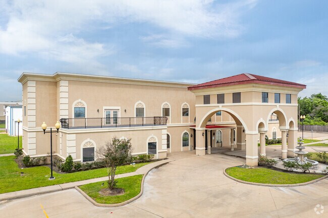
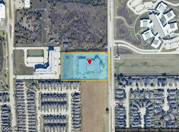
6968 Howell Sugar Land Rd
1300070010001
Houston Event Planning
Outdoorrecreationbeachmountaindesert
RES A BLK 1 HOUSTON EVENT PLANNING
X
Harris
48157C0135L
Texas
2024
4 AC
2025
Southwest Beltway 8
452703
Houston
35,094 SF
Houston-The Woodlands-Sugar Land, TX
DEMOGRAPHICS near 6968 Howell Sugar Land Rd
1 Mile
3 Mile
5 Mile
2024 Total Population
19,550
177,359
411,568
2029 Population
19,712
188,036
441,484
Pop Growth 2024-2029
+ 0.83%
+ 6.02%
+ 7.27%
Average Age
37
37
37
2024 Total Households
6,190
57,863
143,383
HH Growth 2024-2029
+ 0.69%
+ 5.72%
+ 6.77%
Median Household Inc
$46,358
$54,114
$58,172
Avg Household Size
3.00
3.00
2.80
2024 Avg HH Vehicles
2.00
2.00
2.00
Median Home Value
$216,509
$186,695
$225,989
Median Year Built
1989
1987
1987
Nearby Places
Map Layers
Map Styles
 Street
 Aerial
- Restaurants
- Banks
- Shops
- Fitness
- Groceries
PUBLIC TRANSPORTATION
AIRPORT
William P Hobby
DRIVE
WALK
Distance
William P Hobby
44 min
28.7 mi
George Bush Intcntl/Houston
DRIVE
WALK
Distance
George Bush Intcntl/Houston
46 min
37.2 mi
Freight Ports
Port of Houston
DRIVE
WALK
Distance
Port of Houston
41 min
28.1 mi
SALE & LEASE HISTORY
LISTING DATE
SALE/LEASE

Jan 29, 2023
For Sale
Nearby Properties
Address
Land Use
TOTAL SIZE
Lot Size
Zoning
Address
Land Use
TOTAL SIZE
Lot Size
Zoning
1,376,776 SF
113.43 AC
Address
Land Use
TOTAL SIZE
Lot Size
Zoning
403,080 SF
19.17 AC
Address
Land Use
TOTAL SIZE
Lot Size
Zoning
94,547 SF
13.59 AC
Address
Land Use
TOTAL SIZE
Lot Size
Zoning
489,192 SF
23.11 AC
Address
Land Use
TOTAL SIZE
Lot Size
Zoning
126,308 SF
16.95 AC
Address
Land Use
TOTAL SIZE
Lot Size
Zoning
288,868 SF
9.37 AC
Address
Land Use
TOTAL SIZE
Lot Size
Zoning
526,945 SF
23.05 AC
Address
Land Use
TOTAL SIZE
Lot Size
Zoning
690,119 SF
23 AC
Address
Land Use
TOTAL SIZE
Lot Size
Zoning
425,887 SF
26.70 AC
Address
Land Use
TOTAL SIZE
Lot Size
Zoning
364,571 SF
19.23 AC
Address
Land Use
TOTAL SIZE
Lot Size
Zoning
425,069 SF
25.14 AC
Address
Land Use
TOTAL SIZE
Lot Size
Zoning
286,285 SF
11.78 AC
Address
Land Use
TOTAL SIZE
Lot Size
Zoning
419,988 SF
13.09 AC
Address
Land Use
TOTAL SIZE
Lot Size
Zoning
443,209 SF
25.13 AC
Address
Land Use
TOTAL SIZE
Lot Size
Zoning
297,095 SF
Address
Land Use
TOTAL SIZE
Lot Size
Zoning
332,872 SF
13 AC
Address
Land Use
TOTAL SIZE
Lot Size
Zoning
305,370 SF
11.49 AC
Address
Land Use
TOTAL SIZE
Lot Size
Zoning
300,014 SF
14.13 AC
Address
Land Use
TOTAL SIZE
Lot Size
Zoning
396,100 SF
18.02 AC
Address
Land Use
TOTAL SIZE
Lot Size
Zoning
459,199 SF
15.74 AC
Address
Land Use
TOTAL SIZE
Lot Size
Zoning
229,486 SF
7.14 AC
Address
Land Use
TOTAL SIZE
Lot Size
Zoning
351,177 SF
15.81 AC
Address
Land Use
TOTAL SIZE
Lot Size
Zoning
274,158 SF
10.51 AC
Address
Land Use
TOTAL SIZE
Lot Size
Zoning
234,634 SF
11.07 AC
Address
Land Use
TOTAL SIZE
Lot Size
Zoning
205,950 SF
8.50 AC
Address
Land Use
TOTAL SIZE
Lot Size
Zoning
158,975 SF
46.38 AC
YQ
Address
Land Use
TOTAL SIZE
Lot Size
Zoning
206,121 SF
23.28 AC
Address
Land Use
TOTAL SIZE
Lot Size
Zoning
384,284 SF
18.32 AC
Address
Land Use
TOTAL SIZE
Lot Size
Zoning
268,534 SF
22.81 AC
Address
Land Use
TOTAL SIZE
Lot Size
Zoning
311,010 SF
12.36 AC
The World's #1 Commercial Real Estate Marketplace
Connect with us
© 2025 CoStar Group
The information above has been obtained from sources believed reliable. While we do not doubt its accuracy we have not verified it and make no guarantee, warranty or representation about it. It is your responsibility to independently confirm its accuracy and completeness. Any projections, opinions, assumptions, or estimates used are for example only and do not represent the current or future performance of the property. The value of this transaction to you depends on tax and other factors which should be evaluated by your tax, financial, and legal advisors. You and your advisors should conduct a careful, independent investigation of the property to determine to your satisfaction the suitability of the property for your needs.