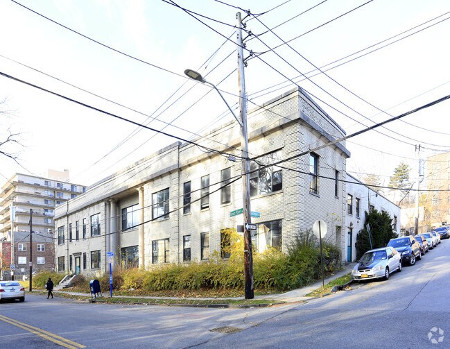
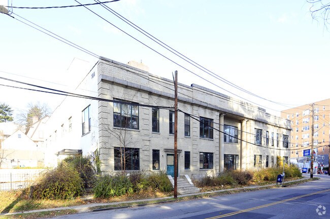
Property Record
697 Bronx River Rd, Yonkers, NY 10704
NEARBY LISTINGS FOR SALE OR LEASE
Property Detail
697 Bronx River Rd
1800-005-000-05227-000-0001
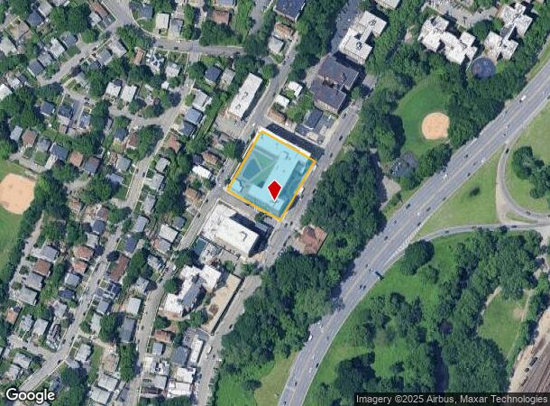
Map Of Lincoln Heights
Apartment
Westchester
X
New York
36119C0336F
1.000
2025
1.03 AC
2024
Southwest
002403
Westchester/So Connecticut
239,150 SF
New York-Jersey City-White Plains, NY-NJ
DEMOGRAPHICS near 697 Bronx River Rd
1 Mile
3 Mile
5 Mile
2024 Total Population
45,970
361,127
891,666
2029 Population
44,577
344,049
845,061
Pop Growth 2024-2029
(3.03%)
(4.73%)
(5.23%)
Average Age
42
40
40
2024 Total Households
19,193
132,627
331,445
HH Growth 2024-2029
(3.00%)
(4.90%)
(5.56%)
Median Household Inc
$83,277
$71,757
$67,734
Avg Household Size
2.30
2.60
2.50
2024 Avg HH Vehicles
1.00
1.00
1.00
Median Home Value
$397,000
$537,977
$543,921
Median Year Built
1950
1950
1952
Nearby Places
- Restaurants
- Banks
- Shops
- Fitness
- Groceries
PUBLIC TRANSPORTATION
COMMUTER RAIL
Fleetwood Station (Harlem Line - Metro-North Commuter Railroad Company (Metro-North))
DRIVE
WALK
Distance
Fleetwood Station (Harlem Line - Metro-North Commuter Railroad Company (Metro-North))
2 min
12 min
0.6 mi
Mount Vernon West Station (Harlem Line - Metro-North Commuter Railroad Company (Metro-North))
DRIVE
WALK
Distance
Mount Vernon West Station (Harlem Line - Metro-North Commuter Railroad Company (Metro-North))
8 min
16 min
0.9 mi
AIRPORT
LaGuardia
DRIVE
WALK
Distance
LaGuardia
27 min
15.3 mi
Westchester County
DRIVE
WALK
Distance
Westchester County
26 min
17.1 mi
John F Kennedy International
DRIVE
WALK
Distance
John F Kennedy International
34 min
22.8 mi
Freight Ports
NY - Red Hook Container Terminal
DRIVE
WALK
Distance
NY - Red Hook Container Terminal
40 min
23.5 mi
Nearby Properties
Address
Land Use
TOTAL SIZE
Lot Size
Zoning
Address
Land Use
TOTAL SIZE
Lot Size
Zoning
18,000 SF
13.85 AC
A
Address
Land Use
TOTAL SIZE
Lot Size
Zoning
201,590 SF
4.13 AC
BA
Address
Land Use
TOTAL SIZE
Lot Size
Zoning
301,156 SF
13.94 AC
A
Address
Land Use
TOTAL SIZE
Lot Size
Zoning
70,737 SF
1.67 AC
BB
Address
Land Use
TOTAL SIZE
Lot Size
Zoning
4,000 SF
19.83 AC
BUS
Address
Land Use
TOTAL SIZE
Lot Size
Zoning
617,567 SF
3.19 AC
R7-1
Address
Land Use
TOTAL SIZE
Lot Size
Zoning
Address
Land Use
TOTAL SIZE
Lot Size
Zoning
Address
Land Use
TOTAL SIZE
Lot Size
Zoning
269,100 SF
1.63 AC
R4
Address
Land Use
TOTAL SIZE
Lot Size
Zoning
18,445 SF
510.83 AC
PARK
Address
Land Use
TOTAL SIZE
Lot Size
Zoning
64,165 SF
3.24 AC
B
Address
Land Use
TOTAL SIZE
Lot Size
Zoning
165,529 SF
7.05 AC
RA3
Address
Land Use
TOTAL SIZE
Lot Size
Zoning
1,028,976 SF
23.03 AC
R5
Address
Land Use
TOTAL SIZE
Lot Size
Zoning
1,038,034 SF
23.41 AC
R5
Address
Land Use
TOTAL SIZE
Lot Size
Zoning
61,055 SF
343.42 AC
R6
Address
Land Use
TOTAL SIZE
Lot Size
Zoning
5,170 SF
9.08 AC
B
Address
Land Use
TOTAL SIZE
Lot Size
Zoning
Address
Land Use
TOTAL SIZE
Lot Size
Zoning
306,540 SF
11.67 AC
R5
Address
Land Use
TOTAL SIZE
Lot Size
Zoning
560 SF
61.32 AC
PARK
Address
Land Use
TOTAL SIZE
Lot Size
Zoning
336,240 SF
8.45 AC
R5
Address
Land Use
TOTAL SIZE
Lot Size
Zoning
125,143 SF
2.21 AC
R4
Address
Land Use
TOTAL SIZE
Lot Size
Zoning
219,285 SF
15.51 AC
R4
Address
Land Use
TOTAL SIZE
Lot Size
Zoning
181,092 SF
3.47 AC
R4
Address
Land Use
TOTAL SIZE
Lot Size
Zoning
103,158 SF
1.82 AC
R4
Address
Land Use
TOTAL SIZE
Lot Size
Zoning
Address
Land Use
TOTAL SIZE
Lot Size
Zoning
38,912 SF
19.25 AC
R4
Address
Land Use
TOTAL SIZE
Lot Size
Zoning
7,855 SF
1.10 AC
C
Address
Land Use
TOTAL SIZE
Lot Size
Zoning
143,260 SF
1.79 AC
R5
Address
Land Use
TOTAL SIZE
Lot Size
Zoning
13,225 SF
136.69 AC
PARK
Address
Land Use
TOTAL SIZE
Lot Size
Zoning
35,325 SF
4.66 AC
R5
The World's #1 Commercial Real Estate Marketplace
Connect with us
© 2025 CoStar Group
The information above has been obtained from sources believed reliable. While we do not doubt its accuracy we have not verified it and make no guarantee, warranty or representation about it. It is your responsibility to independently confirm its accuracy and completeness. Any projections, opinions, assumptions, or estimates used are for example only and do not represent the current or future performance of the property. The value of this transaction to you depends on tax and other factors which should be evaluated by your tax, financial, and legal advisors. You and your advisors should conduct a careful, independent investigation of the property to determine to your satisfaction the suitability of the property for your needs.