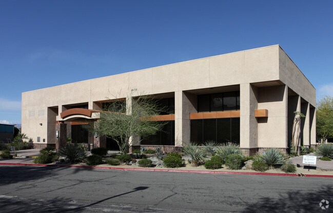
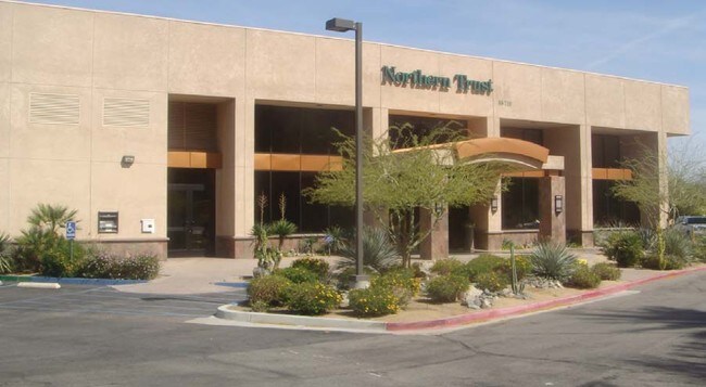
Property Record
69730 Highway 111, Rancho Mirage, CA 92270


NEARBY LISTINGS FOR SALE OR LEASE
Property Detail
69730 Highway 111
674-490-043
2.93 ACRES IN PAR 3 PM 232/076
Officebuilding
Riverside
X
California
06065C1589G
3
2024
2.93 AC
2025
Coachella Valley
940900
Inland Empire (California)
48,611 SF
Riverside-San Bernardino-Ontario, CA
DEMOGRAPHICS near 69730 Highway 111
1 Mile
3 Mile
5 Mile
2024 Total Population
6,359
47,917
125,389
2029 Population
6,993
52,703
137,297
Pop Growth 2024-2029
+ 9.97%
+ 9.99%
+ 9.50%
Average Age
57
52
50
2024 Total Households
3,228
22,539
55,227
HH Growth 2024-2029
+ 9.63%
+ 10.27%
+ 9.95%
Median Household Inc
$70,037
$66,692
$69,679
Avg Household Size
1.90
2.10
2.20
2024 Avg HH Vehicles
2.00
2.00
2.00
Median Home Value
$500,499
$613,823
$547,009
Median Year Built
1982
1984
1985
Nearby Places
Map Layers
Map Styles
 Street
 Aerial
- Restaurants
- Banks
- Shops
- Fitness
- Groceries
PUBLIC TRANSPORTATION
AIRPORT
Palm Springs International
DRIVE
WALK
Distance
Palm Springs International
12 min
6.6 mi
Freight Ports
Port of San Diego
DRIVE
WALK
Distance
Port of San Diego
165 min
134.4 mi
Nearby Properties
Address
Land Use
TOTAL SIZE
Lot Size
Zoning
Address
Land Use
TOTAL SIZE
Lot Size
Zoning
370,095 SF
53.22 AC
Address
Land Use
TOTAL SIZE
Lot Size
Zoning
68.20 AC
Address
Land Use
TOTAL SIZE
Lot Size
Zoning
91,939 SF
8.80 AC
Address
Land Use
TOTAL SIZE
Lot Size
Zoning
186,531 SF
6 AC
Address
Land Use
TOTAL SIZE
Lot Size
Zoning
103,940 SF
4.56 AC
Address
Land Use
TOTAL SIZE
Lot Size
Zoning
Address
Land Use
TOTAL SIZE
Lot Size
Zoning
208,000 SF
16.04 AC
Address
Land Use
TOTAL SIZE
Lot Size
Zoning
322,000 SF
19.09 AC
Address
Land Use
TOTAL SIZE
Lot Size
Zoning
141,574 SF
44.60 AC
Address
Land Use
TOTAL SIZE
Lot Size
Zoning
Address
Land Use
TOTAL SIZE
Lot Size
Zoning
41,962 SF
5 AC
Address
Land Use
TOTAL SIZE
Lot Size
Zoning
38,388 SF
8.31 AC
R3
Address
Land Use
TOTAL SIZE
Lot Size
Zoning
36,514 SF
2.10 AC
PUDA
Address
Land Use
TOTAL SIZE
Lot Size
Zoning
92,722 SF
5.55 AC
O
Address
Land Use
TOTAL SIZE
Lot Size
Zoning
32,158 SF
1.96 AC
PUDLC
Address
Land Use
TOTAL SIZE
Lot Size
Zoning
66,732 SF
1.80 AC
PCC
Address
Land Use
TOTAL SIZE
Lot Size
Zoning
71,665 SF
3.31 AC
CN
Address
Land Use
TOTAL SIZE
Lot Size
Zoning
6,717 SF
17.79 AC
Address
Land Use
TOTAL SIZE
Lot Size
Zoning
73,256 SF
21.69 AC
R2-B
Address
Land Use
TOTAL SIZE
Lot Size
Zoning
144,780 SF
15.36 AC
Address
Land Use
TOTAL SIZE
Lot Size
Zoning
32,333 SF
2.80 AC
C-N
Address
Land Use
TOTAL SIZE
Lot Size
Zoning
3,520 SF
2.63 AC
Address
Land Use
TOTAL SIZE
Lot Size
Zoning
102,304 SF
8.98 AC
CPS
Address
Land Use
TOTAL SIZE
Lot Size
Zoning
4,026 SF
9.49 AC
R204M
Address
Land Use
TOTAL SIZE
Lot Size
Zoning
46,528 SF
1.89 AC
CPS
Address
Land Use
TOTAL SIZE
Lot Size
Zoning
22,594 SF
1.37 AC
POC3
Address
Land Use
TOTAL SIZE
Lot Size
Zoning
Address
Land Use
TOTAL SIZE
Lot Size
Zoning
30,286 SF
18.84 AC
Address
Land Use
TOTAL SIZE
Lot Size
Zoning
43,336 SF
6.79 AC
PUDA
The World's #1 Commercial Real Estate Marketplace
Connect with us
© 2025 CoStar Group
The information above has been obtained from sources believed reliable. While we do not doubt its accuracy we have not verified it and make no guarantee, warranty or representation about it. It is your responsibility to independently confirm its accuracy and completeness. Any projections, opinions, assumptions, or estimates used are for example only and do not represent the current or future performance of the property. The value of this transaction to you depends on tax and other factors which should be evaluated by your tax, financial, and legal advisors. You and your advisors should conduct a careful, independent investigation of the property to determine to your satisfaction the suitability of the property for your needs.