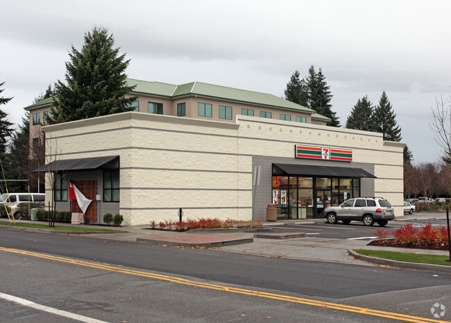
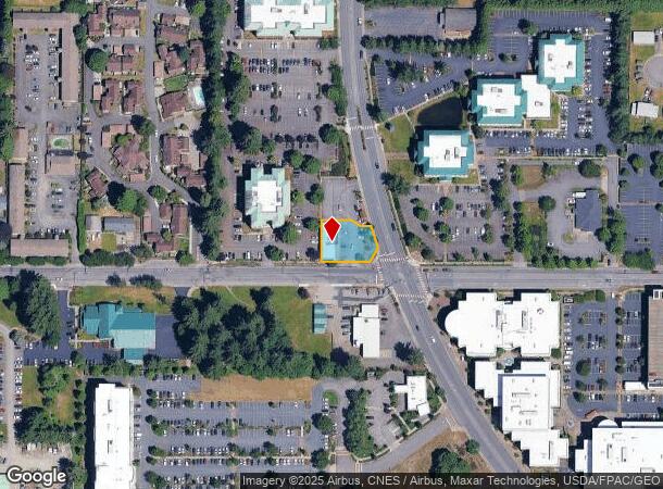
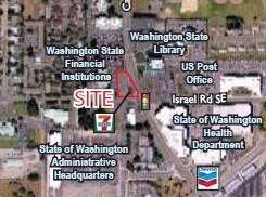
Property Record
6975 Capitol Blvd Sw, Tumwater, WA 98501
NEARBY LISTINGS FOR SALE OR LEASE
Property Detail
6975 Capitol Blvd Sw
Olympia-Tumwater, WA
Brighton Park;
37000000908
SECTION 03 / 02 TOWNSHIP 17 / 17 RANGE 2W / 2W QUARTER NE SE / NW SW PLAT BRIGHTON PARK; SS110902TW LT 1 DOCUMENT 4241067
Supermarket
Thurston
X
Washington
53067C0281F
1
2024
0.27 AC
2024
Tumwater/S Olympia
010801
Olympia
3,060 SF
DEMOGRAPHICS near 6975 Capitol Blvd Sw
1 Mile
3 Mile
5 Mile
2024 Total Population
5,092
42,446
117,308
2029 Population
5,432
45,097
123,995
Pop Growth 2024-2029
+ 6.68%
+ 6.25%
+ 5.70%
Average Age
40
41
41
2024 Total Households
2,326
17,302
49,209
HH Growth 2024-2029
+ 6.62%
+ 6.27%
+ 5.83%
Median Household Inc
$62,217
$83,792
$73,791
Avg Household Size
2.20
2.40
2.30
2024 Avg HH Vehicles
2.00
2.00
2.00
Median Home Value
$320,790
$421,496
$408,869
Median Year Built
1977
1991
1989
Nearby Places
Map Layers
Map Styles
 Street
 Aerial
- Restaurants
- Banks
- Shops
- Fitness
- Groceries
Nearby Properties
Address
Land Use
TOTAL SIZE
Lot Size
Zoning
Address
Land Use
TOTAL SIZE
Lot Size
Zoning
523,407 SF
86.49 AC
R-4-8
Address
Land Use
TOTAL SIZE
Lot Size
Zoning
1,099,200 SF
79.09 AC
LI
Address
Land Use
TOTAL SIZE
Lot Size
Zoning
395,355 SF
35.74 AC
TC
Address
Land Use
TOTAL SIZE
Lot Size
Zoning
353,503 SF
36.94 AC
MFM
Address
Land Use
TOTAL SIZE
Lot Size
Zoning
184,887 SF
41 AC
SFM1
Address
Land Use
TOTAL SIZE
Lot Size
Zoning
235,042 SF
17.16 AC
MFM
Address
Land Use
TOTAL SIZE
Lot Size
Zoning
226,221 SF
Address
Land Use
TOTAL SIZE
Lot Size
Zoning
146,122 SF
Address
Land Use
TOTAL SIZE
Lot Size
Zoning
163,487 SF
34.49 AC
CS
Address
Land Use
TOTAL SIZE
Lot Size
Zoning
102,698 SF
14.81 AC
LI
Address
Land Use
TOTAL SIZE
Lot Size
Zoning
197,571 SF
52.35 AC
R-4-8
Address
Land Use
TOTAL SIZE
Lot Size
Zoning
199,920 SF
14.38 AC
Address
Land Use
TOTAL SIZE
Lot Size
Zoning
199,880 SF
14.54 AC
Address
Land Use
TOTAL SIZE
Lot Size
Zoning
147,418 SF
11.74 AC
MFH
Address
Land Use
TOTAL SIZE
Lot Size
Zoning
175,938 SF
13 AC
MFM
Address
Land Use
TOTAL SIZE
Lot Size
Zoning
120,284 SF
118 AC
ARI2
Address
Land Use
TOTAL SIZE
Lot Size
Zoning
155,386 SF
6.88 AC
CBC
Address
Land Use
TOTAL SIZE
Lot Size
Zoning
80,956 SF
20.97 AC
SFL
Address
Land Use
TOTAL SIZE
Lot Size
Zoning
140,850 SF
5.73 AC
MFH
Address
Land Use
TOTAL SIZE
Lot Size
Zoning
151,654 SF
6.75 AC
CBC
Address
Land Use
TOTAL SIZE
Lot Size
Zoning
157,625 SF
1.46 AC
TC2
Address
Land Use
TOTAL SIZE
Lot Size
Zoning
110,064 SF
3.47 AC
UV
Address
Land Use
TOTAL SIZE
Lot Size
Zoning
78,580 SF
21.38 AC
ARI
Address
Land Use
TOTAL SIZE
Lot Size
Zoning
105,464 SF
3.06 AC
UV
Address
Land Use
TOTAL SIZE
Lot Size
Zoning
112,020 SF
5.91 AC
MFH
Address
Land Use
TOTAL SIZE
Lot Size
Zoning
131,905 SF
1.30 AC
TC
Address
Land Use
TOTAL SIZE
Lot Size
Zoning
149,802 SF
Address
Land Use
TOTAL SIZE
Lot Size
Zoning
248,879 SF
11.16 AC
LI
Address
Land Use
TOTAL SIZE
Lot Size
Zoning
99,736 SF
6.76 AC
GC
Address
Land Use
TOTAL SIZE
Lot Size
Zoning
76,142 SF
11.94 AC
TC
The World's #1 Commercial Real Estate Marketplace
Connect with us
© 2025 CoStar Group
The information above has been obtained from sources believed reliable. While we do not doubt its accuracy we have not verified it and make no guarantee, warranty or representation about it. It is your responsibility to independently confirm its accuracy and completeness. Any projections, opinions, assumptions, or estimates used are for example only and do not represent the current or future performance of the property. The value of this transaction to you depends on tax and other factors which should be evaluated by your tax, financial, and legal advisors. You and your advisors should conduct a careful, independent investigation of the property to determine to your satisfaction the suitability of the property for your needs.