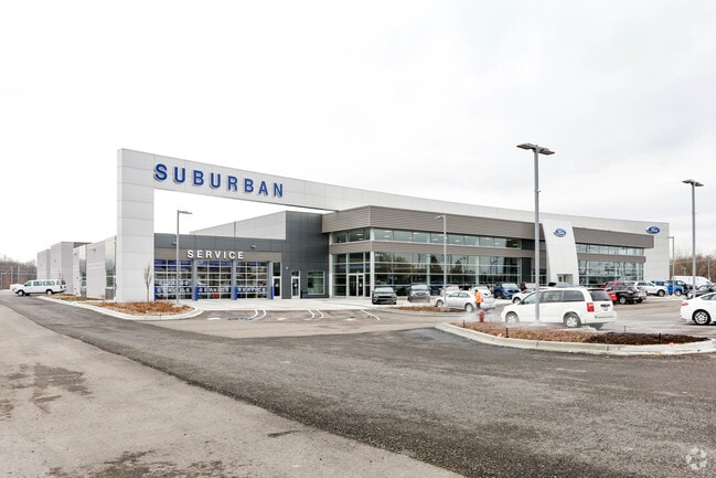
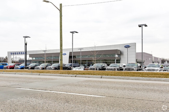
Property Record
6975 Highland Rd, Waterford, MI 48327

NEARBY LISTINGS FOR SALE OR LEASE
Property Detail
6975 Highland Rd
Detroit-Warren-Dearborn, MI
Supervisors Plat No 3
13-20-101-090
T3N, R9E, SEC 20 SUPERVISOR'S PLAT NO 31 LOTS 4 TO 19 INCL 11-27-17 FR 001 TO 015 INCL
Vehiclerentalsvehiclesales
Oakland
X
Michigan
26125C0341F
4-19
2024
19.27 AC
2025
Lakes Area
145600
Detroit
86,192 SF
DEMOGRAPHICS near 6975 Highland Rd
1 Mile
3 Mile
5 Mile
2024 Total Population
4,359
45,907
115,981
2029 Population
4,314
45,479
114,908
Pop Growth 2024-2029
(1.03%)
(0.93%)
(0.93%)
Average Age
42
43
43
2024 Total Households
1,901
19,698
48,894
HH Growth 2024-2029
(1.05%)
(0.98%)
(0.95%)
Median Household Inc
$70,986
$75,206
$78,796
Avg Household Size
2.20
2.30
2.30
2024 Avg HH Vehicles
2.00
2.00
2.00
Median Home Value
$235,572
$239,068
$258,257
Median Year Built
1987
1975
1973
Nearby Places
Map Layers
Map Styles
 Street
 Aerial
- Restaurants
- Banks
- Shops
- Fitness
- Groceries
PUBLIC TRANSPORTATION
COMMUTER RAIL
DRIVE
WALK
Distance
14 min
7.6 mi
AIRPORT
Bishop International
DRIVE
WALK
Distance
Bishop International
52 min
33.1 mi
Detroit Metro Wayne County
DRIVE
WALK
Distance
Detroit Metro Wayne County
57 min
40.4 mi
Windsor International
DRIVE
WALK
Distance
Windsor International
71 min
46.7 mi
Nearby Properties
Address
Land Use
TOTAL SIZE
Lot Size
Zoning
Address
Land Use
TOTAL SIZE
Lot Size
Zoning
232,743 SF
40 AC
BI
Address
Land Use
TOTAL SIZE
Lot Size
Zoning
1,075,040 SF
90.26 AC
II
Address
Land Use
TOTAL SIZE
Lot Size
Zoning
300,934 SF
25.30 AC
AI
Address
Land Use
TOTAL SIZE
Lot Size
Zoning
178,417 SF
39.45 AC
Address
Land Use
TOTAL SIZE
Lot Size
Zoning
240,398 SF
23.50 AC
AI
Address
Land Use
TOTAL SIZE
Lot Size
Zoning
190,753 SF
16.54 AC
AI
Address
Land Use
TOTAL SIZE
Lot Size
Zoning
16,640 SF
13.07 AC
ME
Address
Land Use
TOTAL SIZE
Lot Size
Zoning
219,124 SF
18.63 AC
AI
Address
Land Use
TOTAL SIZE
Lot Size
Zoning
415,169 SF
27.93 AC
II
Address
Land Use
TOTAL SIZE
Lot Size
Zoning
150,669 SF
16.57 AC
AI
Address
Land Use
TOTAL SIZE
Lot Size
Zoning
147,624 SF
6.59 AC
AI
Address
Land Use
TOTAL SIZE
Lot Size
Zoning
4,011 SF
53.71 AC
MM
Address
Land Use
TOTAL SIZE
Lot Size
Zoning
151,611 SF
12.16 AC
AI
Address
Land Use
TOTAL SIZE
Lot Size
Zoning
126,844 SF
3.20 AC
ME
Address
Land Use
TOTAL SIZE
Lot Size
Zoning
3,908 SF
54.90 AC
MM
Address
Land Use
TOTAL SIZE
Lot Size
Zoning
235,395 SF
Address
Land Use
TOTAL SIZE
Lot Size
Zoning
93,541 SF
21.75 AC
SV
Address
Land Use
TOTAL SIZE
Lot Size
Zoning
235,395 SF
Address
Land Use
TOTAL SIZE
Lot Size
Zoning
205,961 SF
16.57 AC
II
Address
Land Use
TOTAL SIZE
Lot Size
Zoning
105,874 SF
13.07 AC
BI
Address
Land Use
TOTAL SIZE
Lot Size
Zoning
235,395 SF
37.19 AC
Address
Land Use
TOTAL SIZE
Lot Size
Zoning
235,395 SF
34.42 AC
Address
Land Use
TOTAL SIZE
Lot Size
Zoning
128,290 SF
9.26 AC
BI
Address
Land Use
TOTAL SIZE
Lot Size
Zoning
65,034 SF
10.28 AC
AI
Address
Land Use
TOTAL SIZE
Lot Size
Zoning
120,132 SF
9.29 AC
AI
Address
Land Use
TOTAL SIZE
Lot Size
Zoning
156,808 SF
13.11 AC
PB
Address
Land Use
TOTAL SIZE
Lot Size
Zoning
92,821 SF
12.19 AC
BI
Address
Land Use
TOTAL SIZE
Lot Size
Zoning
104,296 SF
11.10 AC
BI
Address
Land Use
TOTAL SIZE
Lot Size
Zoning
95,592 SF
12.43 AC
AI
The World's #1 Commercial Real Estate Marketplace
Connect with us
© 2025 CoStar Group
The information above has been obtained from sources believed reliable. While we do not doubt its accuracy we have not verified it and make no guarantee, warranty or representation about it. It is your responsibility to independently confirm its accuracy and completeness. Any projections, opinions, assumptions, or estimates used are for example only and do not represent the current or future performance of the property. The value of this transaction to you depends on tax and other factors which should be evaluated by your tax, financial, and legal advisors. You and your advisors should conduct a careful, independent investigation of the property to determine to your satisfaction the suitability of the property for your needs.