Property Record
6996 Highway 2, Commerce City, CO 80022

Property Detail
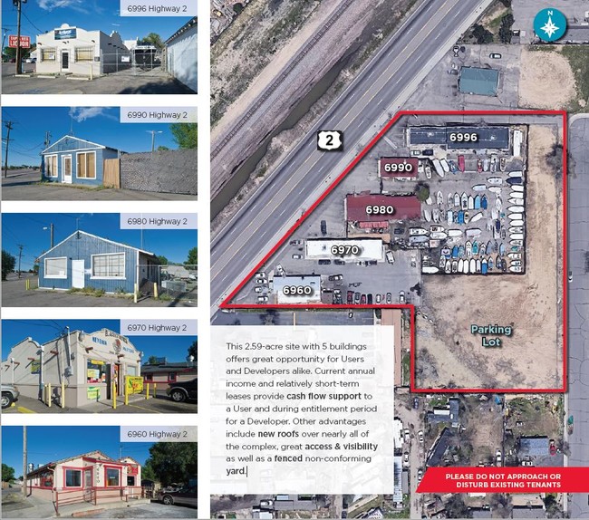
6996 Highway 2
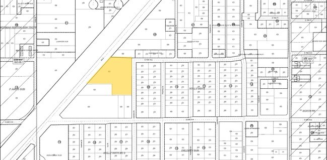
1823-05-2-00-001
SECT,TWN,RNG:5-3-67 DESC: BEG AT A PT ON THE SELY ROW LN S/H 2 WHICH IS 1050 FT N OF S LN SD SW4 NW4 TH NELY ALG SD SELY ROW LN S/H 2 336/6 FT TH E 243/2 FT TO A PT WHICH IS 1397/2 FT N OF S LN SD SW4 NW4 TH S 367/2 FT TO A PT WHICH IS 1646/5 FT W OF
Storebuilding
Adams
B and X Area of moderate flood hazard, usually the area between the limits of the 100-year and 500-year floods.
Colorado
2024
2.59 AC
2025
Northeast Denver
008705
Denver
9,880 SF
Denver-Aurora-Centennial, CO
NEARBY LISTINGS FOR SALE OR LEASE
DEMOGRAPHICS near 6996 Highway 2
1 mile
3 mile
5 mile
2024 Total Population
15,983
48,541
187,731
2029 Population
16,459
50,021
192,689
Pop Growth 2024-2029
+ 2.98%
+ 3.05%
+ 2.64%
Average Age
35
35
36
2024 Total Households
4,752
15,325
64,143
HH Growth 2024-2029
+ 2.95%
+ 3.03%
+ 2.57%
Median Household Inc
$53,188
$67,556
$74,361
Avg Household Size
3.20
3.10
2.80
2024 Avg HH Vehicles
2.00
2.00
2.00
Median Home Value
$301,955
$344,205
$396,920
Median Year Built
1958
1977
1976
Nearby Places
Map Layers
Map Styles
 Street
 Aerial
Transit
 Traffic
 Biking
Places
Listings with unknown addresses are not visible on the map
- Restaurants
- Banks
- Shops
- Fitness
- Groceries
PUBLIC TRANSPORTATION
COMMUTER RAIL
Drive
Walk
Distance
6 min
2.1 mi
Drive
Walk
Distance
7 min
4.1 mi
AIRPORT
Denver International
Drive
Walk
Distance
Denver International
28 min
18.7 mi
SALE & LEASE HISTORY
LISTING DATE
SALE/LEASE

Jun 01, 2018
For Sale
Nearby Properties
Address
Land Use
TOTAL SIZE
Lot Size
Zoning
Address
Land Use
TOTAL SIZE
Lot Size
Zoning
396,741 SF
8.12 AC
A1
Address
Land Use
TOTAL SIZE
Lot Size
Zoning
256,155 SF
3.84 AC
Address
Land Use
TOTAL SIZE
Lot Size
Zoning
106,680 SF
17.39 AC
Address
Land Use
TOTAL SIZE
Lot Size
Zoning
269,025 SF
18.86 AC
M-RX-5
Address
Land Use
TOTAL SIZE
Lot Size
Zoning
140,328 SF
6.54 AC
PUD
Address
Land Use
TOTAL SIZE
Lot Size
Zoning
17,063 SF
2.01 AC
Address
Land Use
TOTAL SIZE
Lot Size
Zoning
649,540 SF
33.65 AC
Address
Land Use
TOTAL SIZE
Lot Size
Zoning
3,573.99 AC
A3
Address
Land Use
TOTAL SIZE
Lot Size
Zoning
134,729 SF
5.57 AC
Address
Land Use
TOTAL SIZE
Lot Size
Zoning
599,680 SF
43.94 AC
Address
Land Use
TOTAL SIZE
Lot Size
Zoning
74,106 SF
3.95 AC
PUD
Address
Land Use
TOTAL SIZE
Lot Size
Zoning
116,502 SF
4.08 AC
Address
Land Use
TOTAL SIZE
Lot Size
Zoning
296,000 SF
52.44 AC
A3
Address
Land Use
TOTAL SIZE
Lot Size
Zoning
549,866 SF
33.82 AC
Address
Land Use
TOTAL SIZE
Lot Size
Zoning
94,213 SF
3.84 AC
A1
Address
Land Use
TOTAL SIZE
Lot Size
Zoning
90,760 SF
6.48 AC
Address
Land Use
TOTAL SIZE
Lot Size
Zoning
268,268 SF
29.99 AC
I-B
Address
Land Use
TOTAL SIZE
Lot Size
Zoning
329,903 SF
21.97 AC
Address
Land Use
TOTAL SIZE
Lot Size
Zoning
329,940 SF
10.31 AC
Address
Land Use
TOTAL SIZE
Lot Size
Zoning
277,869 SF
12.76 AC
Address
Land Use
TOTAL SIZE
Lot Size
Zoning
11,200 SF
36.45 AC
A1
Address
Land Use
TOTAL SIZE
Lot Size
Zoning
89,700 SF
2.50 AC
M-MX
Address
Land Use
TOTAL SIZE
Lot Size
Zoning
250,523 SF
70.73 AC
I1
Address
Land Use
TOTAL SIZE
Lot Size
Zoning
374,592 SF
15.23 AC
I-B
Address
Land Use
TOTAL SIZE
Lot Size
Zoning
97,626 SF
14.18 AC
Address
Land Use
TOTAL SIZE
Lot Size
Zoning
70,833 SF
2.40 AC
I-B
Address
Land Use
TOTAL SIZE
Lot Size
Zoning
99,969 SF
3.46 AC
Address
Land Use
TOTAL SIZE
Lot Size
Zoning
109,372 SF
13.18 AC
Address
Land Use
TOTAL SIZE
Lot Size
Zoning
70,692 SF
10.38 AC
M-RX-5
Address
Land Use
TOTAL SIZE
Lot Size
Zoning
219,959 SF
10 AC
The World's #1 Commercial Real Estate Marketplace
Connect with us
© 2026 CoStar Group
The information above has been obtained from sources believed reliable. While we do not doubt its accuracy we have not verified it and make no guarantee, warranty or representation about it. It is your responsibility to independently confirm its accuracy and completeness. Any projections, opinions, assumptions, or estimates used are for example only and do not represent the current or future performance of the property. The value of this transaction to you depends on tax and other factors which should be evaluated by your tax, financial, and legal advisors. You and your advisors should conduct a careful, independent investigation of the property to determine to your satisfaction the suitability of the property for your needs.