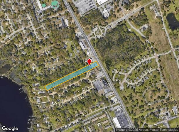
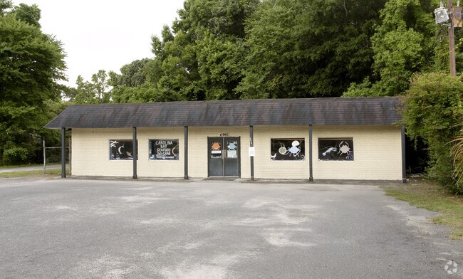
Property Record
6981 Dorchester Rd, North Charleston, SC 29418

NEARBY LISTINGS FOR SALE OR LEASE
Property Detail
6981 Dorchester Rd
404-16-00-069
Riverbend
Commercialnec
SUBDIVISION NAME -RIVERBEND DESCRIPTION -NEAR LAMBS
X
Charleston
45019C0289K
South Carolina
2025
3.30 AC
2024
North Charleston
003109
Charleston/N Charleston
3,600 SF
Charleston-North Charleston, SC
DEMOGRAPHICS near 6981 Dorchester Rd
1 Mile
3 Mile
5 Mile
2024 Total Population
6,607
37,829
126,371
2029 Population
7,108
40,399
136,367
Pop Growth 2024-2029
+ 7.58%
+ 6.79%
+ 7.91%
Average Age
34
37
38
2024 Total Households
2,531
14,875
50,544
HH Growth 2024-2029
+ 7.74%
+ 6.75%
+ 7.74%
Median Household Inc
$44,141
$51,500
$61,704
Avg Household Size
2.30
2.40
2.40
2024 Avg HH Vehicles
1.00
2.00
2.00
Median Home Value
$105,797
$200,296
$251,293
Median Year Built
1992
1988
1990
Nearby Places
Map Layers
Map Styles
 Street
 Aerial
- Restaurants
- Banks
- Shops
- Fitness
- Groceries
PUBLIC TRANSPORTATION
COMMUTER RAIL
Charleston Amtrak Station (Palmetto - Amtrak, Silver Meteor - Amtrak)
DRIVE
WALK
Distance
Charleston Amtrak Station (Palmetto - Amtrak, Silver Meteor - Amtrak)
10 min
6.4 mi
AIRPORT
Charleston AFB/International
DRIVE
WALK
Distance
Charleston AFB/International
4 min
1.7 mi
Freight Ports
North Charleston Terminal
DRIVE
WALK
Distance
North Charleston Terminal
12 min
7.5 mi
SALE & LEASE HISTORY
LISTING DATE
SALE/LEASE

Sep 23, 2016
For Sale
Feb 27, 2017
For Sale
Nearby Properties
Address
Land Use
TOTAL SIZE
Lot Size
Zoning
Address
Land Use
TOTAL SIZE
Lot Size
Zoning
7,200 SF
8.73 AC
Address
Land Use
TOTAL SIZE
Lot Size
Zoning
48,885 SF
5.02 AC
Address
Land Use
TOTAL SIZE
Lot Size
Zoning
126,385 SF
13.45 AC
Address
Land Use
TOTAL SIZE
Lot Size
Zoning
48,400 SF
5.76 AC
Address
Land Use
TOTAL SIZE
Lot Size
Zoning
167,100 SF
8 AC
Address
Land Use
TOTAL SIZE
Lot Size
Zoning
44,300 SF
2.34 AC
Address
Land Use
TOTAL SIZE
Lot Size
Zoning
1.26 AC
Address
Land Use
TOTAL SIZE
Lot Size
Zoning
2,438 SF
33.72 AC
Address
Land Use
TOTAL SIZE
Lot Size
Zoning
14,250 SF
2.08 AC
Address
Land Use
TOTAL SIZE
Lot Size
Zoning
Address
Land Use
TOTAL SIZE
Lot Size
Zoning
194,994 SF
21.28 AC
R-4_DC
Address
Land Use
TOTAL SIZE
Lot Size
Zoning
28,580 SF
7.65 AC
Address
Land Use
TOTAL SIZE
Lot Size
Zoning
1,842 SF
17.11 AC
Address
Land Use
TOTAL SIZE
Lot Size
Zoning
3,200 SF
45.22 AC
Address
Land Use
TOTAL SIZE
Lot Size
Zoning
228,432 SF
12.96 AC
B-2_NC
Address
Land Use
TOTAL SIZE
Lot Size
Zoning
2,527 SF
1.70 AC
Address
Land Use
TOTAL SIZE
Lot Size
Zoning
1,152 SF
3.45 AC
Address
Land Use
TOTAL SIZE
Lot Size
Zoning
10,950 SF
11.35 AC
Address
Land Use
TOTAL SIZE
Lot Size
Zoning
57,030 SF
13.55 AC
Address
Land Use
TOTAL SIZE
Lot Size
Zoning
184,860 SF
46.80 AC
I_DC
Address
Land Use
TOTAL SIZE
Lot Size
Zoning
204.26 AC
Address
Land Use
TOTAL SIZE
Lot Size
Zoning
325,630 SF
45.85 AC
B-2_NC
Address
Land Use
TOTAL SIZE
Lot Size
Zoning
133,535 SF
2.89 AC
Address
Land Use
TOTAL SIZE
Lot Size
Zoning
45,404 SF
67.87 AC
I_DC
Address
Land Use
TOTAL SIZE
Lot Size
Zoning
6,300 SF
0.75 AC
Address
Land Use
TOTAL SIZE
Lot Size
Zoning
135,827 SF
13.38 AC
Address
Land Use
TOTAL SIZE
Lot Size
Zoning
102,768 SF
3.76 AC
Address
Land Use
TOTAL SIZE
Lot Size
Zoning
Address
Land Use
TOTAL SIZE
Lot Size
Zoning
Address
Land Use
TOTAL SIZE
Lot Size
Zoning
The World's #1 Commercial Real Estate Marketplace
Connect with us
© 2025 CoStar Group
The information above has been obtained from sources believed reliable. While we do not doubt its accuracy we have not verified it and make no guarantee, warranty or representation about it. It is your responsibility to independently confirm its accuracy and completeness. Any projections, opinions, assumptions, or estimates used are for example only and do not represent the current or future performance of the property. The value of this transaction to you depends on tax and other factors which should be evaluated by your tax, financial, and legal advisors. You and your advisors should conduct a careful, independent investigation of the property to determine to your satisfaction the suitability of the property for your needs.