Property Record
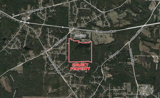
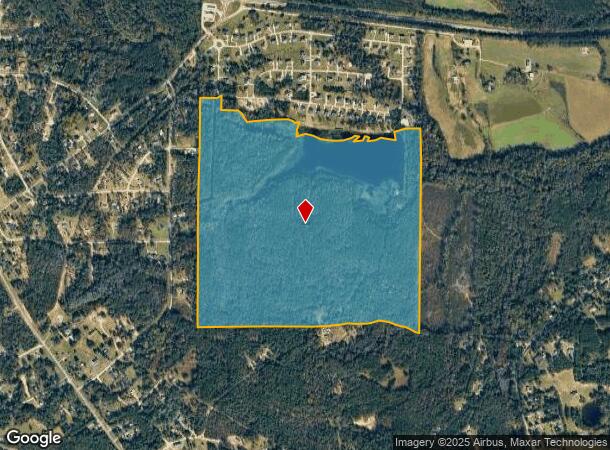
6982 Knoxville Rd, Lizella, GA 31052
NEARBY LISTINGS FOR SALE OR LEASE
Property Detail
6982 Knoxville Rd
Macon-Bibb County, GA
Wenjet Llc
H010-0003
Bibb
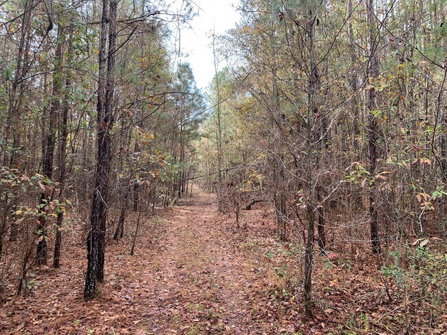
Agriculturalland
Georgia
A
234
13021C0120G
175.30 AC
2025
Outlying Bibb County
2025
Atlanta
013604
DEMOGRAPHICS near 6982 Knoxville Rd
1 Mile
3 Mile
5 Mile
2024 Total Population
895
8,954
33,547
2029 Population
877
8,965
33,323
Pop Growth 2024-2029
(2.01%)
+ 0.12%
(0.67%)
Average Age
43
42
38
2024 Total Households
350
3,309
12,328
HH Growth 2024-2029
(2.00%)
(0.15%)
(0.83%)
Median Household Inc
$77,500
$87,269
$52,173
Avg Household Size
2.60
2.60
2.60
2024 Avg HH Vehicles
3.00
2.00
2.00
Median Home Value
$159,840
$181,041
$150,682
Median Year Built
1983
1993
1983
Nearby Places
Map Layers
Map Styles
 Street
 Aerial
- Restaurants
- Banks
- Shops
- Fitness
- Groceries
SALE & LEASE HISTORY
LISTING DATE
SALE/LEASE

Dec 22, 2021
For Sale
Nearby Properties
Address
Land Use
TOTAL SIZE
Lot Size
Zoning
Address
Land Use
TOTAL SIZE
Lot Size
Zoning
17,812 SF
161.34 AC
A/C-4
Address
Land Use
TOTAL SIZE
Lot Size
Zoning
170,536 SF
51.47 AC
A
Address
Land Use
TOTAL SIZE
Lot Size
Zoning
14,596 SF
9.45 AC
A
Address
Land Use
TOTAL SIZE
Lot Size
Zoning
9,290 SF
28.40 AC
A/C-2
Address
Land Use
TOTAL SIZE
Lot Size
Zoning
99,818 SF
10.98 AC
PDE
Address
Land Use
TOTAL SIZE
Lot Size
Zoning
66,528 SF
11.41 AC
PDR
Address
Land Use
TOTAL SIZE
Lot Size
Zoning
10,000 SF
10.59 AC
PDC
Address
Land Use
TOTAL SIZE
Lot Size
Zoning
16,551 SF
68.86 AC
A
Address
Land Use
TOTAL SIZE
Lot Size
Zoning
12,746 SF
125.02 AC
M-2
Address
Land Use
TOTAL SIZE
Lot Size
Zoning
117,841 SF
18.35 AC
PDC
Address
Land Use
TOTAL SIZE
Lot Size
Zoning
24,390 SF
11.53 AC
PDC
Address
Land Use
TOTAL SIZE
Lot Size
Zoning
10,174 SF
9.21 AC
R-1AAA
Address
Land Use
TOTAL SIZE
Lot Size
Zoning
19,188 SF
4.44 AC
PDC
Address
Land Use
TOTAL SIZE
Lot Size
Zoning
23,232 SF
5.03 AC
C-2
Address
Land Use
TOTAL SIZE
Lot Size
Zoning
8,700 SF
12.39 AC
R-1AAA
Address
Land Use
TOTAL SIZE
Lot Size
Zoning
36,400 SF
3.20 AC
PDE
Address
Land Use
TOTAL SIZE
Lot Size
Zoning
17,818 SF
1.57 AC
PDE
Address
Land Use
TOTAL SIZE
Lot Size
Zoning
2,679 SF
87.16 AC
M-1
Address
Land Use
TOTAL SIZE
Lot Size
Zoning
14,696 SF
5.92 AC
A/PDC
Address
Land Use
TOTAL SIZE
Lot Size
Zoning
1,860 SF
81.54 AC
PDE
Address
Land Use
TOTAL SIZE
Lot Size
Zoning
6,285 SF
2.53 AC
A
Address
Land Use
TOTAL SIZE
Lot Size
Zoning
5,875 SF
2.57 AC
A
Address
Land Use
TOTAL SIZE
Lot Size
Zoning
9,896 SF
4.74 AC
A
Address
Land Use
TOTAL SIZE
Lot Size
Zoning
1,225 SF
71.68 AC
R-1AAA
Address
Land Use
TOTAL SIZE
Lot Size
Zoning
8,140 SF
1.85 AC
A
Address
Land Use
TOTAL SIZE
Lot Size
Zoning
14,256 SF
2.59 AC
C-1
Address
Land Use
TOTAL SIZE
Lot Size
Zoning
7,106 SF
4.43 AC
A
Address
Land Use
TOTAL SIZE
Lot Size
Zoning
3,285 SF
95.01 AC
PDE
Address
Land Use
TOTAL SIZE
Lot Size
Zoning
3.71 AC
PDE
Address
Land Use
TOTAL SIZE
Lot Size
Zoning
8,206 SF
4.57 AC
A
The World's #1 Commercial Real Estate Marketplace
Connect with us
© 2025 CoStar Group
The information above has been obtained from sources believed reliable. While we do not doubt its accuracy we have not verified it and make no guarantee, warranty or representation about it. It is your responsibility to independently confirm its accuracy and completeness. Any projections, opinions, assumptions, or estimates used are for example only and do not represent the current or future performance of the property. The value of this transaction to you depends on tax and other factors which should be evaluated by your tax, financial, and legal advisors. You and your advisors should conduct a careful, independent investigation of the property to determine to your satisfaction the suitability of the property for your needs.