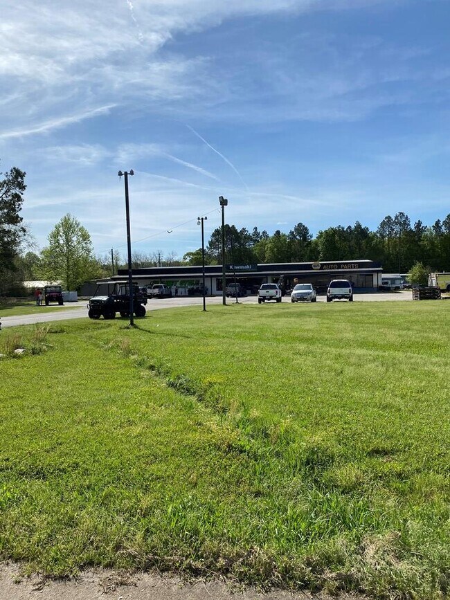
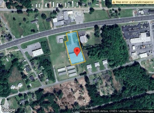
Property Record
6982 Us Highway 280, Claxton, GA 30417
NEARBY LISTINGS FOR SALE OR LEASE
Property Detail
6982 Us Highway 280
Storebuilding
TRACT A2
X
Evans
13267C0125D
Georgia
2024
1.55 AC
2024
Georgia South Area
970200
Other Market Areas
16,800 SF
H10-026-002
DEMOGRAPHICS near 6982 Us Highway 280
1 Mile
3 Mile
5 Mile
2024 Total Population
1,679
5,634
7,855
2029 Population
1,647
5,559
7,757
Pop Growth 2024-2029
(1.91%)
(1.33%)
(1.25%)
Average Age
42
40
40
2024 Total Households
724
2,154
2,979
HH Growth 2024-2029
(1.52%)
(1.49%)
(1.34%)
Median Household Inc
$51,103
$48,531
$51,345
Avg Household Size
2.30
2.40
2.40
2024 Avg HH Vehicles
2.00
2.00
2.00
Median Home Value
$140,740
$122,589
$126,642
Median Year Built
1975
1979
1983
Nearby Places
Map Layers
Map Styles
 Street
 Aerial
- Restaurants
- Banks
- Shops
- Fitness
- Groceries
SALE & LEASE HISTORY
LISTING DATE
SALE/LEASE

Sep 24, 2016
For Sale
Sep 02, 2021
For Sale
Nearby Properties
Address
Land Use
TOTAL SIZE
Lot Size
Zoning
Address
Land Use
TOTAL SIZE
Lot Size
Zoning
49,950 SF
24.04 AC
007
Address
Land Use
TOTAL SIZE
Lot Size
Zoning
84,120 SF
7.83 AC
002
Address
Land Use
TOTAL SIZE
Lot Size
Zoning
72,900 SF
10 AC
002
Address
Land Use
TOTAL SIZE
Lot Size
Zoning
75.88 AC
UNZONED RU
Address
Land Use
TOTAL SIZE
Lot Size
Zoning
59.18 AC
UNZONED RU
Address
Land Use
TOTAL SIZE
Lot Size
Zoning
7.87 AC
UNZONED RU
Address
Land Use
TOTAL SIZE
Lot Size
Zoning
10,000 SF
6.30 AC
UNZONED RU
Address
Land Use
TOTAL SIZE
Lot Size
Zoning
1,200 SF
3.60 AC
COMMERCIAL
Address
Land Use
TOTAL SIZE
Lot Size
Zoning
2,720 SF
56.94 AC
007
Address
Land Use
TOTAL SIZE
Lot Size
Zoning
11,700 SF
379.83 AC
UNZONED RU
Address
Land Use
TOTAL SIZE
Lot Size
Zoning
4.08 AC
COMMERCIAL
Address
Land Use
TOTAL SIZE
Lot Size
Zoning
5,304 SF
22.46 AC
UNZONED RU
Address
Land Use
TOTAL SIZE
Lot Size
Zoning
8,362 SF
7.15 AC
002
Address
Land Use
TOTAL SIZE
Lot Size
Zoning
828 SF
4.11 AC
COMMERCIAL
Address
Land Use
TOTAL SIZE
Lot Size
Zoning
23,211 SF
2.16 AC
002
Address
Land Use
TOTAL SIZE
Lot Size
Zoning
11,322 SF
1.87 AC
COMMERCIAL
Address
Land Use
TOTAL SIZE
Lot Size
Zoning
9,525 SF
1.25 AC
COMMERCIAL
Address
Land Use
TOTAL SIZE
Lot Size
Zoning
5.87 AC
UNZONED RU
Address
Land Use
TOTAL SIZE
Lot Size
Zoning
7.58 AC
UNZONED RU
Address
Land Use
TOTAL SIZE
Lot Size
Zoning
17,472 SF
3.34 AC
COMMERCIAL
Address
Land Use
TOTAL SIZE
Lot Size
Zoning
1.45 AC
COMMERCIAL
Address
Land Use
TOTAL SIZE
Lot Size
Zoning
8,492 SF
1.29 AC
COMMERCIAL
Address
Land Use
TOTAL SIZE
Lot Size
Zoning
6,186 SF
1.11 AC
002
Address
Land Use
TOTAL SIZE
Lot Size
Zoning
13,912 SF
1.03 AC
COMMERCIAL
Address
Land Use
TOTAL SIZE
Lot Size
Zoning
17,160 SF
7 AC
005
Address
Land Use
TOTAL SIZE
Lot Size
Zoning
18,036 SF
2.09 AC
002
Address
Land Use
TOTAL SIZE
Lot Size
Zoning
7,662 SF
0.31 AC
COMMERCIAL
Address
Land Use
TOTAL SIZE
Lot Size
Zoning
11,310 SF
1.03 AC
001
Address
Land Use
TOTAL SIZE
Lot Size
Zoning
8,520 SF
8.75 AC
UNZONED RU
The World's #1 Commercial Real Estate Marketplace
Connect with us
© 2025 CoStar Group
The information above has been obtained from sources believed reliable. While we do not doubt its accuracy we have not verified it and make no guarantee, warranty or representation about it. It is your responsibility to independently confirm its accuracy and completeness. Any projections, opinions, assumptions, or estimates used are for example only and do not represent the current or future performance of the property. The value of this transaction to you depends on tax and other factors which should be evaluated by your tax, financial, and legal advisors. You and your advisors should conduct a careful, independent investigation of the property to determine to your satisfaction the suitability of the property for your needs.