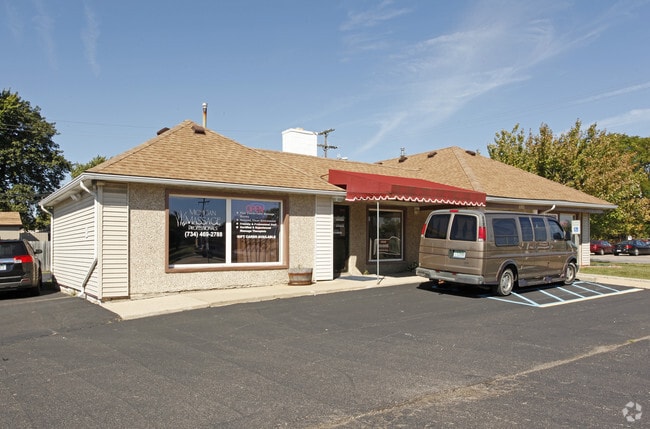
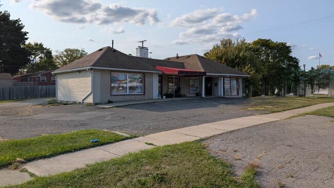
Property Record
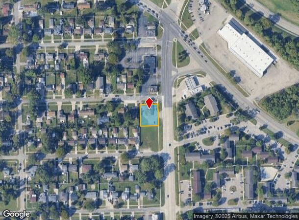
6985 Merriman Rd, Garden City, MI 48135
This Property Is For Sale
NEARBY LISTINGS FOR SALE OR LEASE
Property Detail
6985 Merriman Rd
Detroit-Warren-Dearborn, MI
Folkers Garden City Acres No 21
35-001-01-3261-000
10A3261 TO 3266 LOTS 3261 TO 3266 INCL ALSO E 1/2 ADJ VAC ALLEY FOLKERS GARDEN CITY ACRES SUB NO. 21 T2S R9E L57 P39 WCR
Medicalbuilding
Wayne
X
Michigan
26163C0230E
3261
2024
0.32 AC
2025
Southern I-275 Corridor
569400
Detroit
1,759 SF
DEMOGRAPHICS near 6985 Merriman Rd
1 Mile
3 Mile
5 Mile
2024 Total Population
13,183
113,110
275,753
2029 Population
12,561
108,621
265,096
Pop Growth 2024-2029
(4.72%)
(3.97%)
(3.86%)
Average Age
41
41
41
2024 Total Households
5,792
47,919
111,993
HH Growth 2024-2029
(4.82%)
(4.00%)
(3.91%)
Median Household Inc
$62,324
$63,495
$65,267
Avg Household Size
2.20
2.30
2.40
2024 Avg HH Vehicles
2.00
2.00
2.00
Median Home Value
$154,256
$161,389
$172,638
Median Year Built
1958
1958
1959
Nearby Places
Map Layers
Map Styles
 Street
 Aerial
- Restaurants
- Banks
- Shops
- Fitness
- Groceries
PUBLIC TRANSPORTATION
AIRPORT
Detroit Metro Wayne County
DRIVE
WALK
Distance
Detroit Metro Wayne County
21 min
10.6 mi
Windsor International
DRIVE
WALK
Distance
Windsor International
50 min
31.2 mi
Nearby Properties
Address
Land Use
TOTAL SIZE
Lot Size
Zoning
Address
Land Use
TOTAL SIZE
Lot Size
Zoning
741,173 SF
63.81 AC
Address
Land Use
TOTAL SIZE
Lot Size
Zoning
1,316,911 SF
72.87 AC
M-1
Address
Land Use
TOTAL SIZE
Lot Size
Zoning
480,910 SF
26.32 AC
Address
Land Use
TOTAL SIZE
Lot Size
Zoning
395,148 SF
9.67 AC
Address
Land Use
TOTAL SIZE
Lot Size
Zoning
1,156,275 SF
75.88 AC
M-2
Address
Land Use
TOTAL SIZE
Lot Size
Zoning
1,013,885 SF
36.48 AC
M-1
Address
Land Use
TOTAL SIZE
Lot Size
Zoning
176,396 SF
11.76 AC
Address
Land Use
TOTAL SIZE
Lot Size
Zoning
188,958 SF
7.71 AC
Address
Land Use
TOTAL SIZE
Lot Size
Zoning
286,188 SF
40.21 AC
Address
Land Use
TOTAL SIZE
Lot Size
Zoning
285,136 SF
15.28 AC
Address
Land Use
TOTAL SIZE
Lot Size
Zoning
206,130 SF
14.12 AC
Address
Land Use
TOTAL SIZE
Lot Size
Zoning
399,770 SF
34.90 AC
M-2
Address
Land Use
TOTAL SIZE
Lot Size
Zoning
Address
Land Use
TOTAL SIZE
Lot Size
Zoning
121,420 SF
16.01 AC
C-2
Address
Land Use
TOTAL SIZE
Lot Size
Zoning
177,268 SF
17.11 AC
Address
Land Use
TOTAL SIZE
Lot Size
Zoning
197,774 SF
11.72 AC
Address
Land Use
TOTAL SIZE
Lot Size
Zoning
232,858 SF
39.67 AC
Address
Land Use
TOTAL SIZE
Lot Size
Zoning
170,275 SF
16.53 AC
Address
Land Use
TOTAL SIZE
Lot Size
Zoning
1,529,287 SF
76.96 AC
M-1
Address
Land Use
TOTAL SIZE
Lot Size
Zoning
137,400 SF
11.27 AC
Address
Land Use
TOTAL SIZE
Lot Size
Zoning
196,930 SF
9.93 AC
Address
Land Use
TOTAL SIZE
Lot Size
Zoning
205,368 SF
20.22 AC
C-2
Address
Land Use
TOTAL SIZE
Lot Size
Zoning
282,088 SF
14.34 AC
M-2
Address
Land Use
TOTAL SIZE
Lot Size
Zoning
154,018 SF
11.04 AC
Address
Land Use
TOTAL SIZE
Lot Size
Zoning
176,300 SF
12.52 AC
Address
Land Use
TOTAL SIZE
Lot Size
Zoning
166,030 SF
10.40 AC
Address
Land Use
TOTAL SIZE
Lot Size
Zoning
102,089 SF
10.94 AC
C-2
Address
Land Use
TOTAL SIZE
Lot Size
Zoning
244,838 SF
8.93 AC
M-1
Address
Land Use
TOTAL SIZE
Lot Size
Zoning
182,700 SF
20.45 AC
C-2
Address
Land Use
TOTAL SIZE
Lot Size
Zoning
138,541 SF
8.65 AC
The World's #1 Commercial Real Estate Marketplace
Connect with us
© 2025 CoStar Group
The information above has been obtained from sources believed reliable. While we do not doubt its accuracy we have not verified it and make no guarantee, warranty or representation about it. It is your responsibility to independently confirm its accuracy and completeness. Any projections, opinions, assumptions, or estimates used are for example only and do not represent the current or future performance of the property. The value of this transaction to you depends on tax and other factors which should be evaluated by your tax, financial, and legal advisors. You and your advisors should conduct a careful, independent investigation of the property to determine to your satisfaction the suitability of the property for your needs.