Property Record
6985 Raeford Rd, Fayetteville, NC 28304


This Property Is For Sale
NEARBY LISTINGS FOR SALE OR LEASE
Property Detail
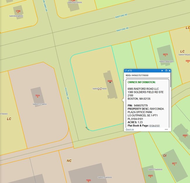
6985 Raeford Rd
Fayetteville, NC
Raeford Rd/Stric Bg Rd To Cc L
9496-57-5779
RAYCONDA PLAZA OFFICE PARK LO:OUTPARCEL SE:1-PT1 PL:0104-0101
Commercialacreage
Cumberland
X
North Carolina
3710949600J
5779
2025
1.23 AC
2025
Southwest Fayetteville
003205
Fayetteville
DEMOGRAPHICS near 6985 Raeford Rd
1 Mile
3 Mile
5 Mile
2024 Total Population
6,118
62,191
142,405
2029 Population
6,063
62,008
142,745
Pop Growth 2024-2029
(0.90%)
(0.29%)
+ 0.24%
Average Age
38
35
36
2024 Total Households
2,302
25,011
56,836
HH Growth 2024-2029
(0.91%)
(0.28%)
+ 0.20%
Median Household Inc
$67,472
$54,937
$56,567
Avg Household Size
2.60
2.40
2.40
2024 Avg HH Vehicles
2.00
2.00
2.00
Median Home Value
$192,039
$155,371
$157,930
Median Year Built
1989
1989
1988
Nearby Places
Map Layers
Map Styles
 Street
 Aerial
- Restaurants
- Banks
- Shops
- Fitness
- Groceries
PUBLIC TRANSPORTATION
COMMUTER RAIL
Fayetteville Amtrak Station (Palmetto - Amtrak, Silver Meteor - Amtrak)
DRIVE
WALK
Distance
Fayetteville Amtrak Station (Palmetto - Amtrak, Silver Meteor - Amtrak)
14 min
8.0 mi
AIRPORT
Fayetteville Regional/Grannis Field
DRIVE
WALK
Distance
Fayetteville Regional/Grannis Field
16 min
10.3 mi
Freight Ports
Port of Wilmington
DRIVE
WALK
Distance
Port of Wilmington
134 min
97.0 mi
Nearby Properties
Address
Land Use
TOTAL SIZE
Lot Size
Zoning
Address
Land Use
TOTAL SIZE
Lot Size
Zoning
64,137 SF
40.24 AC
OI
Address
Land Use
TOTAL SIZE
Lot Size
Zoning
2,049 SF
25.22 AC
MR5
Address
Land Use
TOTAL SIZE
Lot Size
Zoning
2,064 SF
26.91 AC
R6CZ
Address
Land Use
TOTAL SIZE
Lot Size
Zoning
2,049 SF
18.07 AC
MR5
Address
Land Use
TOTAL SIZE
Lot Size
Zoning
56,747 SF
88.76 AC
AR
Address
Land Use
TOTAL SIZE
Lot Size
Zoning
5,136 SF
21.21 AC
R6C
Address
Land Use
TOTAL SIZE
Lot Size
Zoning
54,316 SF
28.64 AC
CC
Address
Land Use
TOTAL SIZE
Lot Size
Zoning
2,370 SF
15.66 AC
PND
Address
Land Use
TOTAL SIZE
Lot Size
Zoning
5,136 SF
19.84 AC
SF6
Address
Land Use
TOTAL SIZE
Lot Size
Zoning
1,722 SF
24.45 AC
MR5
Address
Land Use
TOTAL SIZE
Lot Size
Zoning
4,582 SF
23.32 AC
NC
Address
Land Use
TOTAL SIZE
Lot Size
Zoning
4,582 SF
21.10 AC
MR5
Address
Land Use
TOTAL SIZE
Lot Size
Zoning
1,064 SF
9.88 AC
R5C
Address
Land Use
TOTAL SIZE
Lot Size
Zoning
2,114 SF
20.70 AC
MR5
Address
Land Use
TOTAL SIZE
Lot Size
Zoning
5,136 SF
15.43 AC
R6C
Address
Land Use
TOTAL SIZE
Lot Size
Zoning
2,314 SF
21.82 AC
MR5
Address
Land Use
TOTAL SIZE
Lot Size
Zoning
1,461 SF
12.42 AC
MR5
Address
Land Use
TOTAL SIZE
Lot Size
Zoning
66,637 SF
25.83 AC
RR
Address
Land Use
TOTAL SIZE
Lot Size
Zoning
26,016 SF
30.11 AC
SF10
Address
Land Use
TOTAL SIZE
Lot Size
Zoning
1,289 SF
37.83 AC
MR5
Address
Land Use
TOTAL SIZE
Lot Size
Zoning
6,232 SF
12.78 AC
MR5
Address
Land Use
TOTAL SIZE
Lot Size
Zoning
203,515 SF
22.92 AC
CC
Address
Land Use
TOTAL SIZE
Lot Size
Zoning
3,840 SF
17.54 AC
SF10-SGLFA
Address
Land Use
TOTAL SIZE
Lot Size
Zoning
2,236 SF
17.33 AC
CC
Address
Land Use
TOTAL SIZE
Lot Size
Zoning
58.63 AC
AR
Address
Land Use
TOTAL SIZE
Lot Size
Zoning
3,411 SF
13.09 AC
MR5
Address
Land Use
TOTAL SIZE
Lot Size
Zoning
4,320 SF
15.17 AC
MR5
Address
Land Use
TOTAL SIZE
Lot Size
Zoning
4,549 SF
29.20 AC
MR5
Address
Land Use
TOTAL SIZE
Lot Size
Zoning
127,753 SF
8.46 AC
CC
Address
Land Use
TOTAL SIZE
Lot Size
Zoning
139,767 SF
16 AC
CC
The World's #1 Commercial Real Estate Marketplace
Connect with us
© 2026 CoStar Group
The information above has been obtained from sources believed reliable. While we do not doubt its accuracy we have not verified it and make no guarantee, warranty or representation about it. It is your responsibility to independently confirm its accuracy and completeness. Any projections, opinions, assumptions, or estimates used are for example only and do not represent the current or future performance of the property. The value of this transaction to you depends on tax and other factors which should be evaluated by your tax, financial, and legal advisors. You and your advisors should conduct a careful, independent investigation of the property to determine to your satisfaction the suitability of the property for your needs.