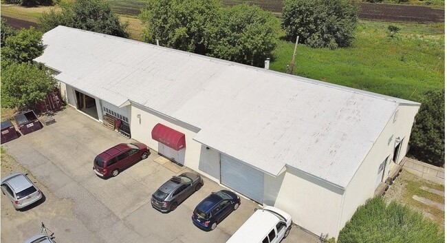
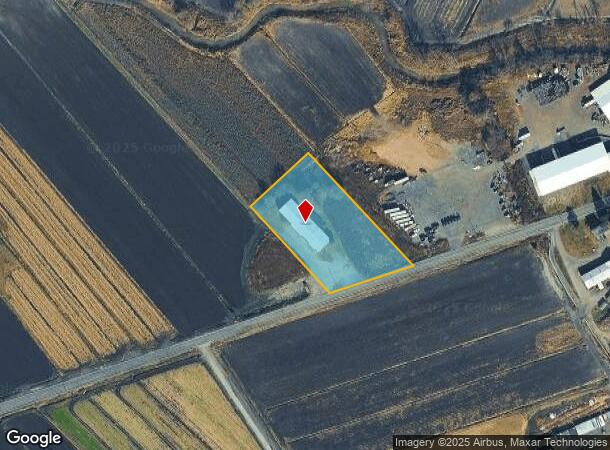
Property Record
699 Pulaski Hwy, Goshen, NY 10924
NEARBY LISTINGS FOR SALE OR LEASE
Property Detail
699 Pulaski Hwy
335489-006-000-0001-006.200-0000
PT LT 7 PAWELSKI SUB
Warehouse
Orange
AE
New York
36071C0433E
6.200
2024
2.20 AC
2024
Orange County
014501
Northern New Jersey
9,480 SF
New York-Jersey City-White Plains, NY-NJ
DEMOGRAPHICS near 699 Pulaski Hwy
1 Mile
3 Mile
5 Mile
2024 Total Population
249
3,130
16,494
2029 Population
251
3,168
16,739
Pop Growth 2024-2029
+ 0.80%
+ 1.21%
+ 1.49%
Average Age
39
42
43
2024 Total Households
83
1,097
5,799
HH Growth 2024-2029
+ 1.20%
+ 1.28%
+ 1.59%
Median Household Inc
$141,346
$125,709
$124,079
Avg Household Size
2.90
2.80
2.70
2024 Avg HH Vehicles
3.00
2.00
2.00
Median Home Value
$450,000
$436,315
$401,503
Median Year Built
1980
1975
1977
Nearby Places
- Restaurants
- Banks
- Shops
- Fitness
- Groceries
PUBLIC TRANSPORTATION
AIRPORT
New York Stewart International
DRIVE
WALK
Distance
New York Stewart International
41 min
23.6 mi
Freight Ports
Port Newark Container Terminal
DRIVE
WALK
Distance
Port Newark Container Terminal
96 min
61.2 mi
SALE & LEASE HISTORY
LISTING DATE
SALE/LEASE

Aug 13, 2020
For Sale
Nearby Properties
Address
Land Use
TOTAL SIZE
Lot Size
Zoning
Address
Land Use
TOTAL SIZE
Lot Size
Zoning
28,609 SF
96.71 AC
04200
Address
Land Use
TOTAL SIZE
Lot Size
Zoning
169,650 SF
24.20 AC
04200
Address
Land Use
TOTAL SIZE
Lot Size
Zoning
81,518 SF
35.90 AC
00215
Address
Land Use
TOTAL SIZE
Lot Size
Zoning
26,496 SF
89.40 AC
04200
Address
Land Use
TOTAL SIZE
Lot Size
Zoning
50,224 SF
37.50 AC
04200
Address
Land Use
TOTAL SIZE
Lot Size
Zoning
39,990 SF
6.40 AC
04200
Address
Land Use
TOTAL SIZE
Lot Size
Zoning
57,540 SF
4.10 AC
AB
Address
Land Use
TOTAL SIZE
Lot Size
Zoning
25,600 SF
119.80 AC
04200
Address
Land Use
TOTAL SIZE
Lot Size
Zoning
14,918 SF
10.70 AC
04200
Address
Land Use
TOTAL SIZE
Lot Size
Zoning
29,884 SF
9.10 AC
04200
Address
Land Use
TOTAL SIZE
Lot Size
Zoning
12,960 SF
12.20 AC
04200
Address
Land Use
TOTAL SIZE
Lot Size
Zoning
2,688 SF
80.61 AC
AP
Address
Land Use
TOTAL SIZE
Lot Size
Zoning
17,200 SF
5.90 AC
04200
Address
Land Use
TOTAL SIZE
Lot Size
Zoning
7,473 SF
7.10 AC
04200
Address
Land Use
TOTAL SIZE
Lot Size
Zoning
21,291 SF
17.80 AC
04200
Address
Land Use
TOTAL SIZE
Lot Size
Zoning
12,202 SF
1.90 AC
04100
Address
Land Use
TOTAL SIZE
Lot Size
Zoning
5,094 SF
86.60 AC
AB-AP
Address
Land Use
TOTAL SIZE
Lot Size
Zoning
624 SF
17.30 AC
04200
Address
Land Use
TOTAL SIZE
Lot Size
Zoning
13,440 SF
1.40 AC
04200
Address
Land Use
TOTAL SIZE
Lot Size
Zoning
198.50 AC
AP
Address
Land Use
TOTAL SIZE
Lot Size
Zoning
2,642 SF
79.70 AC
04200
Address
Land Use
TOTAL SIZE
Lot Size
Zoning
149.50 AC
AP
Address
Land Use
TOTAL SIZE
Lot Size
Zoning
9,234 SF
1.40 AC
04100
Address
Land Use
TOTAL SIZE
Lot Size
Zoning
8,800 SF
5 AC
04200
Address
Land Use
TOTAL SIZE
Lot Size
Zoning
6,746 SF
51.60 AC
00220
Address
Land Use
TOTAL SIZE
Lot Size
Zoning
169.80 AC
AP
Address
Land Use
TOTAL SIZE
Lot Size
Zoning
3,113 SF
0.92 AC
04200
Address
Land Use
TOTAL SIZE
Lot Size
Zoning
4,144 SF
19.80 AC
04200
Address
Land Use
TOTAL SIZE
Lot Size
Zoning
13,369 SF
43.70 AC
00220
Address
Land Use
TOTAL SIZE
Lot Size
Zoning
155 AC
AP
The World's #1 Commercial Real Estate Marketplace
Connect with us
© 2025 CoStar Group
The information above has been obtained from sources believed reliable. While we do not doubt its accuracy we have not verified it and make no guarantee, warranty or representation about it. It is your responsibility to independently confirm its accuracy and completeness. Any projections, opinions, assumptions, or estimates used are for example only and do not represent the current or future performance of the property. The value of this transaction to you depends on tax and other factors which should be evaluated by your tax, financial, and legal advisors. You and your advisors should conduct a careful, independent investigation of the property to determine to your satisfaction the suitability of the property for your needs.