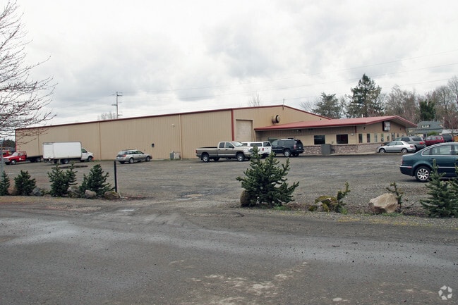
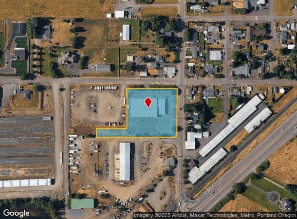
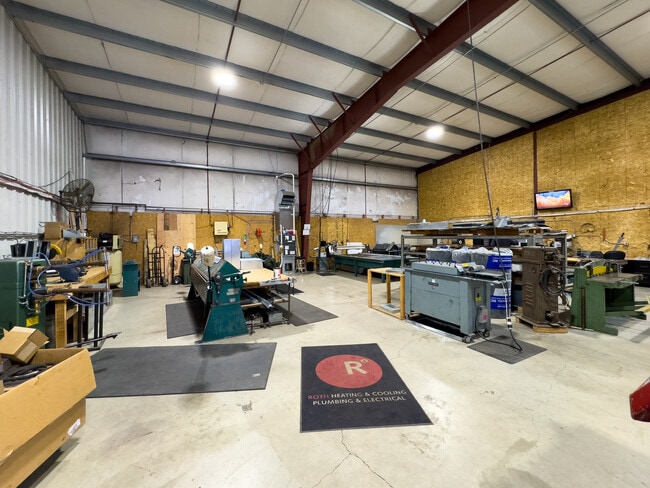
Property Record
6990 S Anderson Rd, Aurora, OR 97002

NEARBY LISTINGS FOR SALE OR LEASE
Property Detail
6990 S Anderson Rd
Portland-Vancouver-Hillsboro, OR-WA
Partition Plat
01004763
1993-134 PARTITION PLAT PARCEL 1
Industrialgeneral
Clackamas
X
Oregon
41067C0650E
a
2025
2 AC
2025
SE Outlying
022800
Portland
1,016 SF
DEMOGRAPHICS near 6990 S Anderson Rd
1 Mile
3 Mile
5 Mile
2024 Total Population
293
23,277
46,704
2029 Population
282
23,818
47,694
Pop Growth 2024-2029
(3.75%)
+ 2.32%
+ 2.12%
Average Age
43
43
42
2024 Total Households
110
8,627
18,086
HH Growth 2024-2029
(3.64%)
+ 2.32%
+ 2.13%
Median Household Inc
$41,666
$84,524
$83,491
Avg Household Size
2.70
2.60
2.50
2024 Avg HH Vehicles
2.00
2.00
2.00
Median Home Value
$1,015,957
$452,305
$491,884
Median Year Built
1986
1989
1990
Nearby Places
Map Layers
Map Styles
 Street
 Aerial
- Restaurants
- Banks
- Shops
- Fitness
- Groceries
PUBLIC TRANSPORTATION
COMMUTER RAIL
Wilsonville (Westside Express Service - Tri-County Metropolitan Transportation District of Oregon Rail (TriMet Rail))
DRIVE
WALK
Distance
Wilsonville (Westside Express Service - Tri-County Metropolitan Transportation District of Oregon Rail (TriMet Rail))
14 min
7.1 mi
AIRPORT
Portland International
DRIVE
WALK
Distance
Portland International
46 min
29.5 mi
Freight Ports
Port of Portland
DRIVE
WALK
Distance
Port of Portland
38 min
25.9 mi
SALE & LEASE HISTORY
LISTING DATE
SALE/LEASE

Mar 06, 2025
For Sale
Nearby Properties
Address
Land Use
TOTAL SIZE
Lot Size
Zoning
Address
Land Use
TOTAL SIZE
Lot Size
Zoning
165,375 SF
27.47 AC
P-LU
Address
Land Use
TOTAL SIZE
Lot Size
Zoning
1,432 SF
12.96 AC
CM
Address
Land Use
TOTAL SIZE
Lot Size
Zoning
10 AC
M2
Address
Land Use
TOTAL SIZE
Lot Size
Zoning
19.24 AC
P
Address
Land Use
TOTAL SIZE
Lot Size
Zoning
4.88 AC
R1.5
Address
Land Use
TOTAL SIZE
Lot Size
Zoning
9.26 AC
M1
Address
Land Use
TOTAL SIZE
Lot Size
Zoning
15.17 AC
M2
Address
Land Use
TOTAL SIZE
Lot Size
Zoning
Address
Land Use
TOTAL SIZE
Lot Size
Zoning
1 SF
7 AC
C2
Address
Land Use
TOTAL SIZE
Lot Size
Zoning
828 SF
0.74 AC
C1
Address
Land Use
TOTAL SIZE
Lot Size
Zoning
6.11 AC
M1
Address
Land Use
TOTAL SIZE
Lot Size
Zoning
7 AC
M2
Address
Land Use
TOTAL SIZE
Lot Size
Zoning
13.91 AC
M1
Address
Land Use
TOTAL SIZE
Lot Size
Zoning
3 AC
CM
Address
Land Use
TOTAL SIZE
Lot Size
Zoning
4.39 AC
R2
Address
Land Use
TOTAL SIZE
Lot Size
Zoning
4.53 AC
P
Address
Land Use
TOTAL SIZE
Lot Size
Zoning
11.34 AC
M1
Address
Land Use
TOTAL SIZE
Lot Size
Zoning
Address
Land Use
TOTAL SIZE
Lot Size
Zoning
1,863 SF
0.32 AC
R2
Address
Land Use
TOTAL SIZE
Lot Size
Zoning
47.55 AC
M1
Address
Land Use
TOTAL SIZE
Lot Size
Zoning
42,972 SF
0.99 AC
P
Address
Land Use
TOTAL SIZE
Lot Size
Zoning
5 AC
M2
Address
Land Use
TOTAL SIZE
Lot Size
Zoning
Address
Land Use
TOTAL SIZE
Lot Size
Zoning
5.84 AC
Address
Land Use
TOTAL SIZE
Lot Size
Zoning
4.89 AC
M1
Address
Land Use
TOTAL SIZE
Lot Size
Zoning
7.95 AC
R2
Address
Land Use
TOTAL SIZE
Lot Size
Zoning
Address
Land Use
TOTAL SIZE
Lot Size
Zoning
16.26 AC
M1
Address
Land Use
TOTAL SIZE
Lot Size
Zoning
3 AC
M2
Address
Land Use
TOTAL SIZE
Lot Size
Zoning
20 SF
0.73 AC
P
The World's #1 Commercial Real Estate Marketplace
Connect with us
© 2026 CoStar Group
The information above has been obtained from sources believed reliable. While we do not doubt its accuracy we have not verified it and make no guarantee, warranty or representation about it. It is your responsibility to independently confirm its accuracy and completeness. Any projections, opinions, assumptions, or estimates used are for example only and do not represent the current or future performance of the property. The value of this transaction to you depends on tax and other factors which should be evaluated by your tax, financial, and legal advisors. You and your advisors should conduct a careful, independent investigation of the property to determine to your satisfaction the suitability of the property for your needs.