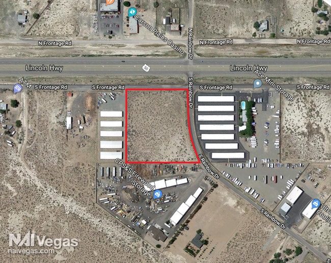
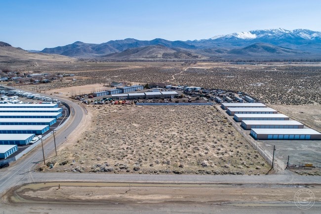
Property Record
6999 Us Highway 50 E, Dayton, NV 89403

NEARBY LISTINGS FOR SALE OR LEASE
Property Detail
6999 Us Highway 50 E
Fernley, NV
Pinenut View
019-193-05
27-17-22 FR SW4
Commercialacreage
Lyon
X
Nevada
32019C0292F
54
2026
1.51 AC
2025
Lyon County
960304
Reno/Sparks
DEMOGRAPHICS near 6999 Us Highway 50 E
1 Mile
3 Mile
5 Mile
2024 Total Population
1,500
8,041
13,149
2029 Population
1,664
8,834
14,396
Pop Growth 2024-2029
+ 10.93%
+ 9.86%
+ 9.48%
Average Age
44
44
44
2024 Total Households
552
3,052
5,078
HH Growth 2024-2029
+ 10.87%
+ 9.73%
+ 9.41%
Median Household Inc
$78,049
$82,017
$81,001
Avg Household Size
2.70
2.60
2.60
2024 Avg HH Vehicles
3.00
3.00
3.00
Median Home Value
$338,541
$348,746
$353,076
Median Year Built
2006
2002
2001
Nearby Places
Map Layers
Map Styles
 Street
 Aerial
- Restaurants
- Banks
- Shops
- Fitness
- Groceries
PUBLIC TRANSPORTATION
AIRPORT
Reno/Tahoe International
DRIVE
WALK
Distance
Reno/Tahoe International
71 min
33.7 mi
Freight Ports
Port of Stockton
DRIVE
WALK
Distance
Port of Stockton
244 min
169.7 mi
SALE & LEASE HISTORY
LISTING DATE
SALE/LEASE

Sep 19, 2017
For Sale
Feb 27, 2019
For Sale
Apr 11, 2019
For Sale
Nearby Properties
Address
Land Use
TOTAL SIZE
Lot Size
Zoning
Address
Land Use
TOTAL SIZE
Lot Size
Zoning
50,495 SF
10.76 AC
E1
Address
Land Use
TOTAL SIZE
Lot Size
Zoning
24.60 AC
MULT
Address
Land Use
TOTAL SIZE
Lot Size
Zoning
9,600 SF
4.50 AC
C2
Address
Land Use
TOTAL SIZE
Lot Size
Zoning
4,644 SF
1.18 AC
C2
Address
Land Use
TOTAL SIZE
Lot Size
Zoning
1,620 SF
2.81 AC
C2
Address
Land Use
TOTAL SIZE
Lot Size
Zoning
78.88 AC
E1
Address
Land Use
TOTAL SIZE
Lot Size
Zoning
2,400 SF
3.01 AC
C2
Address
Land Use
TOTAL SIZE
Lot Size
Zoning
7,771 SF
1.21 AC
C2
Address
Land Use
TOTAL SIZE
Lot Size
Zoning
10,125 SF
2.03 AC
C2
Address
Land Use
TOTAL SIZE
Lot Size
Zoning
7,488 SF
5.07 AC
C2
Address
Land Use
TOTAL SIZE
Lot Size
Zoning
67.47 AC
E1
Address
Land Use
TOTAL SIZE
Lot Size
Zoning
2,301 SF
4.98 AC
C2
Address
Land Use
TOTAL SIZE
Lot Size
Zoning
10,800 SF
2.73 AC
C2
Address
Land Use
TOTAL SIZE
Lot Size
Zoning
5,880 SF
2.70 AC
C2
Address
Land Use
TOTAL SIZE
Lot Size
Zoning
4,000 SF
3.59 AC
C1
Address
Land Use
TOTAL SIZE
Lot Size
Zoning
0.51 AC
RR2T
Address
Land Use
TOTAL SIZE
Lot Size
Zoning
4,500 SF
5.71 AC
P
Address
Land Use
TOTAL SIZE
Lot Size
Zoning
5,715 SF
1.02 AC
C1
Address
Land Use
TOTAL SIZE
Lot Size
Zoning
5.75 AC
C2
Address
Land Use
TOTAL SIZE
Lot Size
Zoning
729 SF
28.50 AC
RR2T
Address
Land Use
TOTAL SIZE
Lot Size
Zoning
3,264 SF
300 AC
I-2;INDUST
Address
Land Use
TOTAL SIZE
Lot Size
Zoning
1,953 SF
0.27 AC
E1
Address
Land Use
TOTAL SIZE
Lot Size
Zoning
34.76 AC
E1
Address
Land Use
TOTAL SIZE
Lot Size
Zoning
11,800 SF
3.42 AC
ME
Address
Land Use
TOTAL SIZE
Lot Size
Zoning
6,600 SF
2.75 AC
C2
Address
Land Use
TOTAL SIZE
Lot Size
Zoning
2,204 SF
0.32 AC
E1
Address
Land Use
TOTAL SIZE
Lot Size
Zoning
53.02 AC
SR-2
Address
Land Use
TOTAL SIZE
Lot Size
Zoning
4,800 SF
1.51 AC
C2
Address
Land Use
TOTAL SIZE
Lot Size
Zoning
1,927 SF
27.21 AC
RR2T
The World's #1 Commercial Real Estate Marketplace
Connect with us
© 2025 CoStar Group
The information above has been obtained from sources believed reliable. While we do not doubt its accuracy we have not verified it and make no guarantee, warranty or representation about it. It is your responsibility to independently confirm its accuracy and completeness. Any projections, opinions, assumptions, or estimates used are for example only and do not represent the current or future performance of the property. The value of this transaction to you depends on tax and other factors which should be evaluated by your tax, financial, and legal advisors. You and your advisors should conduct a careful, independent investigation of the property to determine to your satisfaction the suitability of the property for your needs.