Property Record
6Th Ave, Mansfield, TX 76063
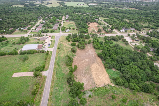
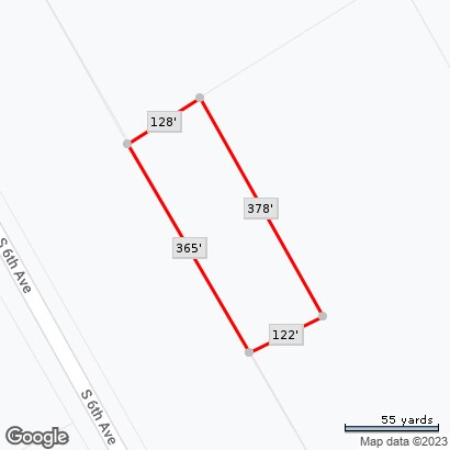
Property Detail
6Th Ave
Dallas-Fort Worth-Arlington, TX
HANKS, THOMAS J SURVEY ABSTRACT 644 TRACT 11C
42298871
TARRANT
Residentialacreage
Texas
B and X Area of moderate flood hazard, usually the area between the limits of the 100-year and 500-year floods.
1.04 AC
2024
Southeast Ft Worth
2025
Dallas/Ft Worth
111306
NEARBY LISTINGS FOR SALE OR LEASE
-
-
-
-
Farm to Market Road 157 Hwy @ Watson Branch Lane
Mansfield, TX 76063
Rent Upon Request
1.38 AC Lots
Land
-
-
-
-
-
-
-
-
View all Mansfield listings for sale on LoopNet.com
DEMOGRAPHICS near 6Th Ave
1 mile
3 mile
5 mile
2024 Total Population
2,801
34,922
105,209
2029 Population
3,053
37,844
113,333
Pop Growth 2024-2029
+ 9.00%
+ 8.37%
+ 7.72%
Average Age
38
38
38
2024 Total Households
1,020
11,990
34,847
HH Growth 2024-2029
+ 9.02%
+ 8.46%
+ 7.85%
Median Household Inc
$57,905
$85,945
$109,695
Avg Household Size
2.60
2.90
3.00
2024 Avg HH Vehicles
2.00
2.00
2.00
Median Home Value
$360,759
$377,039
$406,198
Median Year Built
2006
2001
2003
Nearby Places
Map Layers
Map Styles
 Street
 Aerial
Transit
 Traffic
 Biking
Places
Listings with unknown addresses are not visible on the map
- Restaurants
- Banks
- Shops
- Fitness
- Groceries
PUBLIC TRANSPORTATION
AIRPORT
Dallas-Fort Worth International
Drive
Walk
Distance
Dallas-Fort Worth International
43 min
29.4 mi
Dallas Love Field
Drive
Walk
Distance
Dallas Love Field
53 min
38.0 mi
Freight Ports
Port of Shreveport
Drive
Walk
Distance
Port of Shreveport
244 min
223.7 mi
SALE & LEASE HISTORY
LISTING DATE
SALE/LEASE

Jun 07, 2022
For Sale
Nearby Properties
Address
Land Use
TOTAL SIZE
Lot Size
Zoning
Address
Land Use
TOTAL SIZE
Lot Size
Zoning
426,667 SF
12.87 AC
Address
Land Use
TOTAL SIZE
Lot Size
Zoning
348,951 SF
18.66 AC
Address
Land Use
TOTAL SIZE
Lot Size
Zoning
317,142 SF
11.40 AC
Address
Land Use
TOTAL SIZE
Lot Size
Zoning
160,000 SF
26.90 AC
Address
Land Use
TOTAL SIZE
Lot Size
Zoning
413,000 SF
19.16 AC
Address
Land Use
TOTAL SIZE
Lot Size
Zoning
298,988 SF
7.16 AC
Address
Land Use
TOTAL SIZE
Lot Size
Zoning
276,467 SF
7.61 AC
Address
Land Use
TOTAL SIZE
Lot Size
Zoning
249,922 SF
17.26 AC
Address
Land Use
TOTAL SIZE
Lot Size
Zoning
724,286 SF
48.41 AC
Address
Land Use
TOTAL SIZE
Lot Size
Zoning
208,630 SF
8.62 AC
Address
Land Use
TOTAL SIZE
Lot Size
Zoning
231,551 SF
25.69 AC
Address
Land Use
TOTAL SIZE
Lot Size
Zoning
98,664 SF
5.47 AC
Address
Land Use
TOTAL SIZE
Lot Size
Zoning
234,580 SF
65.82 AC
Address
Land Use
TOTAL SIZE
Lot Size
Zoning
234,051 SF
5.37 AC
Address
Land Use
TOTAL SIZE
Lot Size
Zoning
Address
Land Use
TOTAL SIZE
Lot Size
Zoning
229,168 SF
6.13 AC
Address
Land Use
TOTAL SIZE
Lot Size
Zoning
53.23 AC
Address
Land Use
TOTAL SIZE
Lot Size
Zoning
318,000 SF
19.93 AC
Address
Land Use
TOTAL SIZE
Lot Size
Zoning
359,397 SF
17.31 AC
Address
Land Use
TOTAL SIZE
Lot Size
Zoning
149,494 SF
3.73 AC
Address
Land Use
TOTAL SIZE
Lot Size
Zoning
125,000 SF
18.37 AC
Address
Land Use
TOTAL SIZE
Lot Size
Zoning
663,733 SF
7.77 AC
Address
Land Use
TOTAL SIZE
Lot Size
Zoning
283,500 SF
20.43 AC
Address
Land Use
TOTAL SIZE
Lot Size
Zoning
79,070 SF
11.98 AC
Address
Land Use
TOTAL SIZE
Lot Size
Zoning
458,740 SF
28.66 AC
Address
Land Use
TOTAL SIZE
Lot Size
Zoning
92,456 SF
5.14 AC
Address
Land Use
TOTAL SIZE
Lot Size
Zoning
265,620 SF
16.74 AC
Address
Land Use
TOTAL SIZE
Lot Size
Zoning
11.76 AC
Address
Land Use
TOTAL SIZE
Lot Size
Zoning
84,237 SF
22.89 AC
Address
Land Use
TOTAL SIZE
Lot Size
Zoning
275,337 SF
14 AC
The World's #1 Commercial Real Estate Marketplace
Connect with us
© 2026 CoStar Group
The information above has been obtained from sources believed reliable. While we do not doubt its accuracy we have not verified it and make no guarantee, warranty or representation about it. It is your responsibility to independently confirm its accuracy and completeness. Any projections, opinions, assumptions, or estimates used are for example only and do not represent the current or future performance of the property. The value of this transaction to you depends on tax and other factors which should be evaluated by your tax, financial, and legal advisors. You and your advisors should conduct a careful, independent investigation of the property to determine to your satisfaction the suitability of the property for your needs.