Property Record
Highway 40, Lawrence, KS 66049
This Property Is For Sale
NEARBY LISTINGS FOR SALE OR LEASE
Property Detail
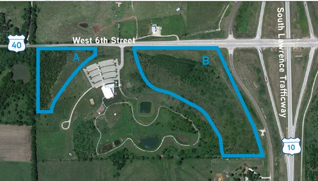
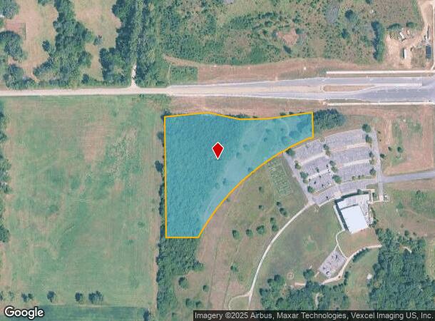
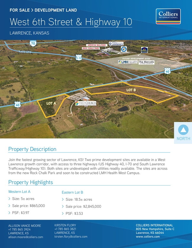
Highway 40
Lawrence, KS
First United Methodist Church 2Nd Plat
023-069-31-0-00-00-001.02-0
FIRST UNITED METHODIST CHURCH 2ND PLAT LOT 1; LESS ROW DEED 1218/2964 (SPLIT 2023)
Residentialacreage
Douglas
X
Kansas
20045C0152E
1
2025
4.50 AC
2025
Lawrence
000701
Kansas City
DEMOGRAPHICS near Highway 40
1 Mile
3 Mile
5 Mile
2024 Total Population
948
20,850
59,194
2029 Population
976
21,303
60,225
Pop Growth 2024-2029
+ 2.95%
+ 2.17%
+ 1.74%
Average Age
40
40
37
2024 Total Households
342
9,266
24,809
HH Growth 2024-2029
+ 3.22%
+ 2.33%
+ 1.93%
Median Household Inc
$128,676
$79,881
$61,658
Avg Household Size
2.70
2.20
2.20
2024 Avg HH Vehicles
2.00
2.00
2.00
Median Home Value
$437,248
$375,065
$282,404
Median Year Built
2009
2004
1993
Nearby Places
Map Layers
Map Styles
 Street
 Aerial
- Restaurants
- Banks
- Shops
- Fitness
- Groceries
PUBLIC TRANSPORTATION
COMMUTER RAIL
DRIVE
WALK
Distance
13 min
6.2 mi
Nearby Properties
Address
Land Use
TOTAL SIZE
Lot Size
Zoning
Address
Land Use
TOTAL SIZE
Lot Size
Zoning
243,311 SF
20.07 AC
AG
Address
Land Use
TOTAL SIZE
Lot Size
Zoning
190,168 SF
55.04 AC
C2
Address
Land Use
TOTAL SIZE
Lot Size
Zoning
138,043 SF
26.20 AC
AG
Address
Land Use
TOTAL SIZE
Lot Size
Zoning
11,992 SF
118.15 AC
RS1
Address
Land Use
TOTAL SIZE
Lot Size
Zoning
1,034 SF
254.80 AC
AG
Address
Land Use
TOTAL SIZE
Lot Size
Zoning
56,172 SF
14.05 AC
AG
Address
Land Use
TOTAL SIZE
Lot Size
Zoning
55,556 SF
24.90 AC
RM1
Address
Land Use
TOTAL SIZE
Lot Size
Zoning
55,275 SF
12.30 AC
AG
Address
Land Use
TOTAL SIZE
Lot Size
Zoning
51,366 SF
15 AC
RS2
Address
Land Use
TOTAL SIZE
Lot Size
Zoning
560,356 SF
62 AC
Address
Land Use
TOTAL SIZE
Lot Size
Zoning
40,349 SF
5.02 AC
C2
Address
Land Use
TOTAL SIZE
Lot Size
Zoning
20,062 SF
23.60 AC
A1
Address
Land Use
TOTAL SIZE
Lot Size
Zoning
24,083 SF
3.60 AC
Address
Land Use
TOTAL SIZE
Lot Size
Zoning
21,147 SF
0.49 AC
Address
Land Use
TOTAL SIZE
Lot Size
Zoning
47,666 SF
Address
Land Use
TOTAL SIZE
Lot Size
Zoning
10,000 SF
18.60 AC
AG
Address
Land Use
TOTAL SIZE
Lot Size
Zoning
67,324 SF
5.83 AC
Address
Land Use
TOTAL SIZE
Lot Size
Zoning
11,712 SF
1.34 AC
M1
Address
Land Use
TOTAL SIZE
Lot Size
Zoning
6,516 SF
16.25 AC
Address
Land Use
TOTAL SIZE
Lot Size
Zoning
15,543 SF
9.30 AC
AG
Address
Land Use
TOTAL SIZE
Lot Size
Zoning
33,820 SF
22.06 AC
Address
Land Use
TOTAL SIZE
Lot Size
Zoning
643.10 AC
AG
Address
Land Use
TOTAL SIZE
Lot Size
Zoning
650 SF
9.70 AC
AG
Address
Land Use
TOTAL SIZE
Lot Size
Zoning
4,384 SF
57 AC
Address
Land Use
TOTAL SIZE
Lot Size
Zoning
13,512 SF
5 AC
AG
Address
Land Use
TOTAL SIZE
Lot Size
Zoning
26,688 SF
14.34 AC
AG
Address
Land Use
TOTAL SIZE
Lot Size
Zoning
16,792 SF
29.57 AC
AG
Address
Land Use
TOTAL SIZE
Lot Size
Zoning
21,082 SF
9.42 AC
RM1
Address
Land Use
TOTAL SIZE
Lot Size
Zoning
493.10 AC
AG
Address
Land Use
TOTAL SIZE
Lot Size
Zoning
17,025 SF
20.80 AC
The World's #1 Commercial Real Estate Marketplace
Connect with us
© 2026 CoStar Group
The information above has been obtained from sources believed reliable. While we do not doubt its accuracy we have not verified it and make no guarantee, warranty or representation about it. It is your responsibility to independently confirm its accuracy and completeness. Any projections, opinions, assumptions, or estimates used are for example only and do not represent the current or future performance of the property. The value of this transaction to you depends on tax and other factors which should be evaluated by your tax, financial, and legal advisors. You and your advisors should conduct a careful, independent investigation of the property to determine to your satisfaction the suitability of the property for your needs.