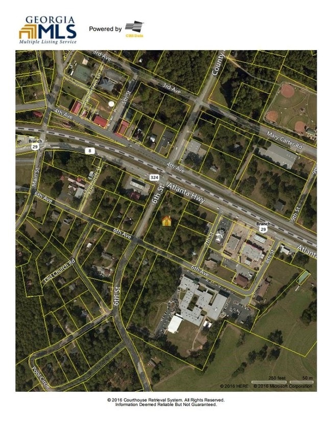
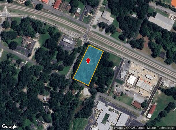
Property Record
6Th St, Auburn, GA 30011
This Property Is For Sale
NEARBY LISTINGS FOR SALE OR LEASE
Property Detail
6Th St
AU11-121
Waterside At Riverwalk
Commercialnec
HWY 8
X
Barrow
13013C0040D
Georgia
2024
2 AC
2024
Barrow County
180106
Atlanta
1,540 SF
Atlanta-Sandy Springs-Roswell, GA
DEMOGRAPHICS near 6Th St
1 Mile
3 Mile
5 Mile
2024 Total Population
2,688
17,290
62,466
2029 Population
3,141
20,028
69,611
Pop Growth 2024-2029
+ 16.85%
+ 15.84%
+ 11.44%
Average Age
37
38
37
2024 Total Households
937
5,841
20,012
HH Growth 2024-2029
+ 17.08%
+ 16.21%
+ 11.90%
Median Household Inc
$65,172
$71,600
$88,346
Avg Household Size
2.90
2.90
3.10
2024 Avg HH Vehicles
2.00
2.00
2.00
Median Home Value
$172,804
$197,651
$271,936
Median Year Built
1989
1993
2000
Nearby Places
- Restaurants
- Banks
- Shops
- Fitness
- Groceries
Nearby Properties
Address
Land Use
TOTAL SIZE
Lot Size
Zoning
Address
Land Use
TOTAL SIZE
Lot Size
Zoning
222,481 SF
23.20 AC
M-1
Address
Land Use
TOTAL SIZE
Lot Size
Zoning
134,673 SF
29.74 AC
RA200
Address
Land Use
TOTAL SIZE
Lot Size
Zoning
Address
Land Use
TOTAL SIZE
Lot Size
Zoning
202,250 SF
36.80 AC
M-1
Address
Land Use
TOTAL SIZE
Lot Size
Zoning
137,200 SF
20 AC
M-2
Address
Land Use
TOTAL SIZE
Lot Size
Zoning
24,188 SF
40.70 AC
M-1
Address
Land Use
TOTAL SIZE
Lot Size
Zoning
26,616 SF
0.70 AC
Address
Land Use
TOTAL SIZE
Lot Size
Zoning
26,616 SF
0.70 AC
Address
Land Use
TOTAL SIZE
Lot Size
Zoning
84,363 SF
20.80 AC
C-2
Address
Land Use
TOTAL SIZE
Lot Size
Zoning
69,285 SF
53.10 AC
M-2
Address
Land Use
TOTAL SIZE
Lot Size
Zoning
363.92 AC
RA200
Address
Land Use
TOTAL SIZE
Lot Size
Zoning
151.81 AC
Address
Land Use
TOTAL SIZE
Lot Size
Zoning
65,500 SF
10.50 AC
DOWNTOWN O
Address
Land Use
TOTAL SIZE
Lot Size
Zoning
71,300 SF
13.80 AC
M-2
Address
Land Use
TOTAL SIZE
Lot Size
Zoning
60,307 SF
33.40 AC
AG
Address
Land Use
TOTAL SIZE
Lot Size
Zoning
387.40 AC
AG
Address
Land Use
TOTAL SIZE
Lot Size
Zoning
24,400 SF
20 AC
M-2
Address
Land Use
TOTAL SIZE
Lot Size
Zoning
2,455 SF
14.70 AC
RM8
Address
Land Use
TOTAL SIZE
Lot Size
Zoning
1,736 SF
24.20 AC
RM8
Address
Land Use
TOTAL SIZE
Lot Size
Zoning
6,000 SF
25.40 AC
M-2
Address
Land Use
TOTAL SIZE
Lot Size
Zoning
36,450 SF
7.80 AC
M-2
Address
Land Use
TOTAL SIZE
Lot Size
Zoning
3,960 SF
5 AC
M-2
Address
Land Use
TOTAL SIZE
Lot Size
Zoning
16,705 SF
6.60 AC
M-2
Address
Land Use
TOTAL SIZE
Lot Size
Zoning
100 AC
RA200
Address
Land Use
TOTAL SIZE
Lot Size
Zoning
76.58 AC
RA200
Address
Land Use
TOTAL SIZE
Lot Size
Zoning
70.98 AC
Address
Land Use
TOTAL SIZE
Lot Size
Zoning
7,800 SF
2.20 AC
PSV
Address
Land Use
TOTAL SIZE
Lot Size
Zoning
117.66 AC
RA200
Address
Land Use
TOTAL SIZE
Lot Size
Zoning
82.32 AC
RA200
Address
Land Use
TOTAL SIZE
Lot Size
Zoning
9,459 SF
2.60 AC
AG
The World's #1 Commercial Real Estate Marketplace
Connect with us
© 2025 CoStar Group
The information above has been obtained from sources believed reliable. While we do not doubt its accuracy we have not verified it and make no guarantee, warranty or representation about it. It is your responsibility to independently confirm its accuracy and completeness. Any projections, opinions, assumptions, or estimates used are for example only and do not represent the current or future performance of the property. The value of this transaction to you depends on tax and other factors which should be evaluated by your tax, financial, and legal advisors. You and your advisors should conduct a careful, independent investigation of the property to determine to your satisfaction the suitability of the property for your needs.