Property Record
7 7Th St, Riverbank, CA 95367


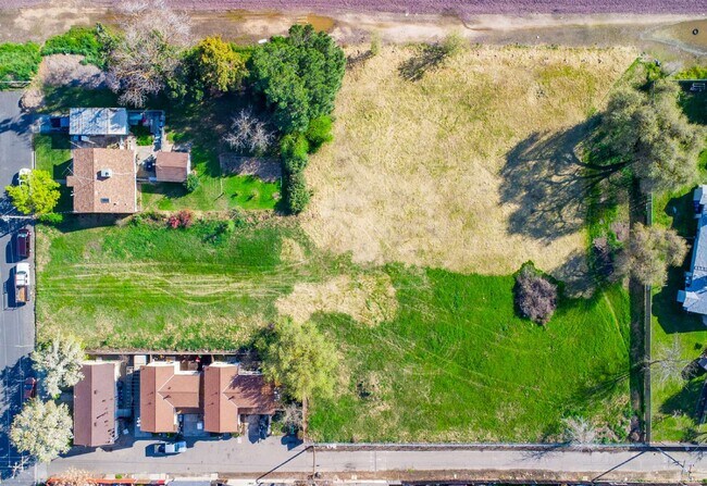

This Property Is For Sale
NEARBY LISTINGS FOR SALE OR LEASE
Property Detail
7 7Th St
Modesto, CA
Riverbank
132-15-23
Stanislaus
Residentialacreage
California
X
2&3
06077C0835F
1.17 AC
2025
Modesto
2025
Stockton/Modesto
000303
DEMOGRAPHICS near 7 7Th St
1 Mile
3 Mile
5 Mile
2024 Total Population
11,677
29,536
112,235
2029 Population
11,649
29,543
112,507
Pop Growth 2024-2029
(0.24%)
+ 0.02%
+ 0.24%
Average Age
36
36
38
2024 Total Households
3,416
8,873
37,747
HH Growth 2024-2029
(0.26%)
+ 0.02%
+ 0.22%
Median Household Inc
$67,674
$86,738
$88,704
Avg Household Size
3.40
3.30
2.90
2024 Avg HH Vehicles
2.00
2.00
2.00
Median Home Value
$357,222
$427,588
$437,302
Median Year Built
1983
1993
1985
Nearby Places
Map Layers
Map Styles
 Street
 Aerial
- Restaurants
- Banks
- Shops
- Fitness
- Groceries
PUBLIC TRANSPORTATION
COMMUTER RAIL
Modesto (San Joaquins - Amtrak)
DRIVE
WALK
Distance
Modesto (San Joaquins - Amtrak)
11 min
5.7 mi
AIRPORT
Stockton Metro
DRIVE
WALK
Distance
Stockton Metro
41 min
27.8 mi
Freight Ports
Port of Stockton
DRIVE
WALK
Distance
Port of Stockton
50 min
36.3 mi
Nearby Properties
Address
Land Use
TOTAL SIZE
Lot Size
Zoning
Address
Land Use
TOTAL SIZE
Lot Size
Zoning
15.68 AC
RIVPD
Address
Land Use
TOTAL SIZE
Lot Size
Zoning
186,665 SF
10.22 AC
Address
Land Use
TOTAL SIZE
Lot Size
Zoning
123,575 SF
10 AC
PC
Address
Land Use
TOTAL SIZE
Lot Size
Zoning
72,338 SF
5.98 AC
RIVC1
Address
Land Use
TOTAL SIZE
Lot Size
Zoning
140,669 SF
10.96 AC
PC
Address
Land Use
TOTAL SIZE
Lot Size
Zoning
77,578 SF
7.93 AC
Address
Land Use
TOTAL SIZE
Lot Size
Zoning
83,987 SF
4.59 AC
RIVR3
Address
Land Use
TOTAL SIZE
Lot Size
Zoning
88,274 SF
6.32 AC
PC
Address
Land Use
TOTAL SIZE
Lot Size
Zoning
28,560 SF
9.62 AC
Address
Land Use
TOTAL SIZE
Lot Size
Zoning
85,218 SF
3.51 AC
Address
Land Use
TOTAL SIZE
Lot Size
Zoning
57,760 SF
4.89 AC
PC
Address
Land Use
TOTAL SIZE
Lot Size
Zoning
465,061 SF
26.66 AC
CERM1
Address
Land Use
TOTAL SIZE
Lot Size
Zoning
369.73 AC
Address
Land Use
TOTAL SIZE
Lot Size
Zoning
201,657 SF
8.53 AC
Address
Land Use
TOTAL SIZE
Lot Size
Zoning
42,000 SF
2.84 AC
Address
Land Use
TOTAL SIZE
Lot Size
Zoning
71,339 SF
4.26 AC
R3
Address
Land Use
TOTAL SIZE
Lot Size
Zoning
148,750 SF
11.88 AC
Address
Land Use
TOTAL SIZE
Lot Size
Zoning
124,025 SF
7.51 AC
Address
Land Use
TOTAL SIZE
Lot Size
Zoning
12,040 SF
1.35 AC
PC
Address
Land Use
TOTAL SIZE
Lot Size
Zoning
153,738 SF
9.58 AC
Address
Land Use
TOTAL SIZE
Lot Size
Zoning
2,584 SF
306.61 AC
A240
Address
Land Use
TOTAL SIZE
Lot Size
Zoning
804 SF
96.04 AC
A210UT
Address
Land Use
TOTAL SIZE
Lot Size
Zoning
17,000 SF
1.18 AC
C2
Address
Land Use
TOTAL SIZE
Lot Size
Zoning
10,925 SF
1.30 AC
PC
Address
Land Use
TOTAL SIZE
Lot Size
Zoning
20,034 SF
1.59 AC
Address
Land Use
TOTAL SIZE
Lot Size
Zoning
1.55 AC
RIVPD
Address
Land Use
TOTAL SIZE
Lot Size
Zoning
7,920 SF
2 AC
RIVC2
Address
Land Use
TOTAL SIZE
Lot Size
Zoning
33,336 SF
1.02 AC
Address
Land Use
TOTAL SIZE
Lot Size
Zoning
16,996 SF
1.65 AC
Address
Land Use
TOTAL SIZE
Lot Size
Zoning
49,625 SF
2.21 AC
The World's #1 Commercial Real Estate Marketplace
Connect with us
© 2026 CoStar Group
The information above has been obtained from sources believed reliable. While we do not doubt its accuracy we have not verified it and make no guarantee, warranty or representation about it. It is your responsibility to independently confirm its accuracy and completeness. Any projections, opinions, assumptions, or estimates used are for example only and do not represent the current or future performance of the property. The value of this transaction to you depends on tax and other factors which should be evaluated by your tax, financial, and legal advisors. You and your advisors should conduct a careful, independent investigation of the property to determine to your satisfaction the suitability of the property for your needs.