Property Record
7 Brookside Cir, Acton, MA 01720
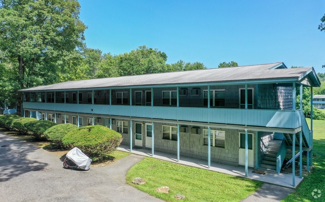
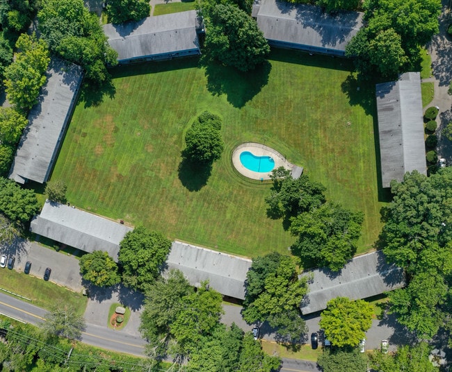
Property Detail
7 Brookside Cir
ACTO-000003H-000241-000001
MIDDLESEX
Nonbuildableland
Massachusetts
R2
1.32 AC
AE The base floodplain where base flood elevations are provided. AE Zones are now used on new format FIRMs instead of A1-A30 Zones.
Acton
2025
Boston
2025
Boston-Cambridge-Newton, MA-NH
363104
NEARBY LISTINGS FOR SALE OR LEASE
-
-
View all Acton listings for sale on LoopNet.com
DEMOGRAPHICS near 7 Brookside Cir
1 mile
3 mile
5 mile
2025 Total Population
4,357
41,273
73,726
2030 Population
4,550
43,038
76,989
Pop Growth 2025-2030
+ 4.43%
+ 4.28%
+ 4.43%
Average Age
42
43
43
2025 Total Households
1,598
15,918
27,689
HH Growth 2025-2030
+ 4.57%
+ 4.44%
+ 4.58%
Median Household Inc
$144,946
$161,011
$175,442
Avg Household Size
2.70
2.50
2.60
2025 Avg HH Vehicles
2.00
2.00
2.00
Median Home Value
$715,909
$773,455
$821,525
Median Year Built
1972
1970
1974
Nearby Places
Map Layers
Map Styles
 Street
 Aerial
Transit
 Traffic
 Biking
Places
Listings with unknown addresses are not visible on the map
- Restaurants
- Banks
- Shops
- Fitness
- Groceries
PUBLIC TRANSPORTATION
COMMUTER RAIL
South Acton (Fitchburg/South Acton Line - Massachusetts Bay Transportation Authority Commuter Rail (Purple Line))
Drive
Walk
Distance
South Acton (Fitchburg/South Acton Line - Massachusetts Bay Transportation Authority Commuter Rail (Purple Line))
6 min
1.8 mi
West Concord (Fitchburg/South Acton Line - Massachusetts Bay Transportation Authority Commuter Rail (Purple Line))
Drive
Walk
Distance
West Concord (Fitchburg/South Acton Line - Massachusetts Bay Transportation Authority Commuter Rail (Purple Line))
6 min
2.6 mi
AIRPORT
General Edward Lawrence Logan International
Drive
Walk
Distance
General Edward Lawrence Logan International
44 min
26.1 mi
Worcester Regional
Drive
Walk
Distance
Worcester Regional
53 min
31.8 mi
Freight Ports
Port of Boston
Drive
Walk
Distance
Port of Boston
44 min
26.1 mi
Nearby Properties
Address
Land Use
TOTAL SIZE
Lot Size
Zoning
Address
Land Use
TOTAL SIZE
Lot Size
Zoning
30.39 AC
I
Address
Land Use
TOTAL SIZE
Lot Size
Zoning
197,727 SF
31.55 AC
R2
Address
Land Use
TOTAL SIZE
Lot Size
Zoning
417,293 SF
64.97 AC
I
Address
Land Use
TOTAL SIZE
Lot Size
Zoning
160 SF
R1
Address
Land Use
TOTAL SIZE
Lot Size
Zoning
22,927 SF
51 AC
IPA
Address
Land Use
TOTAL SIZE
Lot Size
Zoning
263,589 SF
8.76 AC
R2
Address
Land Use
TOTAL SIZE
Lot Size
Zoning
326,464 SF
19.52 AC
I
Address
Land Use
TOTAL SIZE
Lot Size
Zoning
18.78 AC
MP
Address
Land Use
TOTAL SIZE
Lot Size
Zoning
116,968 SF
3.44 AC
WCI
Address
Land Use
TOTAL SIZE
Lot Size
Zoning
25.15 AC
R2
Address
Land Use
TOTAL SIZE
Lot Size
Zoning
77,323 SF
18 AC
C
Address
Land Use
TOTAL SIZE
Lot Size
Zoning
51,504 SF
18.87 AC
C
Address
Land Use
TOTAL SIZE
Lot Size
Zoning
31.29 AC
AA
Address
Land Use
TOTAL SIZE
Lot Size
Zoning
7.88 AC
B
Address
Land Use
TOTAL SIZE
Lot Size
Zoning
155,339 SF
24 AC
R1
Address
Land Use
TOTAL SIZE
Lot Size
Zoning
35.99 AC
HI
Address
Land Use
TOTAL SIZE
Lot Size
Zoning
20,498 SF
25.75 AC
GI
Address
Land Use
TOTAL SIZE
Lot Size
Zoning
9.56 AC
PM
Address
Land Use
TOTAL SIZE
Lot Size
Zoning
10.34 AC
LB
Address
Land Use
TOTAL SIZE
Lot Size
Zoning
54,892 SF
7.99 AC
AA
Address
Land Use
TOTAL SIZE
Lot Size
Zoning
50,355 SF
6.38 AC
IPA
Address
Land Use
TOTAL SIZE
Lot Size
Zoning
105,036 SF
6.84 AC
KC
Address
Land Use
TOTAL SIZE
Lot Size
Zoning
39,250 SF
0.39 AC
R2
Address
Land Use
TOTAL SIZE
Lot Size
Zoning
76,623 SF
16.59 AC
R2
Address
Land Use
TOTAL SIZE
Lot Size
Zoning
9.61 AC
I
Address
Land Use
TOTAL SIZE
Lot Size
Zoning
63.75 AC
A
Address
Land Use
TOTAL SIZE
Lot Size
Zoning
40 AC
R2
Address
Land Use
TOTAL SIZE
Lot Size
Zoning
75,182 SF
6.74 AC
IPA
Address
Land Use
TOTAL SIZE
Lot Size
Zoning
78,564 SF
3.43 AC
LB
Address
Land Use
TOTAL SIZE
Lot Size
Zoning
33.05 AC
I
The World's #1 Commercial Real Estate Marketplace
Connect with us
© 2026 CoStar Group
The information above has been obtained from sources believed reliable. While we do not doubt its accuracy we have not verified it and make no guarantee, warranty or representation about it. It is your responsibility to independently confirm its accuracy and completeness. Any projections, opinions, assumptions, or estimates used are for example only and do not represent the current or future performance of the property. The value of this transaction to you depends on tax and other factors which should be evaluated by your tax, financial, and legal advisors. You and your advisors should conduct a careful, independent investigation of the property to determine to your satisfaction the suitability of the property for your needs.